
In the heat of the moment
How satellite data are helping authorities and other data users to better understand the impacts of heatwaves and drought and identify warning signs

As Europe reels from its hottest summer on record, satellite data are helping experts to understand the impacts of extreme heat and drought and to identify precursors of drought in certain regions
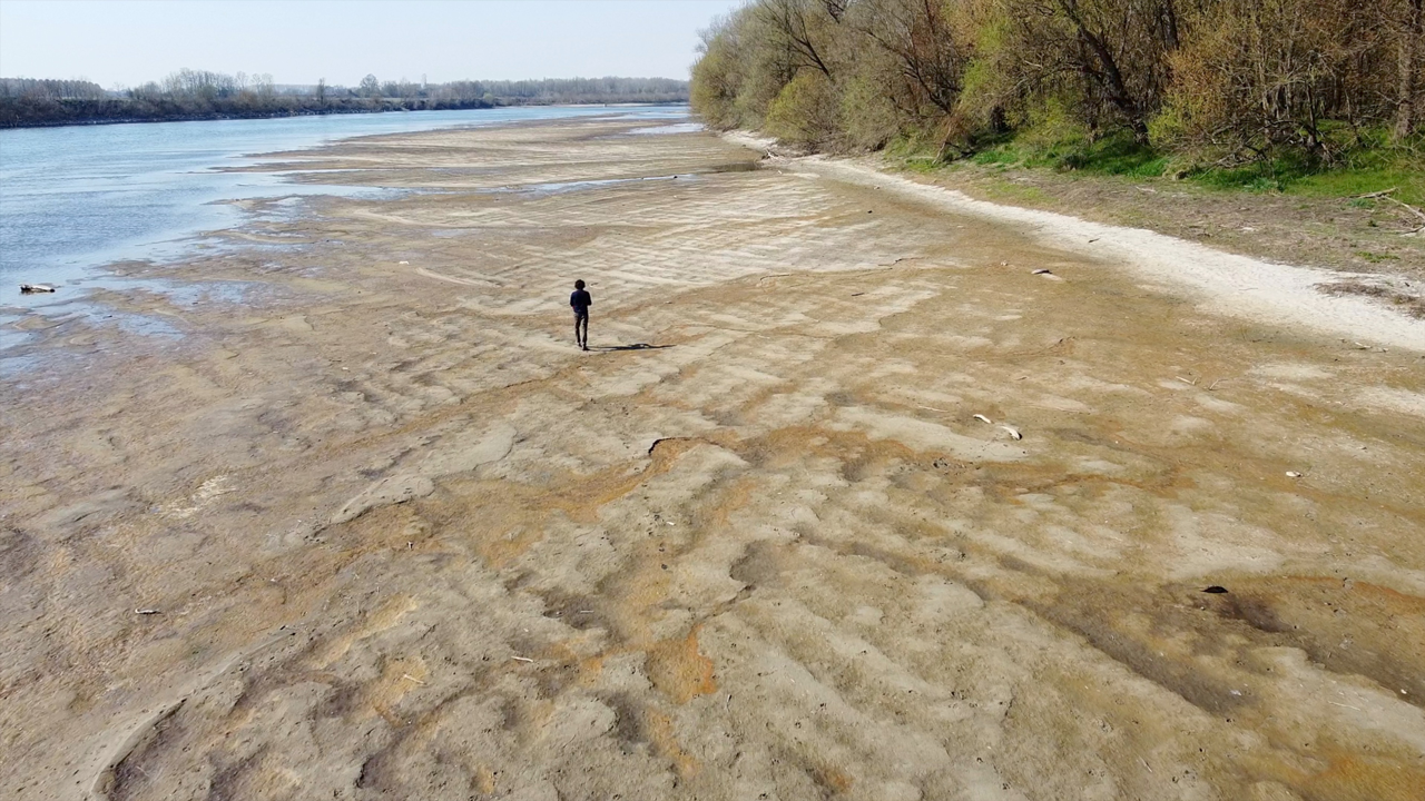
In July 2022, Italy’s government declared a state of emergency across five northern regions as temperatures surged and flow rates of the Po and many of its 141 tributaries plummeted.
But there were signs that a major drought was on the horizon many months earlier.
Record low precipitation leads to serious drought conditions
“Already in February 2022, the Italian Civil Protection Authority put out a warning of a four-month deficit in precipitation,” says Dr Luca Brocca, Director of Research at the Italian National Research Council, in Perugia.
“The Po’s river basin is part of a complex catchment system spanning the southern slopes of the Italian Alps and northern slopes of the Ligurian-Emilian Apennines, and fed by multi-layered networks of rainfall, snowfall and glacier melt.
“In winter 2021-22, northern Italy saw some of the driest conditions in nearly a decade. In the Italian Alps, there was some of the lowest snowfall in the past quarter century. Temperatures were way above average: some of the water retained in glaciers melted away early, in part due to the low snow cover.
“On top of this, the Po Valley was still suffering from the effects of drought in previous years. By the end of February 2022, the Po’s water levels were like those expected in August.
“When the heatwaves hit in summer, it was a recipe for disaster.”
Brocca, who contributes to EUMETSAT’s Support to Operational Hydrology and Water Management Satellite Application Facility (H SAF), fears the Po Valley – like many other regions in Europe – is amid a multi-year drought.
It is a situation that is raising pressing questions for the highly productive region on a range of topics, including water management and other climate change adaptation strategies.
“To recover, the Po Valley needs a substantial amount of precipitation spread over several years,” Brocca says. “In 2022, even when the rains returned, underlying problems remained.
“By early 2023, most of south-western Europe is again experiencing drought, and the impact on water resources is expected to be even greater than in 2022 due to a second consecutive year of severe water shortages.
“It’s like if you live with your bank account close to empty: if you don’t get your salary at the right time, you are left in a tough situation.”
Brocca says that meteorological satellite observations are increasingly important as extreme conditions become more frequent because of human-driven climate change.
“It’s a major challenge to really understand all the factors in play,” Brocca says. “Satellite data enable us to see things not possible from the ground – from the effects of weather and climate to the human impacts on the landscape and water cycle.
“For example, precipitation, soil moisture, and solar radiation data will be increasingly important for predicting and managing drought conditions, as will the development of more innovative products that make use of this data and enable authorities to quickly and effectively make sense of what’s happening.”
A brutal wildfire season
The Po was not the only major river affected by Europe’s drought in 2022, as low levels on major waterways such as the Danube, Rhine, and Rhône threatened ecological crises and restricted navigation.
In January 2023, the European Centre for Medium-Range Weather Forecasts (ECMWF) reported that 2022 was the second hottest year ever recorded in Europe – and the hottest summer – based on records stretching back more than six decades.
Blistering heatwaves, clear skies, and dry soils hit large parts of northern, western, and southern Europe.
Data provided by the European Union’s Copernicus Climate Change Service showed that many temperature records were shattered, including monthly temperature records in 12 European countries – many multiple times.
The Portuguese Institute for Sea and Atmosphere (IPMA), reported that five heatwaves struck between May and August, and at the end of summer all the country’s mainland was deemed to be in severe (60%) and extreme (40%) drought. In Portugal, summer 2022 was the fourth warmest in 92 years.
The hot, dry conditions heightened the risk of wildfires. One of the largest broke out in the forests of the Serra da Estrela National Park, located in Portugal’s central mountainous massif.
Fires scarred more than a quarter of the park’s land area in 2022, Portugal’s oldest and largest protected area, which is home to habitats such as forests, mountains, and high plateaus, traditional farmlands, and almost a third of all the plant species found in the country.

Several European countries suffered severe wildfire seasons in 2022.
“Severe drought and high temperatures fuelled a two-week-long wildfire that charred more than 20,000 hectares of the Serra da Estrela National Park, leaving a clear burn scar visible from space,” says Carla Barroso, a Weather Applications & User Training Expert at EUMETSAT, who previously worked as a remote sensing expert at the IPMA in Lisbon.
“The impact has been catastrophic for nature, hugely damaging for local farmers, and the region has been left in really bad shape.”
The Copernicus Atmosphere Monitoring Service reported that in summer 2022 total wildfire emissions in the European Union and the United Kingdom were estimated at 6.4 megatons and thus at the highest level since 2007.

Credit: Courtesy of Copernicus Atmosphere Monitoring Service/ECMWF
Another study by the European Forest Fire Information System reported the highest burnt area recorded since measurements began, with cumulative burned area in the European Union in 2022 estimated to have exceeded 785,000 hectares, more than double the average for 2006-21.
This included major wildfire outbreaks in countries such as Germany, Slovenia, Spain, and France, where the Gironde region saw two major phases of fire activity in July and August, leading to widespread destruction and the temporary evacuation of more than 40,000 people.
“During the summer, satellite data showed that many countries in Europe experienced significantly elevated values of fire radiative power, which is a measure of the intensity of ongoing fires,” says Barroso.
“The past decade has seen the likelihood of major fire and drought events increasing across Europe and other parts of the world. But even by recent standards, 2022 was a particularly shocking year for the number and intensity of wildfires and related emissions.”
The past eight-year period has been the hottest ever recorded globally. What is shown in the data and what we see in our environment is anything but normal, with new record highs being reached almost every year.
“It is critical that everyone understands how extreme the situation is, otherwise there is a risk that these conditions become normalised in people's minds and in turn societies might underestimate the extent of climate change and fail to take mitigation measures.”
Extensive drought across Europe
A preliminary analysis of surface runoff anomalies – deviations from the average patterns of surface runoff – by the European Commission’s Joint Research Centre suggested that in August 2022 Europe was experiencing its most widespread drought for 500 years.
Particularly alarming were some of the most severe soil moisture deficits ever recorded across the continent. Nearly half of Europe’s land was classified by the European Drought Observatory as at ‘warning’ level, an indication that soil moisture is depleted.
Nearly a fifth of the continent was on ‘alert’ level, where vegetation is showing clear signs of stress – potentially posing a threat to ecosystems and food security. Both low soil moisture values as well as vegetation stress can be seen in satellite-based products, as figures 2 and 3 (below) show.
“Already in the first half of 2022, data showed that rainfall over most parts of Europe was well below average,” says Dr David Fairbairn, a scientist in the Earth System Assimilation Section at ECMWF.
“With low levels of precipitation continuing into the summer and hot temperatures causing increased evapotranspiration, root-zone soil moisture became severely depleted in many parts of Europe.


Figure 2: Anomaly of Monthly Soil Wetness Index (in 28cm - 100cm below the surface), compared the period 2006 - 2020. Product: Root Zone Soil Wetness Index provided by H SAF.
Credit: EUMETSAT H SAF
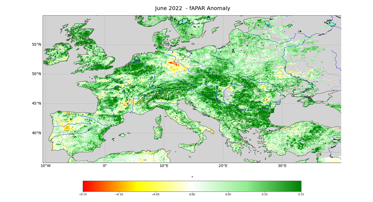


Figure 3: Anomaly of Fraction of Absorbed Photosynthetic Active Radiation (fAPAR) for June, July, and August 2022, compared to the period 2006 - 2020. Product: fAPAR, provided by LSA SAF
Credit: EUMETSAT LSA SAF
“This contributed to forest fires, crop failures, as well as wider stress on the water cycle.”
One of the most effective ways of observing soil moisture over wide areas is by using satellite data provided by instruments making use of active microwaves such as the Advanced Scatterometer on board EUMETSAT’s Metop polar-orbiting satellites.
Experts can use data collected from the soil’s surface layers and assimilate this data into land surface models to infer what’s happening further below.
“Root-zone soil moisture – typically up to around one meter below the surface where the roots of plants take up water – is a very important component of the hydrological cycle,” says Fairbairn, who contributes to EUMETSAT’s H SAF.
“It provides an indication of how water-stressed plants are, and is also an important process to understand in order to make accurate weather predictions.”
Despite rainfall returning to nearly average across much of the United Kingdom by September, many local authorities kept hosepipe bans in place well into the autumn.
“In the root-zone, soil moisture has a long memory – an ability to retain moisture and release it gradually over time – and therefore it can also take a long time to recuperate that water,” Fairbairn says.
“Land surface models, which simulate the exchange of water and energy between the land surface and the atmosphere, indicate that in today’s climate the dire low levels of surface and root-zone soil moisture that we saw in 2022 are still rather exceptional events.
“Nevertheless, long-term data records indicate a trend towards more drought events, shown by a reduction in average root-zone soil moisture in the summer and autumn months since comprehensive records began in 1992.
“The bottom line is that severe droughts are more likely now than 30 years ago, and they are becoming more severe.”
Fairbairn says that satellite data will be critical in guiding responses to these trends.
“Just one example is EUMETSAT’s Metop Second Generation satellites – central components of EUMETSAT Polar System Second Generation (EPS-SG) – which will host instruments that can significantly improve the temporal and spatial resolution of soil moisture observations,” he says.
“Datasets derived from next-generation satellites – such as EPS-SG and Meteosat Third Generation – and related products will support everything from short-term flood prediction to long-term climate adaptation strategies, to improvements in land surface models and forecast systems.”
Preparing for the future
Like other widely used datasets, ECMWF’s fifth generation atmospheric reanalysis of the global climate (ERA5), to which EUMETSAT satellite data make a substantial contribution, indicates that European temperatures have increased at more than twice the global average over the past 30 years.
And, in many parts of the continent, 2023 began in the same vein, with national and local temperature records for December 2022 and January 2023 broken in several places, including southern Spain and eastern and northern parts of Europe.
“Satellite data are crucial in monitoring climatological changes and their effects,” says Dr Christine Träger-Chatterjee, Climate Data Applications Expert at EUMETSAT.
“Vegetation and water resources are being thrown out of their usual rhythms; the moisture needed in spring is more often not there; crop harvests are undermined, adding to existing food crises around the world.
“Moreover, there is little recuperation time – in the longer term it will have terrible implications on harvests, for natural habitats and the communities across Europe that depend on them.”
A big challenge now is to better understand the many puzzles about the main drivers of extreme conditions and how best to respond to them, says Träger-Chatterjee.
“It’s about joining the dots and looking for direct and indirect influences,” she says.
“How are wider phenomena such as polar ice cover and the position and strength of the jet stream impacting events? How is the drought situation building over time? What are the main dynamics underlying weather and climate extremes? How might they change in future?
“Our challenge is to bring different communities together and develop common approaches to try and answer these questions.
“In many respects, although the context is worrying, this is the start of an exciting journey because it requires us to strengthen engagement with users of EUMETSAT data such as national weather centres, emergency responders, and scientific researchers, and explore how existing and new datasets can be used in the most effective way to prepare for the challenges ahead.
“Meteorological satellite data contribute to the bigger picture effectively and efficiently, and on time scales where we can directly compare what is happening now to one, two, three decades ago.
“When heatwaves strike, we do not need to wait until summer is over, but with our data, users can quickly create a map that can provide a near-real-time overview of the situation. And we are currently working on tools to further facilitate that.”
“The quality and continuity of satellite data records over long time series provide significant opportunities, for instance for climate services to design ways to both help monitor situations in real time and to support studies of long-term trends that could help predict what might happen in future.
“Ultimately, we must be proactive and prepared. This means we not only need to improve our abilities to understand, predict, and issue warnings of extreme events, but also improve emergency response and recovery efforts – measures that can benefit immensely from innovative uses of meteorological satellite data.
“Because of global heating, the reality is that situations like extreme heat, drought, and wildfires we saw in 2022 will happen more frequently and potentially more intensely in future. Nature will have less time to recover. The climate is changing rapidly, and we need to do everything we can to address that.”
Author:
Adam Gristwood
Main image: I-RUFA Eurocopter AS 350B3 Firefighter, dropping water in a Forest Fire during Day at Povoa de Lanhoso, Portugal. By Bruno Ismael Alves
