Satellite insights into African dust transport
Using Meteosat and other satellite data to follow African dust plumes across the Mediterranean

Dust originating in Northern Africa reached parts of Europe in early 2024, affecting visibility and air quality. Satellite data from EUMETSAT reveal how this dust travelled more than one thousand kilometres across the Mediterranean Sea.
Spotting a cyclone
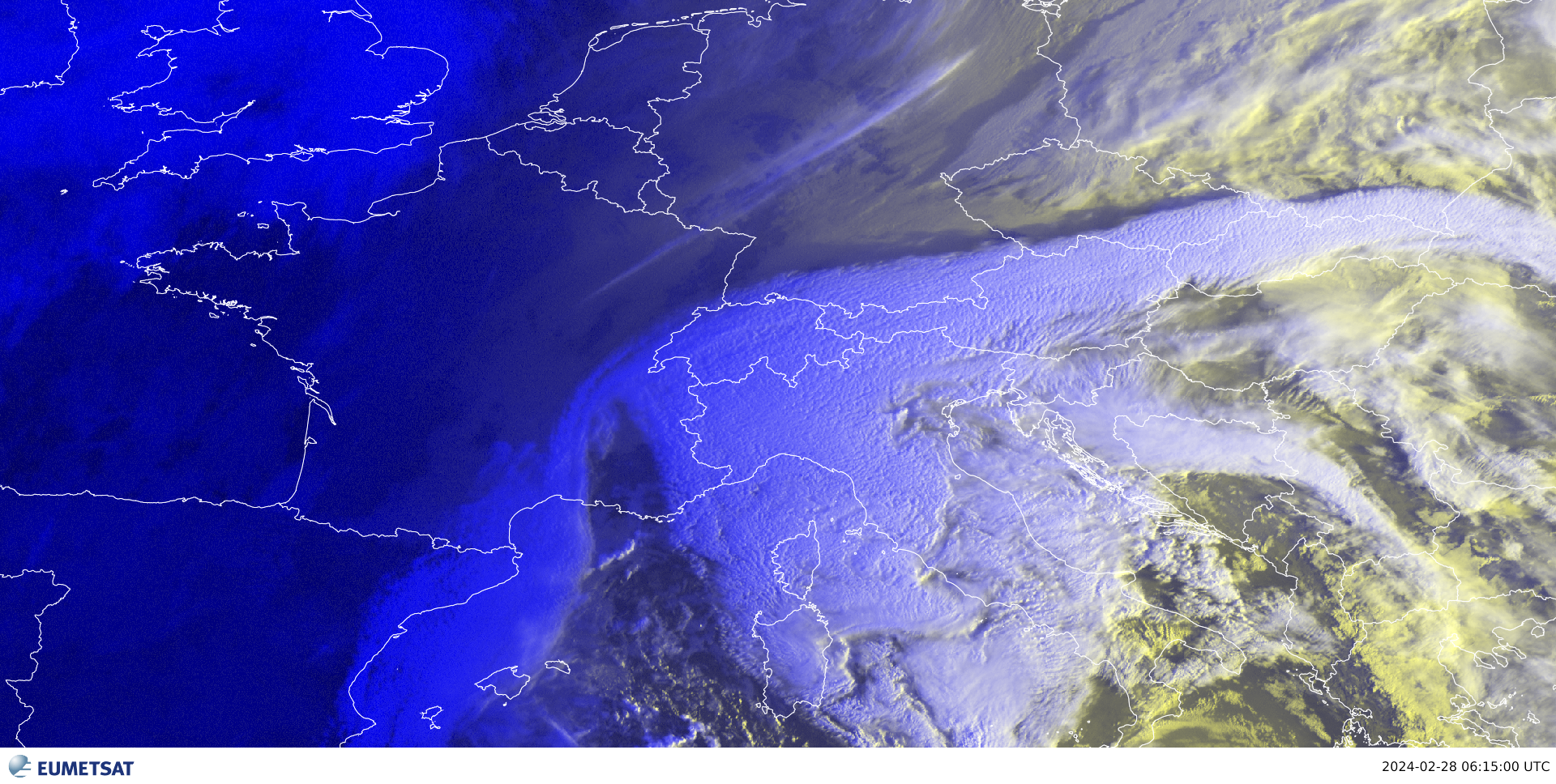
“This animation of the Mediterranean in 2024 was taken by the Spinning Enhanced Visible and Infrared Imager on board the Meteosat-11 satellite,” said Gencic.
Credit: Djordje Gencic, Ivan Smiljanic, Dr Michael Fromm
“For this image, we have compiled individual channels – ranges of wavelengths – of infrared radiation. Each channel or combination of channels – they can be subtracted from one another – has then been assigned the colour red, green, or blue, with each colour representing a different physical property of the atmosphere. This is very useful because it enables us to differentiate cold polar air masses from warm and moist tropical air masses.
“We want to identify where are the main cyclonic circulations and we see one in the middle of the Mediterranean in this animation. The main thing to note from this animation is that it indicates the presence of a cyclone. And beyond this, we can tell that the system is strong. At some points of the animation, inside the cyclone, you can see some parts that are very red. This suggests intensification of the system. We can also see that the cloud tops are cold, which means that they are very high and also indicates that the system is perfectly developed, and, therefore, strong.
“To identify a dust event, you need to see both a cyclone and, of course, the presence of dust, which can be seen in the next image. So, confirming the presence of a cyclone, as we were able to do here, is the first step.”
Grainy clouds mean dust
“In this image, we can see the dust present in the cyclone.
Credit: Djordje Gencic, Ivan Smiljanic, Dr Michael Fromm
“This image is also from the Spinning Enhanced Visible and Infrared Imager on board the Meteosat-11 satellite but instead of being a composite of multiple channels in the infrared range, it is from just one channel in the visible range. The high resolution of this channel allows us to detect this very interesting pattern of dust-infused clouds, which is the grainy or pockmarked texture you can see in the clouds in this image.
“Because cyclones rotate, a dust event like this one entails a continuous process of dust being lifted into the cyclone and then travelling along with it. Systems like this typically move north and east, because this is the prevailing direction of wind in the subtropics and moderate latitudes. As this cloud moves, it gets less dense. This event started as a thick, low-level dust cloud and got thinner and higher as it moved toward Europe, expanding vertically as it travelled.
“Another important thing to note about events like these is that very high in the atmosphere, dust serves as crystallisation nuclei. So, the practical effect of this dust is that there are more nuclei available, and that means that there will be more ice crystals, and when there are a lot of crystals, a cloud forms. When you have a dust event, it is important to be aware that there might be a lot of high-level clouds created from ice crystals.
“In this case, we suspected that we would see this grainy or pockmarked texture indicating that the cloud is full of dust, and that is exactly what we saw.”
Even better detection
“We used imagery from the Spinning Enhanced Visible and Infrared Imager on board Meteosat Second Generation to look at this event because that is what we had available from 2024. Now that the first Meteosat Third Generation satellite, Meteosat-12, is operational, we can also use data from the Flexible Combined Imager to detect dust events like this one.
“This offers a number of advantages. The Flexible Combined Imager has better spatial resolution of one kilometre or even 500 metres in some places, and scans the full Earth disc in only ten minutes using more channels than the Spinning Enhanced Visible and Infrared Imager. In addition, the Flexible Combined Imager is more sensitive, enabling it to detect finer differences and oscillations than its predecessor could.
“These improvements enable us to detect dust better, which is important because dust is also not just some funny phenomenon you see collected on cars in Europe at some point. It is also essential for increasing soil fertility in some regions.
“In addition, in the Middle East and other desert areas, huge dust clouds called haboobs form. The visibility in these storms is very low – around two metres. I do not think there is a better way of identifying the life cycle of these storms than through satellite imagery. At the moment, models are not at the point at which they can be used to identify individual dust clouds. So, products like the ones we used to look at this dust event in the Mediterranean are extremely valuable.”
Are you an expert looking to dive deeper?
Explore the case study here.
Author:
Sarah Puschmann