

02 September 2025
11 December 2018
The Towards fiducial Reference measUrements of Sea-Surface Temperature by European Drifters (TRUSTED) project contributes to the necessary infrastructure for Fiducial Reference Measurements (FRM) needed for the validation of high resolution and high accuracy satellite Sea Surface Temperature (SST) from the Copernicus Sentinel-3 Sea and Land Surface Temperature Radiometer (SLSTR).
This is achieved by providing measurements from a significant number of drifting buoys equipped with additional digital SST probes, to the usual design, in order to achieve a better calibrated capability. These also incorporate the most recent geo-location accuracy and position reporting and time reporting capability. Assessment of these drifting buoy SST measurements for SLSTR SST validation, will be achieved through scientific quality control within the project, and planned Sentinel-3 validation activities.
Objectives
The purpose of the TRUSTED project is to set up a service to "provide well-calibrated drifting buoy SST, towards SI-traceable standards, HRSST-FRM", so that it is then possible to "assess and establish the benefit of improved capability of HRSST-2 drifting buoys for satellite SST validation". Further assessments are ongoing as part of the EUMETSAT activities for Copernicus Sentinel-3 SLSTR SST validation, together with the activities of the Sentinel-3 validation team.
The project incorporates scientific quality control and analysis of the drifting buoy measurements. The projects initial aims were to provide measurements from 150 drifting buoys with an improved capability (HRSST-2 and towards FRM) and to assess their quality in coordination with EUMETSAT and the wider international community.
In the future satellites with even more stringent requirements are expected, including for coastal applications, and those with higher spatial resolutions. Therefore, this project is relevant in the long term for the whole satellite SST constellation.
Coordination of the satellite SST community with the Data Buoy Cooperation Panel (DBCP) continues and is a new way of working and, if successful, may extend to other Essential Climate Variables (ECVs). These new measurements are essential, not only for satellite validation activities in order to ensure the quality of the SLSTR SST products for the users, but also to contribute to algorithm development, and to lead to further necessary improvements.
EUMETSAT needs FRM to deliver the required confidence in the Copernicus data products for users, as outlined in the CEOS Quality Assurance framework for Earth Observation (QA4EO), so it is possible to understand the uncertainties, and how accurate the data products are through full traceability. These FRM measurements protocols are intended to be fully traceable, documented, and long term.
An extension of activities to 2025 focused on the continued service of SST measurements at a rate of 25 buoy deployments per year and development of a new sea-ice surface temperature (IST) FRM drifting buoy, specifically for Sentinel-3 IST validation.
Overview
Earth Observation programmes aim to provide the scientific community with continuous, large scale datasets. Whereas, the in situ observation network provides datasets limited either in time or in space (often high frequency punctual measurements over a short period of time), space-borne Earth Observation systems can provide long term and, often, global datasets, although generally with a lower sampling frequency (usually daily).
Space-borne Earth Observation systems also have the advantage of being able to provide data everywhere, regardless of accessibility issues (geophysical or political), and, for some sensors, regardless of meteorological conditions. In recent years there has been an increase in the number of sensors being flown for oceanographic purposes, also with great improvements in sensor and mission calibration.
Of particular interest to oceanographers and meteorologists is the acquisition of high quality satellite SST data products. Over short time scales, this state variable provides important information on the spatial distribution and intensity of dynamic structures such as eddies, coastal currents, and upwelling region in near real time (down to a few hours after acquisition). Long-term datasets (going back almost four decades) can also provide information on global and regional sea surface temperature trends, which can be used to monitor the evolution of the surface ocean on decadal time scales, and help quantify the intensity of events such as El Niño/La Niña. Both sets of data, long term and short, are critical to the calibration and validation of weather and climate models that provide crucial information on forthcoming climate trends. Furthermore, SST data is a key input to all weather and climate model assimilation schemes, which limits model drift and, hence, improves the quality of forecasts.
The importance of monitoring SST is generally accepted by the oceanographic and meteorological scientific communities. An SST sensor was included in the EU Copernicus-funded Sentinel-3 Earth Observation mission, namely the Sentinel Land Sea Surface Thermal Radiometer (SLSTR) which is flown on the Sentinel-3A and -3B satellites. This sensor has the particularity of being dual view, meaning higher quality SST observations are possible, accounting better for water vapour and aerosol, in addition to the two onboard black body calibration capability. It’s also useful for reference purposes when combined with other satellite SST data, as a continuation from AATSR. This is necessary to ensure the continuity with past SST missions.
However, in order to achieve the desired quality of Earth Observation measurements, the Sentinel-3 SLSTR sensor needs to be calibrated to the highest level. Such a calibration requires the highest possible quality FRM/in situ data for validation. This, in effect, means high quality data and high quality data distribution, both in terms of spatial and time coverage.
As a result, the Copernicus programme is funding a series of dedicated FRM initiatives. These FRM initiatives aim to collect new sets of measurements that are traceable, long term, and calibrated to SI, bringing a high level of quality to oceanography in situ measurements. Among them is the deployment of an array of temperature measuring surface drifters through the Towards fiducial Reference measUrements of Sea-Surface Temperature by European Drifters (TRUSTED) project.
The TRUSTED project team, led by CLS, includes NKE Instrumentation, who design and build the buoys; the SHOM (the Naval Hydrographic and Oceanographic Service), who lead the calibration; Météo-France, who lead the deployments; BSH (the Federal Maritime and Hydrographic Agency of Germany), OceanOps (WMO-IOC Joint Technical Commission for Oceanography and Marine Meteorology in situ Ocean Observing System Monitoring and Coordination Centre), who provide the metadata processing and visualisation tools to monitor the deployments. The Danish Meteorological Institute (DMI, https://www.dmi.dk/) joined the project in 2022 to define the requirements for a new IST FRM drifting buoy and to define the calibration methods and begin to test a new IST prototype sensor and buoy.
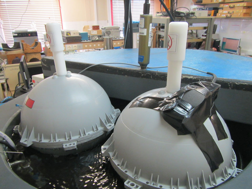
During Phase 1, which ended in June 2018, the SVP-BRST was developed and two prototypes were built and strenuously tested. The drifters carry temperature sensors, one analog (SST) and one digital (TRST, following HRSST-2 specifications), a barometer, a strain gauge, and an iridium modem, allowing them to send back observation data in near real time. Each component of the buoys, as well as the buoys as a whole, were tested either in tanks in the workshop, in a quarry nearby, or out at sea in various weather conditions. This was to ensure that the new buoys met the stringent standards defined by the Data Buoy Cooperation Panel, ensuring that the data collected during the lifetime of the project, and beyond, can be incorporated in the global databases such as the GTS (Global telecommunication System).
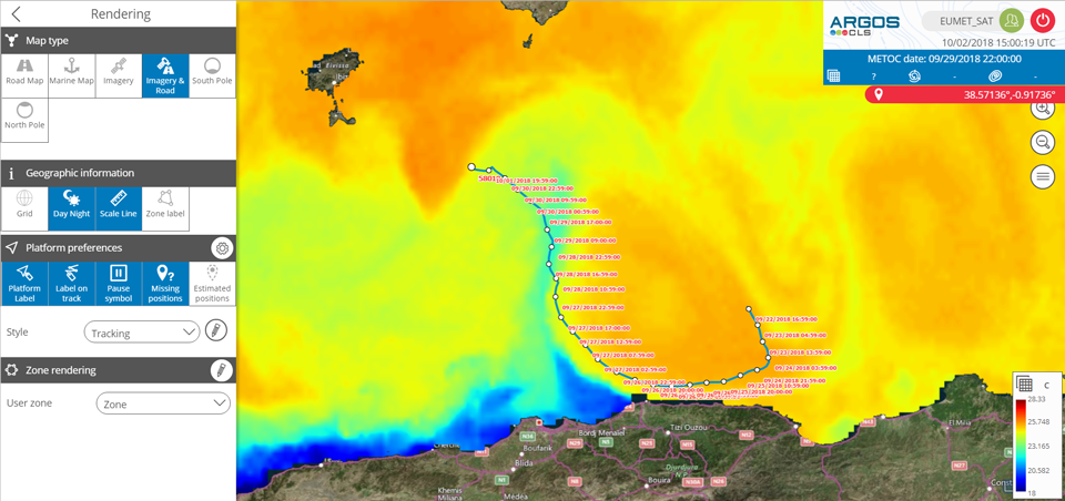
A core part of phase 1 was the metrology testing to ensure that the new instrument, TRST sensor, was tested and calibrated to SI standards. In effect the digital sensor was first calibrated by itself and then within the buoy casing in the SHOM metrology laboratory. The results from the metrology exceeded the project aims, with an error below the 0.01 °C threshold. The buoys were then loaded on the SHOM research vessel Beautemps-Beaupre which was headed for the western Mediterranean. For good measure, the buoys were first put to sea but tethered to the vessel in conjunction with an SI referenced instrument, the SBE 35 installed below a Multi Bottle Sampling Array (MBSA) belonging to the SHOM and immersed just below the surface. Both sets of measurements were then compared to check the accuracy of the sensor. The buoys were finally deployed in the Balearic Sea, south west of Majorca, simultaneously on the 25 April at 22:55 UTC. The location chosen was within an eddy in order to minimise the risk of grounding, always a possibility in enclosed seas such as the Mediterranean. The buoys stayed within the eddy and very close to each other for the first 23 days. After that, they separated and one ran aground on the Algerian coast, just east of the city of Amara (Figure 2).
During the second phase, which started in summer 2018, a further 100 buoys were built and delivered in two batches. They were then deployed globally over an 18 month period, following a deployment plan set up by Météo-France. The aim was to deploy the buoys in areas particularly well suited to satellite data calibration/validation issues, such as areas with little or no cloud cover. Deploying so many buoys and ensuring the traceability of each instrument and dataset requires careful planning and monitoring. To this end, the project relied on the OCEANOPS expertise and tools. This ensures that end users have access to high quality data and meta data to allow them to make the best possible use of the data gathered during the project.
The TRUSTED project will provide Copernicus -> The TRUSTED project provides Copernicus with in situ datasets of the highest quality, now of FRM capability. These enable the validation of the reference Sentinel-3 SLSTR SST products, a key step in ensuring that the Copernicus Earth Observation programme meet its ambitious remit and enabling the Sea Surface Temperature data distributed through the Copernicus marine services to be continuously improved. Furthermore, the buoy data is also available to the global meteorological and oceanographic community as a whole, for analysis, calibration and data assimilation purposes through the GTS, and through the Copernicus marine distribution portals, ensuring that these Copernicus-funded drifters benefit the wider scientific community as a whole.

