28 March 2023
17 January 2022
Observations from space offer a powerful tool for the study of the interaction between clouds and radiation and for the retrieval of cloud properties. In particular, infrared (IR) and microwave (MW) observations offer complementary features with respect to clouds, as IR wavelengths are very sensitive to cloud top but tend to be obscured by thick clouds, while MW wavelengths are relative insensitive to cloud top but carry information on the whole cloud deck. Thus, a combined IR-MW approach to retrieve cloud properties has the potential to exploit the complementary information and overcome the limitations of each.
Despite the presence of both MW and IR passive sensors on operational meteorological satellites, such as the Metop satellites of the European Polar Satellite (EPS) mission, the synergy of MW and IR observations is currently under explored. Key cloud parameters are not part of the operational L2 products available from EPS sensors, such as the Advanced Microwave Sounding (AMSU), the Microwave Humidity Sounder (MHS), and the Infrared Atmospheric Sounding Interferometer (IASI). Among the key parameters are the cloud liquid water content (CLWC) and cloud liquid water path (CLWP), cloud ice water content (CIWC) and cloud ice water path (CIWP), cloud drop effective radius, and the presence of thin cirrus. For these products, no operational heritage from EPS is available. MW and IR observations will continue to be available on future operational missions, such as EPS second generation (EPS-SG), with the Microwave Sounder (MWS) and IASI next generation (IASI-NG).
Objectives
The overall objective of the ComboCloud study was to design, prototype and validate retrieval algorithms for cloud products by using MW and IR measurements in synergy.
Specific objectives were:
- Exploit IASI-NG/MWS synergy for the retrieval of cloud products currently not available from EPS sensors:
- Cloud Liquid Water Content (CLWC)
- Cloud Ice Water Content (CIWC)
- Cloud Liquid Water Path (CLWP)
- Cloud Ice Water Path (CIWP)
- Investigate the benefits of future IASI-NG with respect to current IASI for the retrieval of:
- Cloud effective radius (Re)
- Thin cirrus detection
- Adapt the algorithms to work with current EPS sensors, i.e. AMSU/MHS and IASI.
- Validate the retrievals against existing products from other space-borne sensors.
Overview
The ComboCloud study was conceived as four tasks:
- Literature survey
- Dataset collection
- Algorithm design and development
- Algorithm test and validation.
The study reviewed the current status of IR, MW, and MW-IR algorithms for the retrieval of cloud products, particularly focusing on the profiles of CLWC and CIWC, the column-integrated CLWP and CIWP, the cloud drop effective radius (re), and the detection of thin cirrus.
A simulated dataset of realistic observations was produced processing ECMWF reanalysis data with radiative transfer models (Figure 1), obtaining a large number of simulated radiances and brightness temperatures at MW and IR channels available on current (AMSU/MHS and IASI) and future (MWS and IASI-NG) sensors. The simulated approach was ideal for generating large datasets and evaluating future sensors, serving the needs of the primary objectives of the ComboCloud project, i.e., quantifying the likely improvements brought by IR-MW combination and future observations with respect to what is currently available.

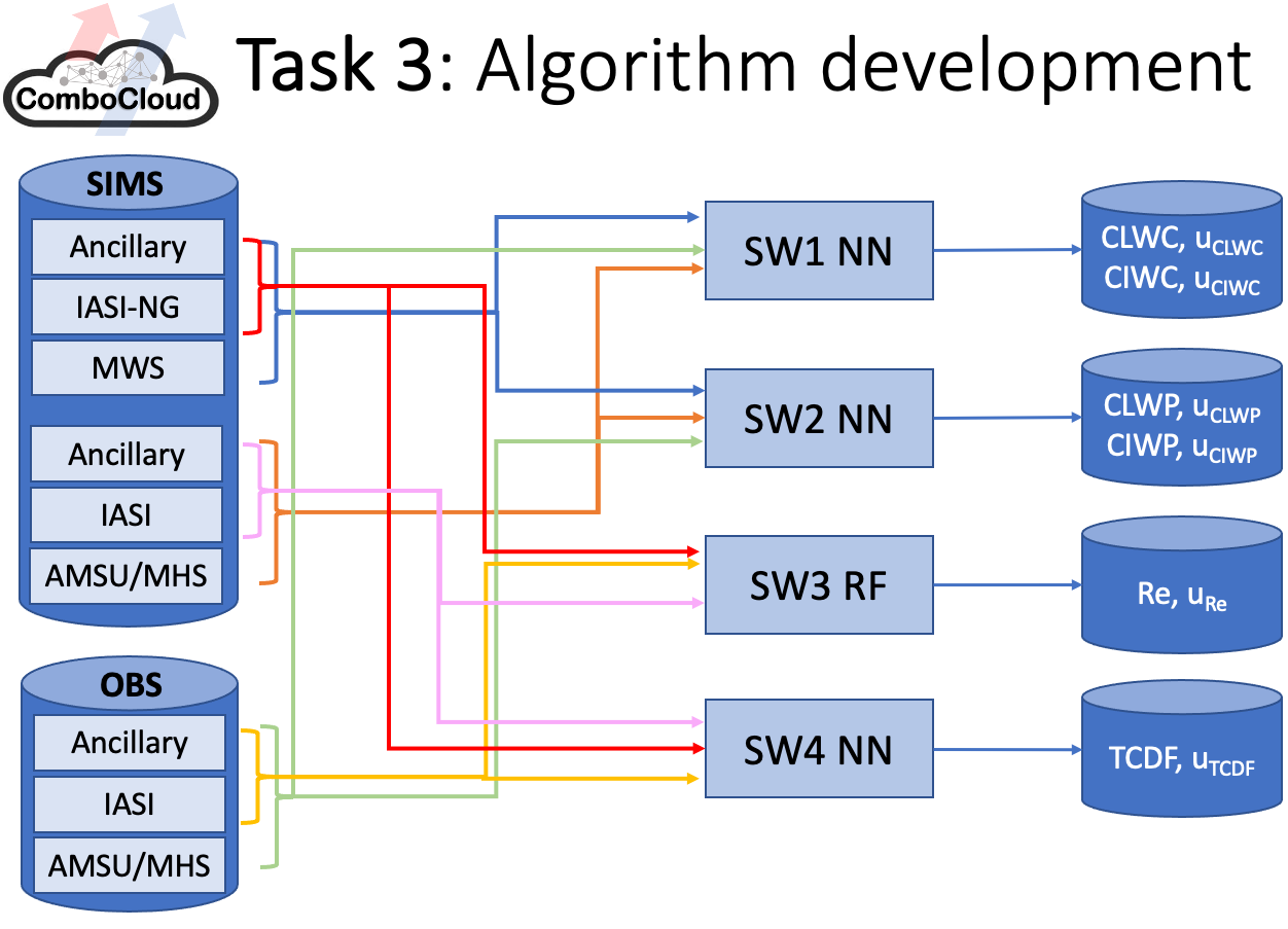
The simulated dataset was exploited to develop and test the retrieval algorithms. Four pieces of software were produced (Figure 2), one for the retrieval of CLWC and CIWC profiles (SW1), one for the retrieval of CLWP and CIWP (SW2), one for the retrieval of the cloud effective radius (SW3), and one for the detection of thin cirrus (SW4). All four SW elements exploit machine learning techniques. In particular, SW1-2-4 are based on artificial Neural Network (NN), while SW3 is based on a Random Forest (RF). The input of SW1 and SW2 are the combined IR-MW observations, while SW3 and SW4 takes in input IR observations only. All the SW codes were developed to work with either current (AMSU/MHS and IASI) or future (MWS and IASI-NG) sensors. The dimensionality of the hyperspectral data (either IASI or IASI-NG) is reduced using Principal Component Analysis (PCA). This step allows a compact representation of the spectra, which is much more efficient for the retrieval algorithms’ development and operational use. Algorithm optimisation was achieved by objective methods like hyperband tuners, random search, and early stopping. The algorithms were trained and optimised on the global dataset. They are applicable at one-pixel resolution and include an estimate of the per-pixel uncertainty.
The validation of the algorithms was performed in two phases (Figure 3):
- Validation with simulated data.
- Validation with real observations.

In the first phase, the developed algorithms were validated against an independent dataset of simulated MW and IR observations and the corresponding ERA5 data. The validation dataset does not include cases used during the algorithm training phase, though it is generated using the same radiative transfer code and settings. The reference data for phase 1 are the original geophysical data from ERA5, i.e. the model data used for the radiative transfer simulations. All the developed algorithms could be validated in this phase, e.g., either exploiting current (AMSU/MHS and IASI) or future (MWS and IASI-NG) sensors. Performance achieved using IR-MW combinations were compared with those obtained with IR- or MW-only, confirming the advantages of sensor synergy. Single-pixel uncertainty was estimated for each algorithm through a binned analysis. The achieved retrieval uncertainty was compared with the requirements set by the user community for each of the considered cloud products (Figure 4).

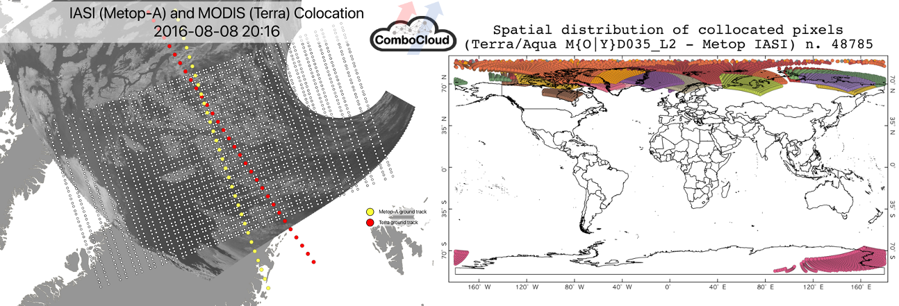
In the second phase, the algorithm settings for current sensors were applied to real observations from IASI/AMSU/MHS instruments flying on Metop satellites and the output products were validated against cloud products from independent satellite instruments. Reference cloud products were collected from satellite active and passive sensors, e.g. Cloudsat 2B-CWC-RO, MODIS MOD35_L2, and VIIRS EDR products. Spatio-temporal collocation was an important aspect. The high variability of clouds in both time and space requires tight criteria for collocation (horizontal, vertical, and temporal). Temporal difference within 10 minutes and distance of the order of IASI FOV footprint radius (~12 km) were adopted. To avoid parallax errors, near nadir observations only (i.e. observing angle within 3° from nadir) were considered. These colocation criteria resulted in match-ups mainly distributed at polar latitudes, because all sensors are in Low-Earth Orbit (LEO) with different local time of the ascending node (Figure 5). To cover a larger range of latitudes, cloud products from a geostationary satellite, SEVIRI OCA, and ECMWF analysis were also adopted as reference.
Validation with real observations was performed for all algorithms, both qualitatively and quantitatively. For example, maps of CLWP and CIWP from SW2 applied to AMSU/MHS and IASI were compared with the same maps from ECMWF analysis, showing consistent spanned range and spatial patterns (Figure 6).

Overall, the ComboCloud project demonstrated quantitatively the value of combining MW and IR observations to retrieve cloud properties with respect to using MW-only or IR-only. The synergistic retrievals demonstrate the combined sensitivity of MW and IR to cloud properties, thus outperforming the performances achievable by either one alone. In addition, the project demonstrated quantitatively the added value of future EPS-SG sensors (IASI-NG and MWS) with respect to the EPS sensors currently available (IASI and AMSU/MHS).