

15 October 2025
23 June 2025
About
The “VIcarious Calibration for MWI and ICI using RadioSoundings” (VICIRS) study designed and developed a vicarious calibration tool for the MicroWave Imager (MWI) and the Ice Cloud Imager (ICI), two conical-scanning radiometers that will fly aboard the Metop-SG satellites B as part of the EUMETSAT EPS-SG program. The study developed a methodology to compare brightness temperature (BTs) measured by ICI and MWI under clear-sky conditions with those simulated from radiosonde profiles using the RTTOV radiative transfer model. Statistical analysis were performed to quantify differences between observed and simulated BTs, accounting for total uncertainty emerging from the various sources for each MWI/ ICI channel. Additionally, the study designed and developed a Multi-source Correlative Methodology (MCM) jointly assessed error characteristics from three collocated BT sources: satellite observations (from MWI or ICI), radiosonde data, and numerical weather prediction model simulations. This framework can be extended to other missions to support the validation of new products.
Objectives
The specific objectives of the study were:
- Development of a methodology analysis for the calibration of MWI/ICI, including:
- Quality checks of radiosounding (RS) data.
- Cloud screening of RS and MWI/ICI observations.
- Emissivity screening of MWI/ICI observations.
- Simulation of BT from RS and Numerical Weather Prediction (NWP) profiles using a Radiative Transfer Model (RTM).
- Bias and uncertainty analysis.
- Update of existing software, specifically the GRUAN processor, incorporating the latest developments in radiative transfer modelling and radiosonde products (GRUAN and RHARM datasets).
- Extension of the tool to support currently operating MW imagers, such as GPM-GMI.
- Validation and verification of the tool using:
- Simulated observations (MWI/ICI L1B test data)
- Real observations from GMI
Overview
The VICIRS study was designed to include four tasks:
- Literature review
- Methodology analysis
- Development of Cal/Val tool
- Cal/Val tool verification and validation.
The first task involved examining vicarious calibration methods in the literature, focusing on microwave (MW) radiometers. A critical review of current approaches for spatial and temporal collocation activities was conducted, alongside an analysis of uncertainty sources and cloud screening methods applied to MW and radio sounding (RS) observations. This review formed the foundation for the methodological analysis and the final development of the VICIRS tool.

Operationally, the VICIRS tool was designed to search for and collect match-ups (MU) (Fig. 1) between MWI/ICI and RS data from two key archives:
- The high-quality, low-density Global Climate Observing System (GCOS) Reference Upper-Air Network (GRUAN) archive,
- The higher-density, non-reference Radiosounding HARMonization (RHARM) dataset, developed in the context of the Copernicus Climate Change Service (C3S).
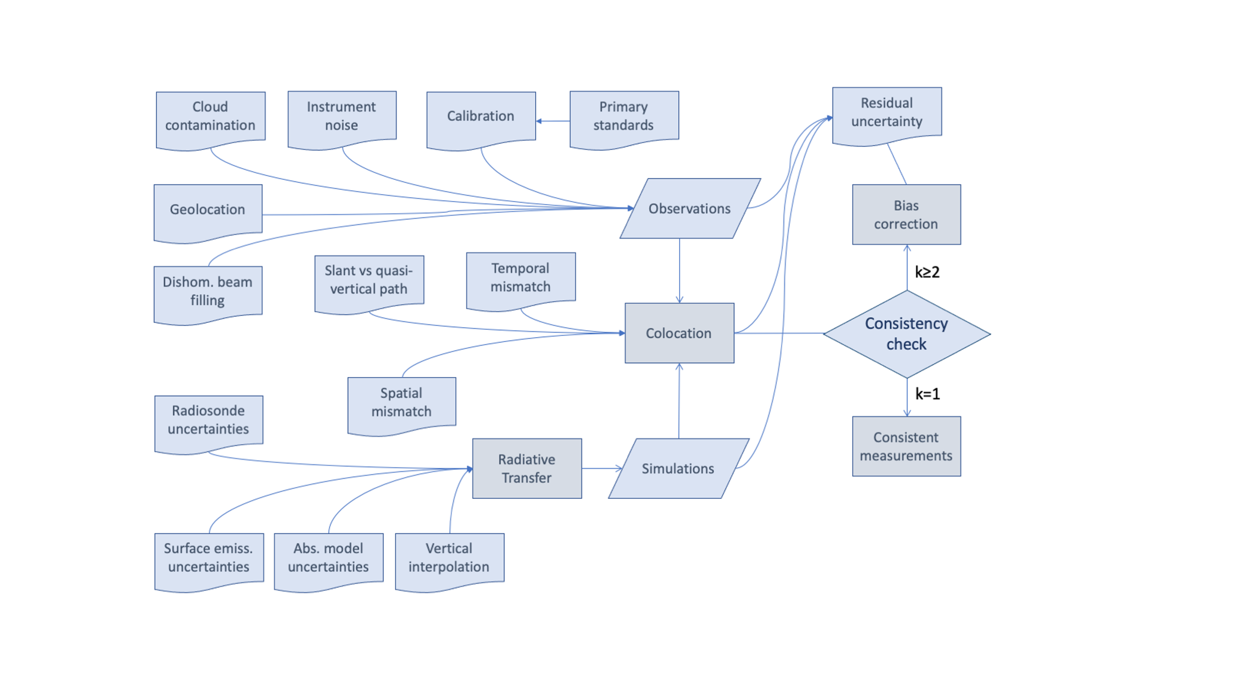
These two archives were selected because they provide quantified uncertainties for temperature (T), relative humidity (RH) and pressure (P) profiles, essential for propagating uncertainties to simulated BTs. The tool also integrates NWP profiles to account for surface parameters and data above the RS burst level. For each MU, various types of Target Areas (TAs) are considered based on the availability of RS drift position data. Statistical analysis of differences between observed and simulated BTs were conducted for each MWI/ICI channel, considering total uncertainties from sources such as instrumental errors, forward model inaccuracies, and spatial/temporal mismatches (Fig. 2).
BT from RS are simulated using the GRUAN processor (https://www.gaia-clim.eu/page/gruan-processor), modified to expand its capabilities to support:
- MWI/ICI channels
- New GRUAN radiosonde types.
- RHARM radiosondes
- Interface compatibility with RTTOV v13.2.
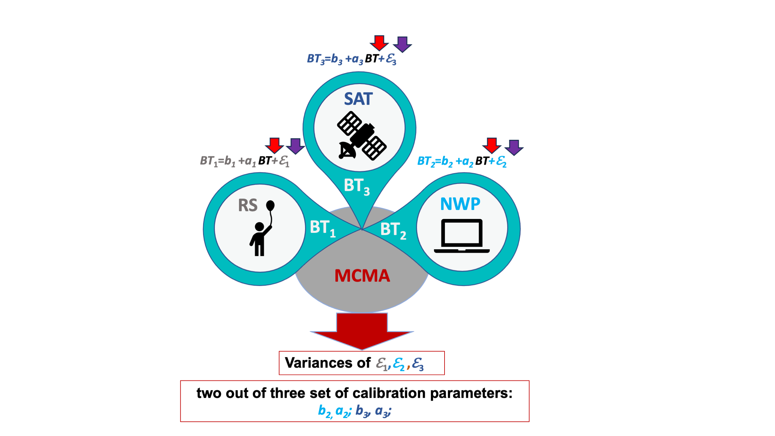
The tool implements Multi-source Correlative Methodology (MCM) to analyse random and systematic uncertainties across three measurement systems: RS, satellite (MWI or ICI), and NWP (Fig. 3). The NWP system used is the ECMWF Integrated Forecasting System (HRES) with ~9 km horizontal grid spacing.
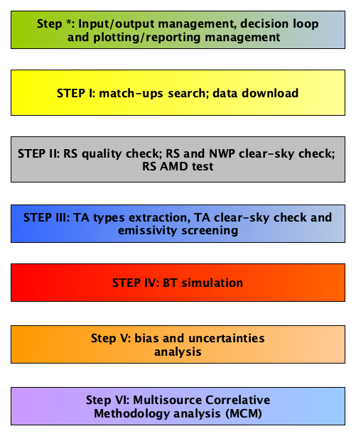
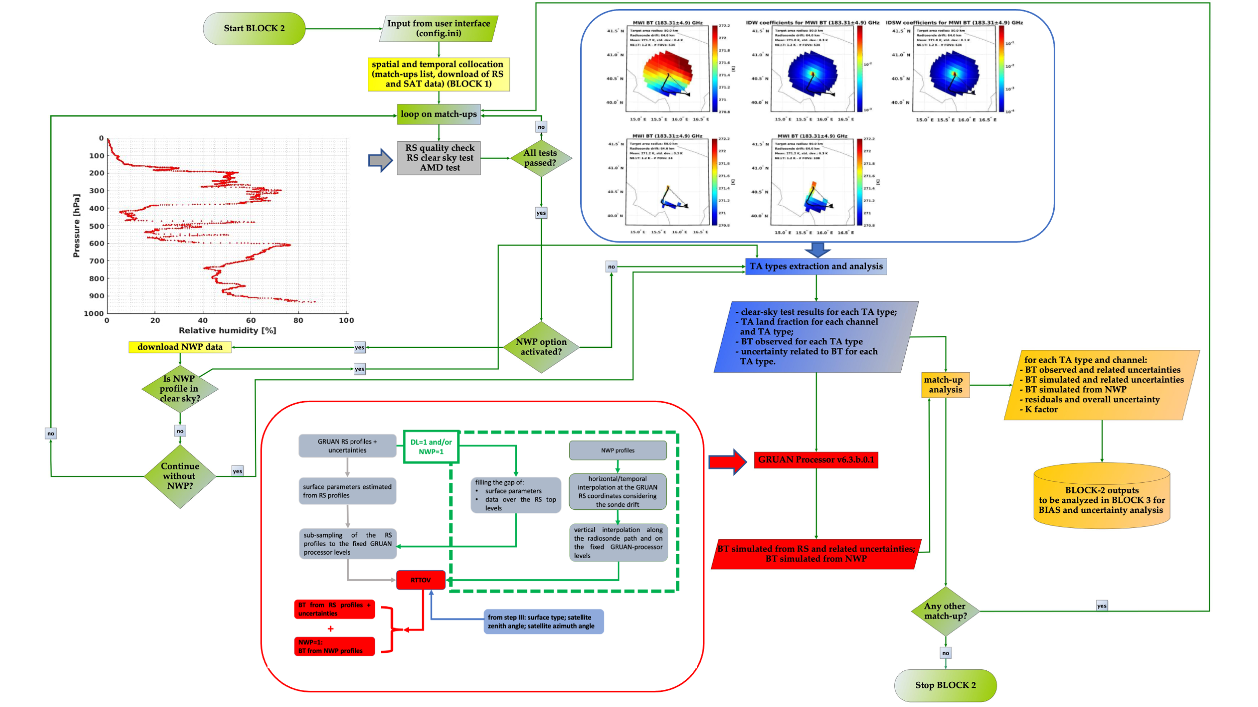
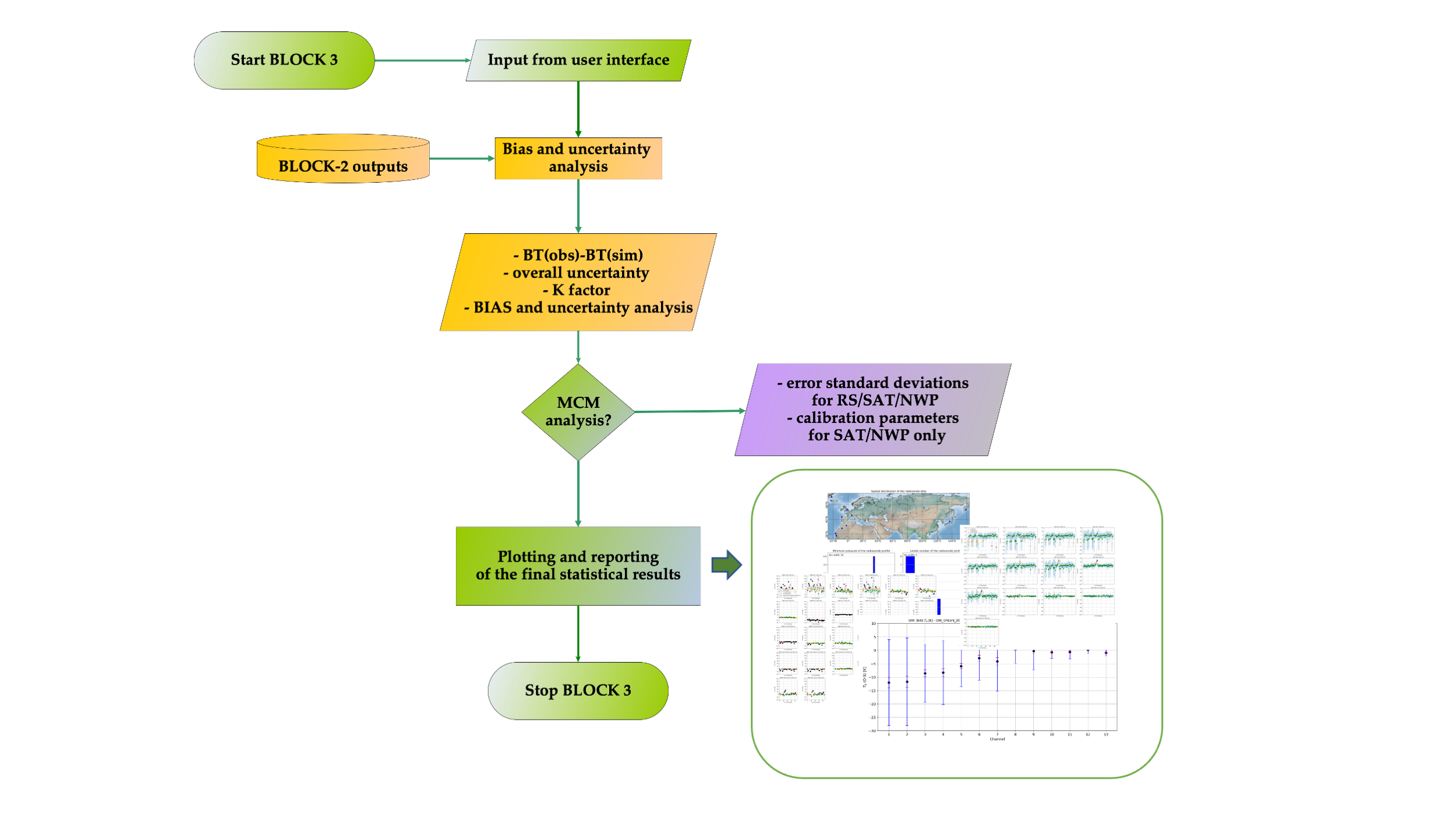
The VICIRS-tool’s workflow is divided into seven steps across three blocks (Fig. 4):
- Block 1 (Front-end): Accepts user-defined search parameters (ini), identifies the match-ups between satellites (SAT) and RS, and downloads the relevant RS/NWP (and SAT for GPM-GMI) data (Fig. 5).
- Block 2 (Core): Processes match-ups to collect data for the statistical analysis ( 5).
- Block 3 (Analysis): Performs the following:
- Statistical analysis of differences between BT observed and simulated, and related uncertainties for each SAT channel and for each match-up;
- BIAS and uncertainty analysis for all the match-ups;
- Multisource Correlative Methodology (MCM) analysis ( 6).
The tool was tested with various datasets, including:
- Simulated MWI/ICI Level 1B observations with spatially/temporally collocated RHARM RS profiles.
- Real GMI observations with spatially/temporally collocated GRUAN RS profiles (consisting of match-ups from six months of 2023).
- Real GMI observations with spatially/temporally collocated RHARM profiles (consisting of match-ups from three months of 2019, covering 20° - 65° latitude North and 15° - 40° longitude East).
The VICIRS tool is now ready for use in MWI and ICI Calibration/Validation activities.