
Aviation weather consultation onboard the RV Polarstern
In the final blog of the series, the students discuss aviation weather reporting for the safety of the helicopter crews coming and going on the mission.

ead on to find out what an Arctic aviation weather report involves, including a case study as an example.
15 March 2021
28 April 2020
Blog seven
Safety first – reliable weather reporting
Authors: Diana Hennings and Isabel Petit
The German research and supply vessel, RV Polarstern, was put into service in 1982 and is, after a long career (including 35 visits to Antarctica and 32 visits to the Arctic), still operated by the Alfred Wegener Institute, Helmholtz Centre for Polar and Marine Research (AWI) in Bremerhaven, Germany.
Since 20 September 2019, the powerful ship has been on the biggest Arctic expedition in history, known as “MOSAiC” (Multidisciplinary drifting Observatory for the Study of Arctic Climate). For this expedition, scientists from 20 nations are on board to take in-situ measurements over a long and continuous period of time in the central Arctic. To make this possible, the Polarstern is frozen within a big ice floe for the next several months to drift along whilst stuck in the ice.
For such a special and risky expedition like MOSAiC (and also for other projects), the ship’s crew, scientists and helicopter pilots need well-supported and reliable weather consultations.

For this reason, there is a meteorological observatory on board, operated by the German Meteorological Service (Deutscher Wetterdienst) and staffed by both a weather technician and a meteorologist.
The weather technician provides daily weather observations and radio soundings, takes care of any maintenance work on the meteorological equipment and prepares data and card material for the meteorologist. The meteorologist, on the other hand, provides detailed weather consultations and the preparation of meteorological products for the different customers on board. For further information on the special tasks of the on-board meteorologist and weather technician, please have a look at previous reports from our fellow students.
The meteorological observatory equipment and database for the on-board weather consultation
For the important work of the on-board weather observatory, special meteorological equipment providing the database for the weather consultation is needed. There is, for example, a satellite receiver for polar-orbiting satellites such as Metop and NOAA satellites -19 and -20. Although the Polarstern is often located in data-poor areas and the number of available satellites is limited/quality varies sharply, the satellite images are one of the most important tools available in order to be able to deliver weather monitoring and forecasting in the central Arctic.
Other important tools are the radio soundings, taken at the same time intervals every day (00:00, 06:00, 12:00, 18:00 UTC) with the goal of getting a vertical profile of the atmosphere in terms of air temperature, pressure, humidity and wind velocity and direction up to the height of around 35km.
Furthermore, there are different measuring sensors like air temperature, relative wind velocity and direction, humidity, pressure, precipitation, global radiation, water temperature, visibility and ceiling installed on the ship. Even though there is versatile equipment and support available from the maritime weather office in Hamburg, the weather monitoring and forecasting on board, especially within the Arctic regions and during the polar night (see previous blog) is not easy.
Hazards for helicopter operations within the Polar Regions
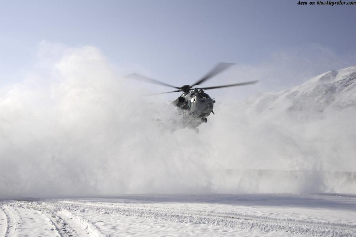
In addition to the meteorologists, the helicopter pilots on board also have to deal with difficult working conditions and challenges, especially during flight operations in the Arctic. First of all, there is the so called “white-out” which can occur when the pilot lands on snow (see Fig. 2 below). The helicopter's rotor blades whirl up snow and consequently, the pilot has difficulty seeing their surroundings and has to land pretty much by sheer instinct, hoping that the ground is stable and flat.

Another problem that can arise is the landing on the Polarstern itself. It all depends on the direction and speed of the wind, which is an issue reserved exclusively for the MOSAiC expedition; if the ship were sailing on the high seas, the crew would try to turn the ship so that the helicopter could fly against the wind upon landing. Unfortunately, this is not possible in the Polarstern's frozen state. So occasionally, the pilots have to land with an unfavourable crosswind or tailwind.
Furthermore, poor visual conditions are also dangerous. Currently, the polar night is occurring in the Arctic, so the pilots have to fly using Night Visual Flight Rules (VFR). The minimum visibility conditions can quickly become a problem in the Arctic, since low clouds and fog occur relatively often there.
Another hazard the pilots are very sensitive to is the freezing precipitation, because it can affect the flight characteristics of the helicopter. However, at the moment, freezing precipitation rarely happens in the upper Arctic. Finally there are some ice-free areas in the Arctic which can cause dangerous situations as well. These areas appear, for example, due to the movement of ice floes. When the air temperature is low enough, sea smoke forms over the ice-free areas, which can condense into fog and could form stratus clouds. The consequences are that convection and turbulence can occur in the vicinity of such an ice-free area. This is particularly dangerous on a polar night because the pilots only notice these areas when they are already flying over them.
Aviation weather report
The meteorologist onboard issues two types of weather reports; the first one is a general report for the captain and the ship’s command, the other one is an aviation weather report for the helicopter pilots. The general aviation weather report is important for the preparation of the flight operation and shall be described here in more detail.
It usually consists of two pages and contains various sub-topics. The report starts with general information like the identification name of the on-board weather station. Then, there is the identifier of the expedition and the sequence number of the aviation weather report. The current position of the ship is also listed, which is given with degrees of longitude and latitude. With regards to the MOSAiC expedition, there is also a hint that the ship is located in a floe. After that, the validity period of the aviation weather forecast follows. The report is usually valid for a couple of hours, which is only a short period of time compared to the usual longer validity periods for Terminal Aerodrome Forecasts (TAFs). The period is coordinated directly with the pilots beforehand and is rarely over five hours.
The ship’s course can also be found in the report. Since the Polarstern is currently trapped in the ice, one cannot predict the course exactly and it simply says that the change in position is around a few hundred meters per hour.
The actual written-out report about the current weather situation and forecast begins after these notes. At first, the general weather situation and the weather situation before the flight operation are described. In particular, the pressure conditions are discussed, as well as the overall wind conditions and whether special air mass movements can be recognised. The aviation weather forecast follows next. Information about the clouds, e.g. the degree of coverage and ceiling, is published and also from where the clouds are coming. Significant weather and changes in visibility are described as well. Last but not least, the forming wind conditions are mentioned and possible inversions may also be added.
Next are the Meteorological Aerodrome Routine Reports (METARs) and the Polarstern Airfield Forecasts (PAFs) which are summarised in the sub-topic aerodrome forecast. METARs report on the current weather at the landing site, so in this case the Polarstern itself. Issued METARs shortly before take off are included in this section, followed by the PAF - the PAF is actually the same as a TAF, it just has a different name onboard the Polarstern.
After the aerodrome forecast, the last two sections of the aviation weather report follow. First, the measured values from the last radio sounding are listed in tabular form. The necessary parameters such as altitude, corresponding pressures, wind, temperatures and spreads are specified. There is also additional information about wind shear with height and temperature gradients, dependent on time and place.
At the end of the aviation weather overview, there are possible hazards and additional parameters to be found in a short-form version. Information about ice, possible turbulence and visibility is particularly important for the helicopter pilot. Currently, information such as water temperature and wave height play a minor part, especially since the ship is mainly surrounded by thick ice.
Case example: Flight operations on 19/11/2019
In order to be able to explain an aviation weather forecast in more detail, we have selected the date of 19 November 2019 as a case example.
The flight took place from 03:45 to 05:15 UTC, converted into on-board time that means from 09:45 to 11:15. The helicopter flew about 20km from the ship during its operation and its course was southbound. For the task itself, the pilot was instructed to fly to an outpost station and to perform a laser scan.
General weather situation at 00:00 UTC (a few hours before the flight operations took place)
On the considered day of 19 November 2019, the geographical position of the Polarstern was 85° N and 120° E (see Fig. 3).
There is a low-pressure area north of Greenland, which influences the Polarstern and its surrounding area because this low pressure area is also moving northwards. Then, there is a high-pressure area over the north of Russia which has an impact on the eastern Arctic. The combination of these two pressure areas results in wind coming from the west/southwest (see arrow in Fig. 3).

Important to notice is that there is some warmer air with temperatures around -4°C to 0°C on the left-hand side in the 850 hPa-pressure surface chart (see Fig. 4). This warmer air shows some bulges or a fanning in the direction of the North Pole (see red point = geographical North Pole in Fig. 4). With wind from the west, this milder humid air is transported in the direction of the Polarstern.

The radio sounding (Fig. 5), recorded by the on-board meteorologist on one of the meteorological main dates at 00:00 UTC, is shown by a Stüve-diagramm. In general, there is a stable air stratification and from 750 hPa to 650 hPa, there is a humid indifferent stratification. Furthermore, the temperature curve shows some inversions.
There is one in the ground level air layer, two between 850 hPa - 730 hPa and a striking subsidence temperature inversion in 410 hPa. In the ground-level air layers, it is dryer with a spread of 7K at the widest point in 960 hPa. Above 920 hPa, there is a spread of circa 2 to 3K, which suggests a strong cloudiness in this radio sounding. Furthermore, there is a ground temperature of ca. -13°C to -14°C and a wind velocity of ca. 10 kt (see the wind arrows on the right-hand side in Fig. 5).
With the height, especially above the friction layer (ca. 1.5km), there is a slight increase in wind speed and a right turning of the wind up to ca. 5km, which confirms the warmer air advection from the west.

The satellite image from 00:00 UTC (Fig. 6) was taken by the polar-orbiting satellite Suomi/NPP's measuring instrument, the Visible Infrared Imaging Radiometer Suite (VIIRS). The shown RGB composite (red: IR 3.7i, blue: IR 10.76i, green: IR 12.01i) was created especially for fog and low stratus detection in the Arctic regions. The reddish or brownish colour stands for fog or low stratus. The white cloud structures are colder and higher clouds, which are in general thicker than the marked cyan structures and are probably thinner cirrus clouds. Around the Polarstern, these are not the strong layer clouds suggested in the radio sounding. There is only a scattered cloud situation with some higher cloud bands northwest and southeast of the vessel.

Sources
- Dr. Jens Kieser (DWD, on-board meteorologist during MOSAiC leg 1)
- https://follow.mosaic-expedition.org/
- https://www.awi.de/
- https://audionow.de/podcast/arctic-drift---das-audiologbuch
A great final report from the students and we're sad that it's come to an end - the MOSAiC expedition, however, has not and you can still track its progress here.
We hope you've enjoyed reading the reports and you can read all previous entries on our Science Blog at any time - big thanks to everybody involved for the time spent working on the blogs and for the interesting reads!