
RV Polarstern, tropical South Atlantic, 31 March 2017
The RV Polarstern moves into the tropics.

On Wednesday, we reached the tropics and surprisingly there is no sharp change in the weather conditions.
11 March 2021
31 March 2017

Or do you see a difference when looking ahead towards the tropics (Image 1) or backwards to the subtropics (Image 2)? It was the moment we passed 23.5°S.
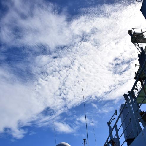
Now we have started our third day in tropical waters. The first two days we had a kind of chase. The trough that I have already described has been moving north with its cloud bands, and we followed in its track.

On Wednesday, the sequence of satellite images could give the impression that it will move away from us, but it kept visible ahead (Image 3).

As expected it slowed further down while weakening, so Thursday afternoon we finally reached its most southern clouds (nicely seen during sunset, right part of Image 4).

On the satellite image of Thursday afternoon, however, it seemed that on our track the lower clouds below the high cirrus shield have already dried away (Image 5).

But on Friday night we experienced some first showers, with some lightning - at least those of us that were awake around 02:00 or 05:00 (local time). But the corresponding clouds were still impressive on Friday morning, even when they lay behind us (Image 6).

Just to note, another interesting observation we made on Wednesday. The tropics greeted us with some nice convective systems in the area, but on the first view they seemed to be wrong: they were sloped against the wind.
Normally, as I learned decades ago for my gliding licence, the slope of a convective cloud shows from base to top the direction of the wind. The explanation here was quite simple and good to see it in the data of the radiosonde: the wind decreased strongly with height, so the cloud bases were blown away from under their tops.
Another thing we are curious about is the development of the sea during the weekend when we will reach the area of the southern trade winds, and we expect a corresponding sea and swell from southeast. On the other hand, on the northern hemisphere a storm low is currently passing the Atlantic to the east. This will establish an unusually high swell that will proceed far to the south, reaching us during the weekend somewhere around 10°S as a very long swell from the north.
The different models are not very unique above the height we should expect (between 1.5m and 3.5m at the moment), but all see the relevant period of the sea state beyond 15 seconds. So it will be interesting to see how such a very long swell from ahead and a second swell more or less from aft will interact.
Into the Engine Room
With the expectation that watching clouds all the time might be a little bit boring, the chief engineer gave us the chance to have a look into the engine hall of the vessel on Thursday. So the eight scientists met to climb down to the basement of the ship.

It was an impressive visit: hot, loud, huge and complicated for the untrained eye and all several meters below the water line. And in every explanation you could feel the pride that the crew have for their ship.
We got so much information, that I would like to send you to the website of the Alfred Wegener Institute here and here where you can find out about the ship as well - otherwise I would have enough stuff for the remaining cruise.