Weather conditions in the Arctic
The MOSAiC expedition continues and the students following the mission’s progress have delivered blog number five.


Read on to hear all about the weather conditions in the Arctic during October 2019.
15 March 2021
28 April 2020
Blog five
Satellite measurements explained
Authors: Anna Helle, Tobias Kern and Alexander Scholz

Our group has been dealing with the Arctic weather conditions on the student polar project. This latest blog post takes a look at the weather conditions on 28 October 2019 at 00:00 UTC.
We worked with the values of determined meteorological parameters based on reports from the Polarstern, satellite imagery and different ICON weather model predictions.
It should be kept in mind that the polar night was occurring in the North Pole during this time. For this reason, we could not use satellite imagery containing channels in the visual wavelength range as part of our weather analyses, therefore, only infrared images were available.
Decoding of SYNOP
The surface synoptic observations (SYNOP) report “FM-13 SHIP” for 28 October 2019 at 00:00 UTC contains information on weather observations that were made on board the Polarstern. The recorded wind speed is 8 m/s, coming from a direction of 120°. The air temperature on board the Polarstern is -20.2°C, while the dew point temperature is -22.3°C. The mean sea level air pressure is 1024.4 hPa.
Interpretation of the sounding


Now, let’s take a closer look at the sounding from 28 October 2019 00:00 UTC (seen in the two images above). The first thing that stands out is the strong inversion near the ground. You can see a very fast warming in the first metres and a weaker climb in temperature later. This strong inversion is caused by the absence of solar radiation during the polar night. The surface is cooling down over a long period of time, because there is continuous long-wave radiation coming off the Earth.
The atmospheric radiation caused by the layer clouds, which can be seen at different heights, is not strong enough to compensate for this. Close to the ground, the spread between the temperature and the dew point is too big, so there is no fog, which can also be seen on the webcam photo. A reason for this could also be the very high wind velocities on the ground or falling precipitation from stratus clouds.
The inversion layer is very damp, because there is a high level of damp surrounding the ship (ice and water), and because of the cold temperatures, there is not much water steam available to have a high relative humidity. Another reason for the damp inversion layer could be the stable layering – there is no exchange with higher air masses. The subsiding inversion at about 860 hPa is the reason. It came about when air subsided, caused by a local high. The air is subsiding, and because of its compressibility, lower air is subsiding less than the higher air, so these higher air masses are warming more than the low air masses.
Warm air can take up more humidity than colder air, so the spread is getting bigger at the beginning of this inversion. As a consequence, clouds disperse, humidity decreases and the sight gets better above the inversion.
All in all, it stabilises the weather. A second subsiding inversion can be seen at about 630 hPa. In general, the air is very damp and also in higher levels, so thick layers of clouds are the consequence, even if there are dryer areas between those layers.
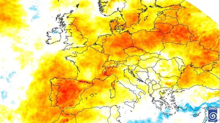
Sea ice concentration

In the graphic above (which is calculated from satellite imagery), you can see the extent and concentration of sea ice in the Arctic on 27 October 2019.
The area from 82°N to the North Pole is completely covered by ice. This means that the Polarstern (small black rectangle) between 85°N and 86°N is well within the ice cover. To the south, the sea ice extends to Spitzbergen, Franz Josef Land and Severnaya Zemlya where it also reaches Russian mainland. Then, the ice boarder retreats back northwards to 78°N again to extend and reach land at Banks Island, also extending to the Canadian mainland and Greenland more easterly.
Interpretation of infrared (IR) 10.76 satellite image

This image was taken via the satellite’s Visible Infrared Imaging Radiometer Suite (VIIRS) and is displaying the IR 10.76 μm wavelengths. It basically shows the temperature of the objects on a grey scale. Bright means colder (less radiation) and dark means warmer (more radiation) temperatures as the image is inverted.
Something special about the Arctic area is that the iced ground is often colder than low or even mid-level clouds, as can also be seen in the sounding.
Most of the area around the pole is displayed in a uniform mid-grey colour, suggesting stratiform low- to mid-level clouds with varying thickness. These can also be seen above the Polarstern.
North and east of the Polarstern there is a brighter, more structured area. This means that it is colder and the structures can be read as textures on the ice, leading to the conclusion that cloudless ground can be observed here. South of the pole at around ca. 87°N and 150°E there is an area where you can see clouds as well as ground structure. Therefore, they are probably high and thin cirrus clouds where it is possible to see through them.
More to the south-east, between Kola Peninsula and Nowaja Zemlya, more cumulus-looking clouds above a dark and warm background (water) can be observed. This leads to the conclusion that convection is present there.
Temperatures of the Arctic area from a satellite image

This image is the same as the previous IR 10.76 μm but with a colour scheme applied to it to better show the ground and cloud temperatures. The scheme covers a temperature range from -5° to -35°C and therefore most temperatures are detected. The difference between the colours are 3K. The colours of the cloud-free ground area around the pole are black, dark blue, light blue and purple. This means temperatures between -23° and -35°C. South-east of the pole there are even cooler temperatures indicated by light grey colours.
The North Pole itself is covered by clouds resulting in a temperature between -17° and -20°C, indicated by a dark green colour. The same colour and therefore temperature values can be found above the Polarstern (between 85°N and 86°N, indicated with a small black rectangle in the image).
The height of the cloud tops there can be estimated at about 1.5km by using the temperatures and the sounding. The closest ground not covered by clouds is between -26° and -29°C.
The SYNOP reports -20.2°C for the Polarstern.
The aforementioned area between the Kola Peninsula and Nowaja Zemlya showing convective clouds also shows colours of warmer temperatures ranging from orange (-17° to -14°C) in the colder areas to dark grey (more than -5°C) in the warmer areas, probably due to being an ice-free sea surface.
Analysis of the 500 hPa geopotential chart from the ICON weather model

This model prediction map shows the air temperature on the 500h Pa pressure area and contains additional information on the geopotential height.
There is a relationship between air temperature, geopotential height and air pressure. Cold temperatures are associated with low geopotential, while warm temperatures are associated with high geopotential.
Due to the higher density of colder air, the 500 hPa area in cold temperature areas is lower than in warm air masses. The forecast shows slightly warmer temperatures for the Polarstern than in the surrounding area. An area with a high geopotential located in a southern direction of the 180th degree of longitude influences the temperatures.
The temperatures above the Polarstern range from -30°C to -32°C. The 500 hPa pressure area lies between 528 and 536 gpdm (geopotential decometre) above sea level. The minimum temperatures above the North Pole range from -42°C to -44°C for the Canadian Queen Elizabeth Islands and the Russian island Novaya Zemlya. At these points, the geopotential height is 528 gpdm and 496 gpdm respectively.
Thanks again to the group following the Polarstern’s progress and for this very informative look at Arctic weather conditions! If you’re interested in finding out more about this project, you can read our earlier blog posts or visit the MOSAiC expedition’s dedicated website here.