06 January 2026
06 January 2026
About
Freshwater is a vital yet limited resource, and monitoring river discharge is essential for managing water availability, detecting climate trends, and supporting a wide range of hydrological applications. However, traditional in-situ monitoring networks are in decline, especially in remote and data-scarce regions. To address this gap, the GLOBAL RIVER DISCHARGE study explores the combined use of satellite altimetry and multispectral optical observations to estimate river discharge at a global scale. Building on previous research and recent advances in satellite technology, the study aims to deliver a pre-operational product with daily temporal resolution across more than 300 globally distributed river sites.
Objectives
The main objective of the GLOBAL RIVER DISCHARGE study is to generate a global, high-resolution river discharge product using multi-mission satellite data. Specifically, the study aims to:
- develop a satellite-based algorithm that integrates radar altimetry and optical reflectance indices to estimate daily river discharge;
- apply the algorithm to more than 300 river sites worldwide, covering a diverse range of hydrological and climatic conditions;
- validate the discharge estimates against in-situ and modelled data to assess their accuracy and reliability;
- evaluate the utility of the dataset for hydrological applications, including water resource management and climate analysis, particularly in ungauged basins;
- provide a roadmap for the future development of Fiducial Reference Measurements (FRMs) to support long-term monitoring of river discharge from space.
Overview
Introduction
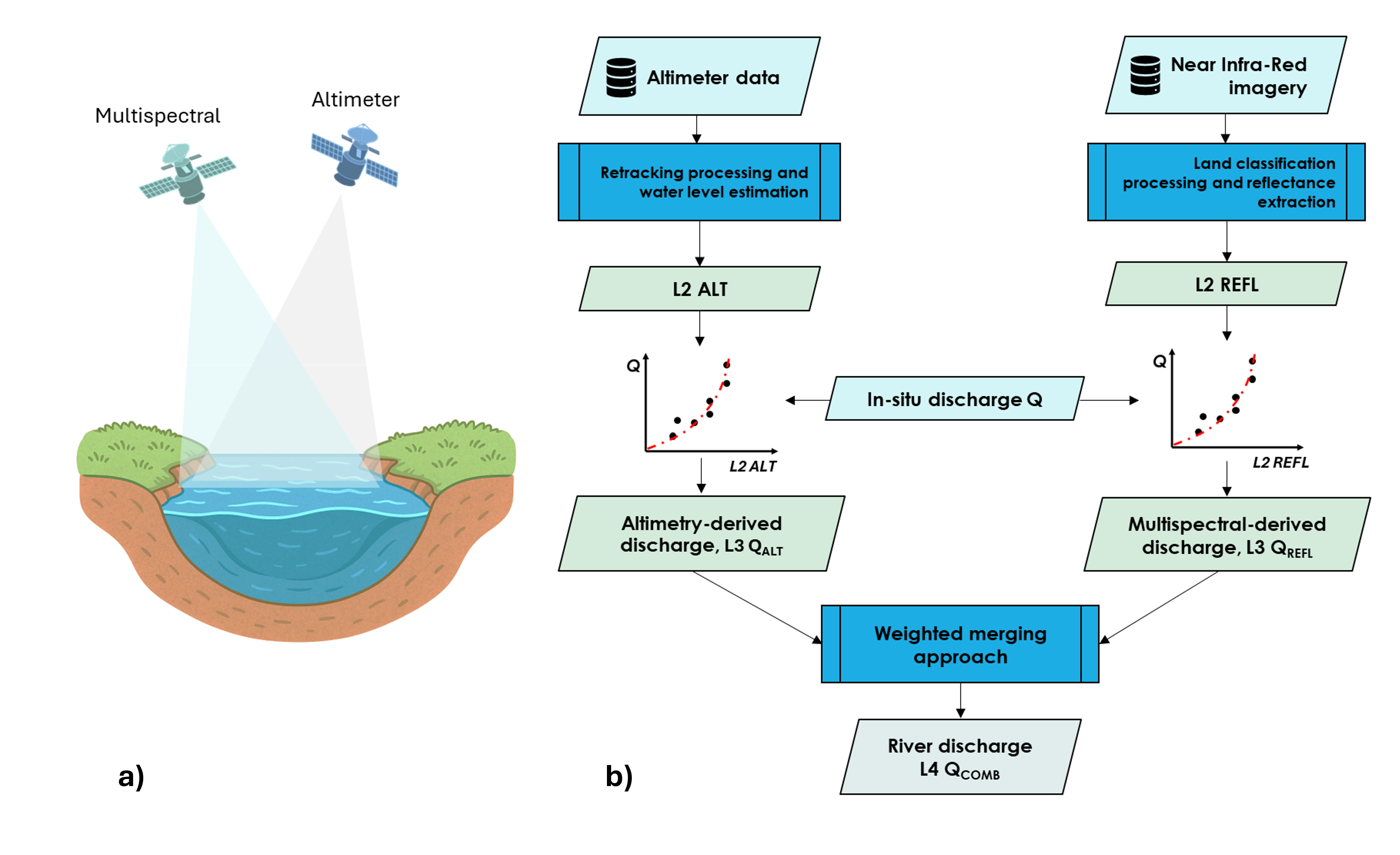
Monitoring river discharge is critical for understanding hydrological processes, managing freshwater resources, and assessing climate variability. However, the decline of in-situ gauging networks and the limited availability of data in remote or conflict-prone regions have created significant observational gaps. Satellite remote sensing offers a unique opportunity to address these challenges by providing consistent, wide-area measurements of inland water bodies. The GLOBAL RIVER DISCHARGE study responds to the need for an operational, high-resolution global river discharge dataset. It leverages the complementary capabilities of radar altimetry (e.g., Sentinel-3, Sentinel-6, SWOT) and optical sensors (e.g., Sentinel-2, Sentinel-3 OLCI, MODIS) to estimate discharge with improved temporal resolution and spatial coverage.
Methodology
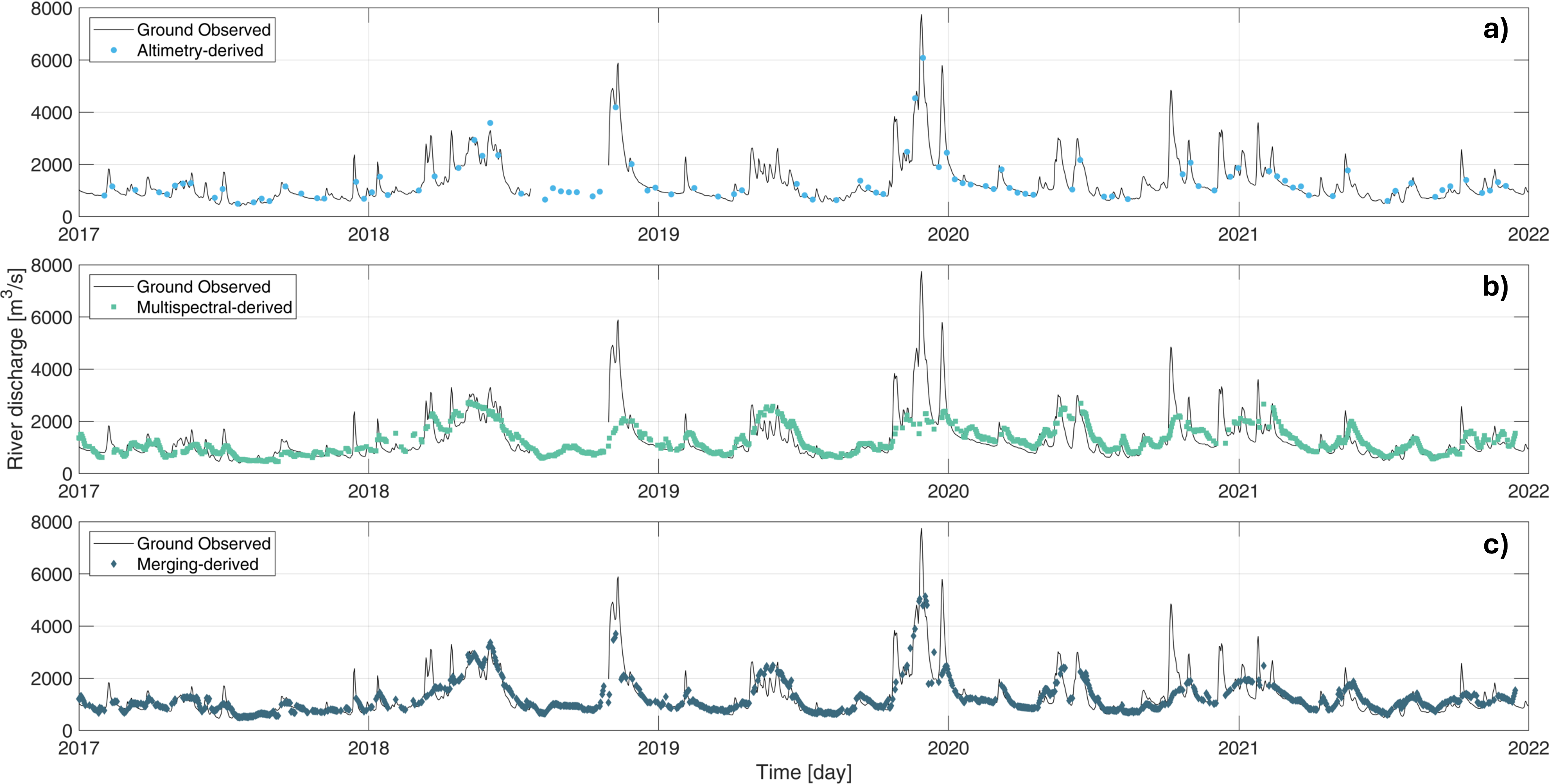
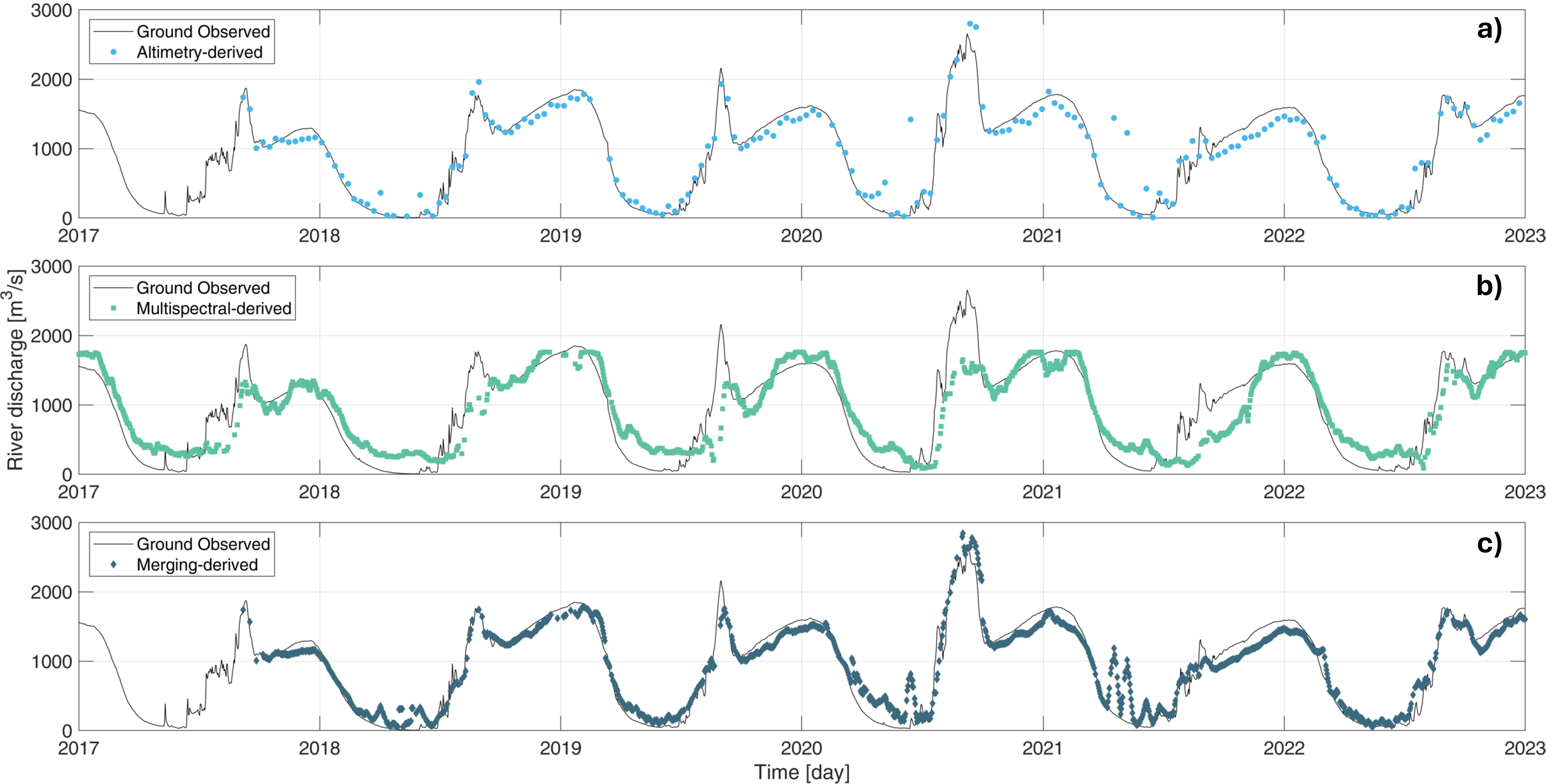
The study follows a multi-step approach that considers the selection of over 300 global river sites representing diverse climatic and morphological regimes. Over these sites, altimetry data are pre-processed and integrated in a multi-mission framework to derive temporally densified water level time series (L2 ALT). Reflectance indices from multispectral imagery are then extracted from multiple satellite missions to serve as proxies for surface flow conditions (L2 REFL).
Finally, the river discharge algorithms are implemented using single-sensor inputs ((L3 QALT, L3 QREFL) and multi-sensor integration (L4 QCOMB), which combines water level and reflectance-based flow proxies. A validation process against ground based and modelled discharge data is carried out using standard hydrological performance metrics.