Metop A Spot

Metop Second Generation - Instruments


Ten state-of-the-art instruments will improve weather forecasts and extend climate records

Metop A Spot
Metop A Spot

From measuring temperature and water vapour, to imaging fine particles, to detecting wind across the sea surface, the instruments on board Metop Second Generation satellites will collect crucial data.

Last Updated

19 March 2024

Published on

16 November 2022

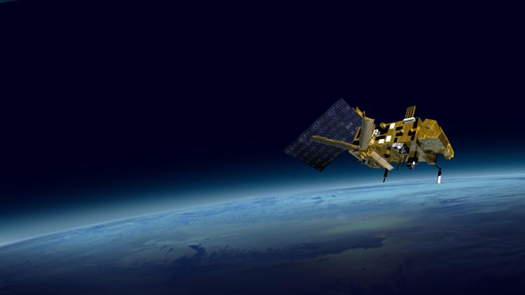
Metop - Second Generation (Metop-SG) satellites are EUMETSAT’s next-generation polar-orbiting satellites. This mission will provide long-term continuity in measurements of the atmosphere, ocean, and land surfaces across the globe.

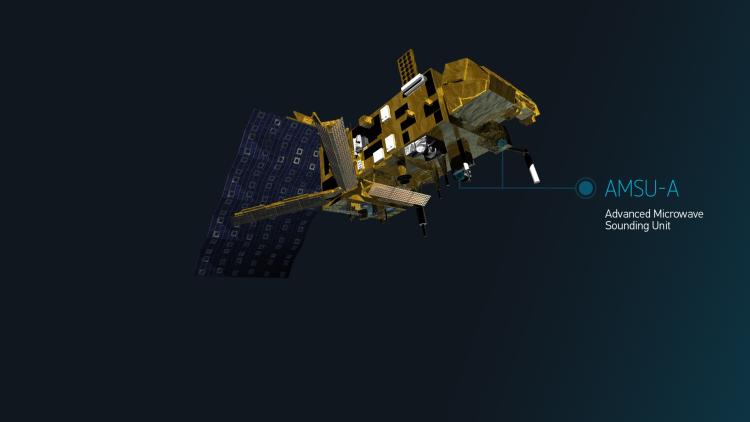
Its suite of 10 state-of-the-art instruments that measure atmospheric temperature and humidity, monitor air quality, detect wind across the ocean surface, and much more, will provide observations with substantially better spatial resolution, coverage, and accuracy than the first generation of Metop satellites. Crucially, these improved observations will enable meteorologists to improve life-saving weather forecasts and extend climate records. One particularly innovative instrument, the Ice Cloud Imager, will make its debut flight on Metop-SG satellites, offering a never-before-seen glimpse into the detailed microphysics of clouds.

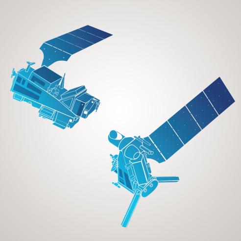
A complete constellation of Metop-SG satellites consists of one optical imaging and sounding satellite and one microwave imaging and sounding satellite.

Metop Second Generation A instruments

Infrared Atmospheric Sounding Interferometer – New Generation

The Infrared Atmospheric Sounding Interferometer – New Generation (IASI-NG) is a passive infrared sounder that will provide radiance spectra measurements of temperature, humidity, clouds, greenhouse gases, aerosols, and trace gases in the Earth’s atmosphere.

The frequent observations delivered by IASI-NG will be essential for numerical weather prediction at global and regional scales, enabling specialists to deliver more accurate weather forecasts up to 10 days ahead.

IASI-NG data will contribute to nowcasting applications, providing data relevant for monitoring atmospheric instability – especially impactful at higher latitudes, where coverage from geostationary satellites is sparser.

Datasets will also benefit climate studies and air quality and emissions monitoring through global observations of ozone, carbon dioxide, carbon monoxide, methane, ammonia, nitrogen dioxide, and other trace gases.

IASI-NG has direct heritage from the IASI instrument on board Metop satellites, with opportunities for improved satellite data products thanks to more spectral channels, an increase in spectral sampling, and a reduction in radiometric noise.

The development of IASI-NG is led by the French National Centre for Space Studies (CNES), who have contracted Airbus DS for the design, construction, and testing.

Facts and Figures

  • Dimensions: 6.5m x 13.7m x 3.5m
  • Mass in orbit: 4,400kg
  • Power: 3.0kW
  • Payload mass: 3,600kg
  • Orbit: Sun-synchronous, 835km altitude
  • Orbit revolution: 101 minutes
  • Repeat cycle: 21 days
  • Design lifetime: 7.5 years

Microwave Sounder

The Microwave Sounder (MWS) is a total power radiometer that will deliver calibrated and geolocated atmospheric temperature and water vapour sounding data by measuring the brightness temperature – or the intensity of electromagnetic energy – at various altitudes and in all weather conditions. MWS will also provide observations of cloud, snow, sea ice, and surface phenomena.

MWS data will benefit numerical weather prediction, offering a significant upgrade to input data for operational services. For example, the instrument is expected to make impressive contributions to all-sky radiance assimilation, which integrates observations of current conditions from the atmosphere, oceans, land, and cryosphere into predictive models.

Data from the instrument will also contribute to nowcasting at regional scales, especially at higher latitudes where coverage from geostationary spacecraft is sparser. 

MWS has heritage from sounding microwave instruments on board current Metop series and NOAA satellites and will also feature new channels that will enhance observations of the lower troposphere and of ice clouds. The instrument will enable the continuation of long-term climate monitoring services and contribute to products supporting hydrological and land surface analysis applications.

MWS is designed and developed by Airbus DS, leading a core team of industrial partners.

METImage

METImage is a multi-spectral imaging radiometer that will provide observations of the Earth’s outgoing radiation for meteorological and climate applications in both visible and infrared frequencies. METImage data will be particularly important for numerical weather prediction, nowcasting, and climate monitoring.

METImage will also support a wide range of other applications, including oceanography, hydrology, land surface analyses, and aerosol and air quality monitoring. The instrument will support sounders on board Metop Second Generation A satellites for geolocation, cloud characterisation and correction of spectral response.

On board calibration of solar channels and an enhanced maximum spatial resolution of 500m enable will enable specialists to develop enhanced satellite data products using METImage data. This includes those relating to parameters such as cloud size and their microphysical properties, fog detection, sea surface temperature, surface albedo, vegetation, sea ice, snow cover, soil moisture, fire monitoring, aerosols, volcanic ash, winds, and polar atmospheric motion vectors.

METImage observations will be delivered in 20 spectral channels, spanning 443 nanometres to 13.345 micrometres – a substantial upgrade on the highly successful Advanced Very High Resolution Radiometer on board current Metop satellites.

METImage is developed by the German Aerospace Centre (DLR), who have contracted Airbus DS for the design, construction, and testing.

You can find out more about the Visible-Infrared Imaging instrument here.

Multi-viewing Multi-channel Multi-polarisation Imager

The Multi-viewing Multi-channel Multi-polarisation Imager (3MI) is a unique passive optical radiometer, whose objectives are to provide atmospheric aerosol and cloud imagery for climate monitoring, air quality forecasts, and numerical weather prediction.

The instrument’s unique combinations of wavelengths and polarisations will provide detailed and complementary information on all aerosol parameters critical for climate records, including aerosol optical depths, particle types and sizes, refractive index, height index, and sphericity.

3MI will enable observations of the same target area from 14 different viewpoints and datasets will increase the accuracy of weather forecasts, for instance by enabling specialists to distinguish between ice and water clouds, and between salt and dust particles over the ocean.

3MI will also provide measurements of incoming and outgoing radiation at the top of the atmosphere, as well as multi-angle, multi-wavelength, and multi-polarisation observations relevant to monitoring volcanic ash, water vapour, ocean colour, soil conditions, and surface albedo. 

3MI is developed by Leonardo (formerly SELEX) in Florence, Italy who is leading a large team of more than 10 subcontractors.

Radio Occultation

The Radio Occultation (RO) sounder mission will provide atmospheric temperature and humidity measurements that will be of great benefit to numerical weather predictions and climate monitoring.

By analysing how Global Navigation Satellite System (GNSS) signals are refracted through the atmosphere, RO will enable specialists to infer temperature and water vapour measurements, as well as data relevant for monitoring the planetary boundary layer, the height and structure of the tropopause, and surface pressure.

GNSS signals provide global coverage, high precision, high vertical resolution, long-term stability, and all-weather viewing. RO datasets will also present opportunities to monitor space weather as they enable measurement of electron densities and profiles in the middle and high atmosphere.

RO has direct heritage from the Global Navigation Satellite System Receiver for Atmospheric Sounding (GRAS) instrument on board current Metop satellites. It will deliver observations that are more accurate and with higher spatial and temporal resolution, as they will enable specialists to acquire, observe, and track signals from new GPS and Galileo navigation system constellations.

The RO sounding mission is developed by RUAG Space, Sweden.

Copernicus Sentinel-5

The Copernicus Sentinel-5 mission is a high-resolution spectrometer system operating in the ultraviolet to infrared range, with seven different spectral bands. Sentinel-5 comprises an ultraviolet visible near-infrared shortwave spectrometer, complemented by data provided by other instruments on board Metop Second Generation A satellites.

The instrument is part of the constellation of missions that serve the needs of the Copernicus programme, the Earth Observation component of the European Union’s space programme.

Sentinel-5 will provide detailed vertical measurements of the total atmospheric content of ozone and the concentration of gases such as ozone, sulphur dioxide, nitrogen dioxide, water vapour, methane, carbon dioxide, carbon monoxide, bromine oxide, formaldehyde, and glyoxal, as well as volcanic ash and aerosols like dust and salt.

These datasets will enhance atmospheric composition monitoring and support air quality forecasts produced by the Copernicus Atmospheric Monitoring Service. Data will also benefit applications such as climate monitoring, numerical weather predictions, nowcasting, aviation services, UV warnings, and studies of the formation of holes in the ozone layer. 

Sentinel-5 observations will continue and enhance the legacy of the Global Ozone Monitoring Experiment–2 instrument on board current Metop satellites and will be highly complementary to observations made by the Sentinel-4 instrument, which will feature on geostationary Meteosat Third Generation sounder satellites.

The development of Sentinel-5 is carried out by Airbus DS (Germany). Many European industries have contributed to the subsystems.

UV/VIS/NIR/SWIR Sounding (COPERNICUS Sentinel-5 UVNS)

The UV/VIS/NIR/SWIR Sounding instrument will measure trace gases and aerosols (fine particles) in the atmosphere, contributing to the improved monitoring of air quality, changes in the ozone layer, and emissions from wildfires. This mission will continue the record of climate data collected by the Global Ozone Monitoring Experiment-2 on Metop-B and Metop-C with drastically improved spatial resolution.  

Metop Second Generation B instruments

Ice Cloud Imager

The Ice Cloud Imager (ICI) is a conically scanning radiometer that will help to fill in gaps in microwave observations and enrich global observations of ice clouds, such as cirriform clouds. ICI will enable specialists to gain a more comprehensive understanding of critical properties for validating and representing ice clouds in climate and numerical weather prediction models.

Ice clouds typically blanket up to a third of the planet at any point in time, and they therefore play a critical role in regulating the Earth’s climate and weather patterns. ICI is the first instrument of its kind to operate in both millimetre and submillimetre frequencies, making the instrument sensitive to both large and small ice crystals, as well as water vapour.

ICI will enable specialists to generate improved cloud products such as those detailing ice cloud altitudes and radius; the amount of ice as measured vertically in the atmosphere – known as ice water path; to characterise hydrometers – such as cloud ice, soft hail, and snow; and to make predictions about mean ice crystal diameter and ice mass height.

Observations will be highly complementary to other microwave sounding instruments on Metop Second Generation satellites, with combined datasets also set to contribute to more accurate and frequent precipitation estimates for hydrology applications.

ICI Is built by Airbus DS (Spain).

Facts and Figures

  • Dimensions: 6.5m x 15.8m x 3.5m
  • Mass in orbit: 4,110kg
  • Power: 2.6kW
  • Payload mass: 3,370kg
  • Orbit: Sun-synchronous, 835km altitude
  • Orbit revolution: 101 minutes
  • Repeat cycle: 21 days
  • Design lifetime: 7.5 years

Microwave Imager

The Microwave Imager (MWI) is a conically scanning total power radiometer that measures aspects such as precipitation, temperature, cloud, water vapour, sea ice and snow cover. MWI will serve operational meteorology, climate applications, oceanography, and sea ice, snow, and land surface observations.

The interaction of microwave radiation with clouds and precipitation makes it possible to infer microphysical properties of clouds such as the amount of water they contain and the size of droplets. When used in combination with the Microwave Sounding Instrument and the Ice Cloud Imager, data from MWI will contribute towards improving precipitation estimates, particularly in short range forecasts.

MWI features 26 channels, and its broad spectrum of high-resolution observations will enable the creation of cloud and precipitation products supporting numerical weather predictions and nowcasting. Datasets will also contribute to observations of sea surface wind speeds, land surface analysis, and climate records, providing continuity to instruments on current missions operated by EUMETSAT and partner organisations. 

MWI will be developed by Carlo Gavazzi Space (CGS) S.p.A., Italy, a unit of OHB AG, under contract from Airbus DS.

Scatterometer

The Scatterometer (SCA) is a real aperture pulsed imaging radar that will provide valuable data for numerical weather prediction, nowcasting, ocean state forecasts, and land, sea ice, and climate services.

One of SCA’s main applications will be to measure sea surface roughness, which correlates closely with wind speed and direction over the ocean. To do this, the instrument will transmit pulses of microwave energy, as a radar, towards the Earth’s surface and record echoes that are ‘backscattered’ from waves on the ocean surface.

Backscatter signals are also highly useful for observing the Earth’s land surface, and SCA presents opportunities to enhance satellite data products relating to soil moisture, leaf area indices, snow, and sea ice. SCA will provide measurements in all weather conditions, with even greater spatial resolution and coverage than its highly successful predecessor, the Advanced SCATerometer (ASCAT) on current Metop satellites.

SCA will also empower specialists to observe higher wind speeds than before and support tracking of tropical and extra-tropical storms.

The SCA instrument is being developed by Airbus DS (Germany and Spain).

Radio Occultation

The Radio Occultation (RO) sounder mission will provide atmospheric temperature and humidity measurements that will be of great benefit to numerical weather predictions and climate monitoring.

By analysing how Global Navigation Satellite System (GNSS) signals are refracted through the atmosphere, RO will enable specialists to infer temperature and water vapour measurements, as well as data relevant for monitoring the planetary boundary layer, the height and structure of the tropopause, and surface pressure.

GNSS signals provide global coverage, high precision, high vertical resolution, long-term stability, and all-weather viewing. RO datasets will also present opportunities to monitor space weather as they enable measurement of electron densities and profiles in the middle and high atmosphere.

RO has direct heritage from the Global Navigation Satellite System Receiver for Atmospheric Sounding (GRAS) instrument on board current Metop satellites. It will deliver observations that are more accurate and with higher spatial and temporal resolution, as they will enable specialists to acquire, observe, and track signals from new GPS and Galileo navigation system constellations.

The RO sounding mission is developed by RUAG Space, Sweden.

Advanced Data Collection System Argos-4

The Advanced Data Collection System Argos-4 (ACDS-4) will contribute to the Argos worldwide location and data collection system dedicated to studying and protecting the environment. Argos provides environmental monitoring from remote stations, either fixed or mobile, fitted with an Argos transmitter, including surface instruments, buoys, ships, balloons, and airborne data collection platforms.

Sensors on Argos platforms collect data on everything from atmospheric pressure, sea temperature, and river water levels to animal heart rates, and observations relevant for safety warnings. Data from ADCS-4 will be provided directly to the Argos centre for onward processing and dissemination to the user community.

Flying the Argos system on board polar-orbiting satellites provides worldwide coverage.

ADCS-4 is provided by the French National Centre for Space Studies (CNES).