16 April 2024
08 April 2024
About
The purpose of the study was to reduce the uncertainties in the desert vicarious calibration system currently in place at EUMETSAT. This was achieved by: i) improving the spectral description of the surface Bi-directional Reflectance Distribution Functions (BRDF) characterising the desert sites serving as pseudo-invariant calibration sites (PICS) within the EUMETSAT vicarious calibration system; and ii) improving the description of the aerosol model utilised in the radiative transfer model.
The EUMETSAT vicarious calibration system is designed to cover the reflective portion of the solar spectrum, so that it can support multi-mission vicarious calibration activities for the imaging instruments operated by EUMETSAT. Currently, the system supports the following instruments:
- SEVIRI (Spinning Enhanced Visible Infra-Red Imager), on the Meteosat Second Generation platforms.
- FCI (Flexible Combined Imager) and LI (Lightning Imager), on the Meteosat Third Generation Imager platforms.
- OLCI (Ocean and Land Colour Imager) and SLSTR (Sea and Land Surface Temperature Radiometer), on the Sentinel-3 platforms. Currently, two instances are in operations.
- AVHRR (Advanced Very High Resolution Radiometer) on the Metop satellite, constituting the first generation of the EUMETSAT Polar System.
- METimage (Meteorological Imager) and 3MI (Multi-viewing Multi-channel Multi-polarisation Imager), on the upcoming Second Generation of the EUMETSAT Polar System.
- MAP (Multi-Angle Polarimeter) and CLIM (Cloud Imager), on the upcoming CO2 Monitoring mission.
Retroactively, the vicarious calibration system is applied to past instruments, such as MVIRI (the first-generation Meteosat Visible Infra-Red Imager).
The vicarious calibration system may also be extended to other instruments, such as GSICS references for reflective solar bands, like VIIRS (Visible/Infrared Imager Radiometer Suite) on the NOAA-20 polar platform. This extension enables EUMETSAT to conduct internal assessments of uncertainties.
Objective
The objectives of the project were as follows:
- Objective 1: Improving the spectral description of the four-parameter Rahman-Pinty-Verstraete (RPV) model to characterise the BRDF of a subset of Pseudo Invariant Calibration Sites (PICS) used in EUMETSAT’s vicarious calibration system. Based on an initial set of spectrally resolved RPV parameters, a mechanism to improve this dataset was implemented by making use of external observational datasets.
- Objective 2: Improving the aerosol model, particularly in terms of its optical properties, for integration into the radiative transfer model utilised as a calibration reference for the aforementioned PICS. The previous aerosol model was the default background desert model in 6S/6SV.
- Objective 3: Conducting an uncertainty assessment of the newly defined components within the radiative transfer calculation. This assessment focused on evaluating the impact of terrain versus pixel resolution, as well as considering the influence of illumination and viewing conditions on the calibration process.
Overview
An analysis was conducted at two different spatial resolutions (20x20 km and 50x50 km) on the list of PICS employed within EUMETSAT’s vicarious calibration system. The aim was to identify a subset of targets that could serve as primary reference calibration sites. Following an examination of terrain data and meteorological variables, including precipitation records, six sites were selected for further consideration (as listed in Table 1):
Table 1: List of PICS retained for the detailed BRDF analysis.
| Name | Long. | Lat. | Elev. 20km | Elev. 50km |
|---|---|---|---|---|
| algeria5 | 2.24 | 31.16 | 524.34 (31.194) | 508.59 (21.597) |
| arabia2 | 51.63 | 20.19 | 183.46 (5.565) | 185.16 (14.758) |
| libya4 | 23.42 | 28.67 | 129.70 (11.178) | 123.99 (11.424) |
| niger2 | 10.60 | 21.33 | 517.94 (8.086) | 519.82 (20.199) |
| egypt1 | 26.22 | 26.61 | 279.07 (12.3) | 279.07 (16.1) |
| sudan1 | 27.70 | 21.40 | 383.26 (8.0) | 383.22 (14.5) |
| Note: values between brackets are standard deviations of the terrain elevation over the area | ||||
For these sites, Level 1 imagery was collected from a range of Earth observing satellites, including Aqua and Terra MODIS, Sentinel-2A MSI, Sentinel-3A and B OLCI, Meteosat-11 SEVIRI and PARASOL POLDER. Subsequently, this dataset underwent processing using the Rayference CISAR algorithm to retrieve the Rahman-Pinty-Verstraete (RPV) model parameters for the respective channels of the various instruments (as shown in Figure 1 for the case of Libya4).
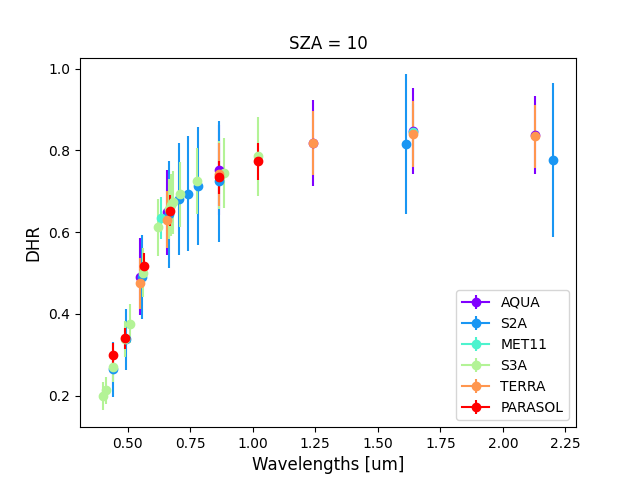
The Bidirectional Reflectance Factor (BRF) was inferred in the principal plane over a set of zenith angles from this set of RPV parameters. In a secondary step, these BRF values were spectrally interpolated across the entire spectrum from 0.35 and 2.5 mm, using a selection of reflectance spectra from the PICSAND database. Following this, the BRF spectra underwent inversion using the RPV Model Inversion Package to retrieve the spectrally described RPV parameters. A bias correction was applied to the results to account for outdated molecular concentration data such as CO2 and CH4 in CISAR. Figure 2 illustrates the result of this data processing.
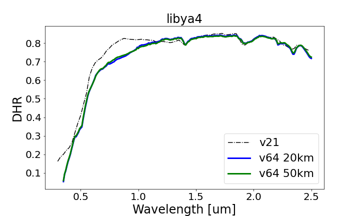
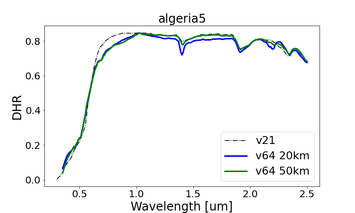
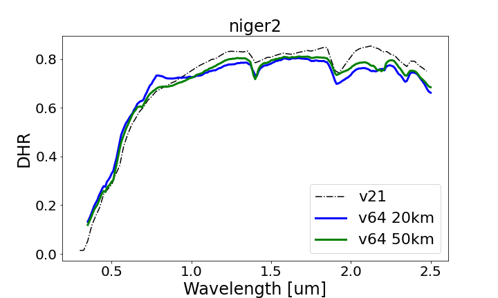
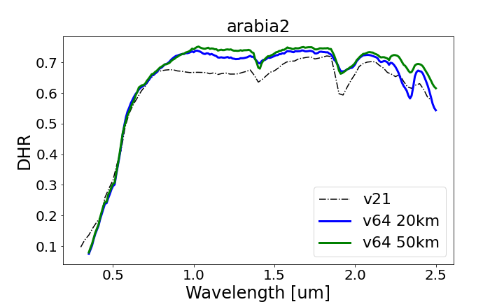
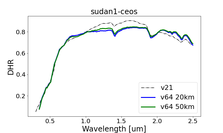
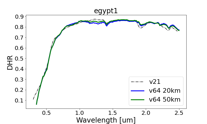
Figure 2: DHR over the six selected sites. The black dashed line represents V21 (the old RPV parameters set used as first guess), while the green and blue solid lines represent the v64 (newly derived) at 50 and 20 km resolutions respectively.
In addition to the spectral description of the surface BRDF of the selected sites, an important objective of the study was to improve the description of the atmospheric composition for those sites, and in particular to revisit the description of the aerosol model simulating the desert dust over those PICS. An approach was proposed to derive the aerosol microphysical properties from the analysis of AERONET V3 inversion data collected at the selected targets. These properties include:
- The fine mode radius and its distribution;
- The coarse mode radius and its distribution;
- The percentage of spherical particles;
- The real and imaginary refractive index at the AERONET wavelengths.
In a subsequent step, the refraction index was extrapolated across the entire spectral range of interest, spanning from 350 nm to 2500 nm, and the corresponding single scattering properties were calculated from these microphysical properties. This process resulted in the establishment of two new aerosol models over the Saharan and Arabian deserts, which will be integrated into the radiative transfer models used within the EUMETSAT desert vicarious calibration system.
An important aspect of the project was to evaluate the overall uncertainty of the reflectance simulations performed with the new RPV parameters and aerosol models provided by the previous work packages. In particular, the assessment focussed on:
- Estimating the uncertainty of a 1D Radiative Transfer Model (RTM) with respect to the given parameters and assessing the correlations between them. This analysis utilised the 6SV1.1 Radiative Transfer Model, excluding light polarization simulation.
- Evaluating the impact of the surface 3D effects on the simulated Top-Of-Atmosphere BRF. For this evaluation, the Digital Elevation Model (DEM) from the Copernicus DEM GLO-30 dataset was used and the simulations were performed with the Eradiate RTM.
The magnitude of the uncertainties determined in the initial part (1D) were compared with the 3D effects. It is important to note that under the 1D RTM assumption the RPV model accounts for both micro-scale factors (due to light scattering by sand) and macro-scale influences (due to surface topography 3D effects).
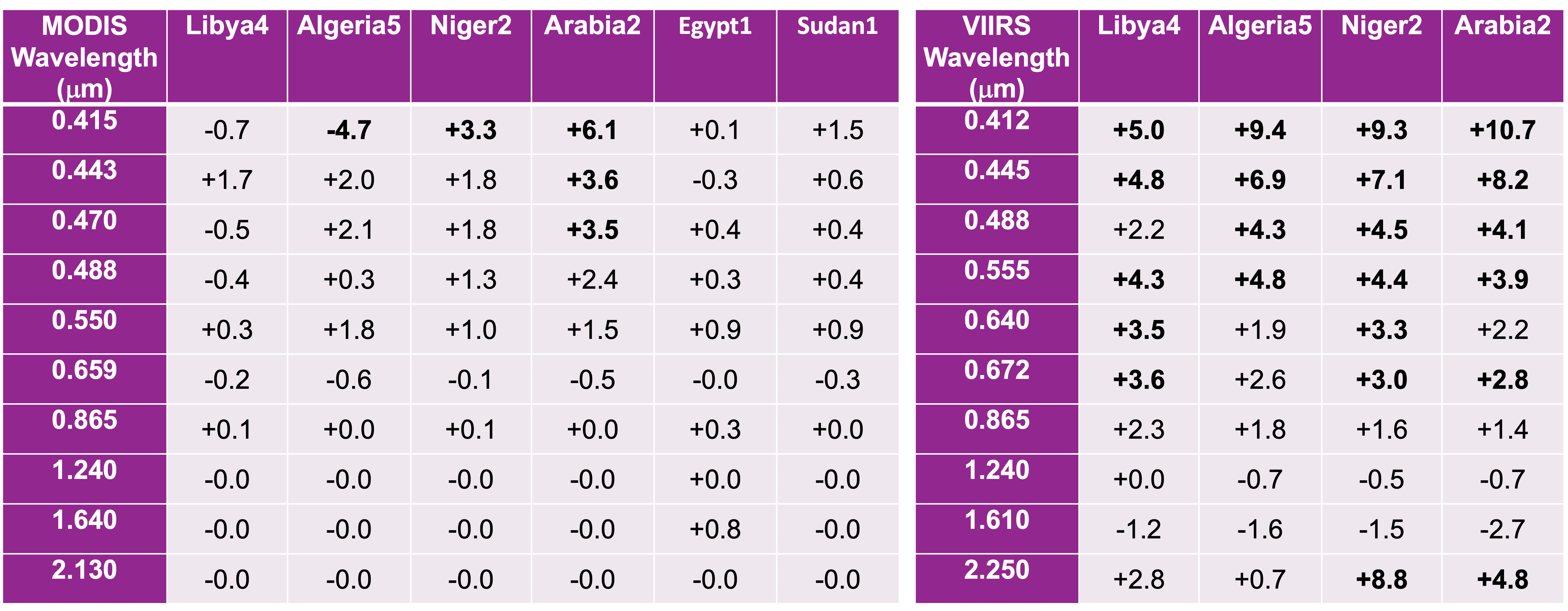
Finally, the overall accuracy and precision of the simulated calibration reference were assessed using the reference instruments VIIRS/JPSS1 and MODIS/Aqua (Calibration References or CR). One year of data was simulated over all targets using the RTMOM RTM (as implemented at Rayference) with the newly derived RPV parameters and aerosol models serving as input to the simulations. Additionally, one year of data was simulated with the 3D RTM Eradiate over Libya-4.
The accuracy evaluation was based on the comparison between the simulated and actual reference instruments acquired over the selected PICS accounting for the estimated CR uncertainty and radiometric accuracy of the selected instrument. Evaluation against Aqua MODIS showed a relative bias of less than 2.5% over all targets for wavelengths longer than 488 nm, consistent with previous findings (Govaerts, 2019). However, the bias against VIIRS showed larger values, which would require further investigation. The discrepancy between MODIS and VIIRS biases could stem from several factors such as inter-calibration consistency or radiometric characterization of the instrument. Table 2 provides a summary of the current assessment.