

27 January 2023
16 February 2022
Satellite hyperspectral sounders are among the most impactful missions in NWP, and there is a long operational heritage of 20 years of assimilating hyperspectral observations from polar orbits. The importance of these data keeps increasing as the user community advances on fundamental questions to better account for horizontal correlations, improve radiative modelling capabilities, and characterise the observation errors.
The infrared sounder (IRS) will operate from geostationary orbit on-board the Sounder platform of the Meteosat Third Generation programme (MTG), to be launched in 2024. Due to the GEO-viewing geometry, IRS will provide unprecedented 4D views into the atmosphere, with major benefits expected in NWP. While their observations belong to the well-known infrared sounder family, the GEO-soundings with MTG-IRS will come with a number of specific challenges for NWP. The data volume will be 100 times more than with the polar sounders, half-of-which will be concentrated over Europe, at a spatio-temporal density never met before. This will also create a massive imbalance between Europe and other regions in terms of information assimilated, which is new to global NWP systems.
The experimental Chinese mission FY4A-GIIRS provides the first IR-sounding observations from geostationary orbit. GIIRS observations are of coarser resolution than IRS. However, they have the potential to be a very valuable proxy to prepare for MTG and to study the specific challenges of geostationary sounder measurements with real observations. Due to the experimental nature of the FY4A-GIIRS mission, careful analysis and characterisation of the measurements is necessary before their assimilation.
Selection of mission requirements of the FYA-GIIRS and MTG-IRS instruments
| Parameter | FY4A-GIIRS | MTG-IRS |
|---|---|---|
| Interferometer | Michelson | Michelson |
| Bands | 700-1130cm-1 1650-2250cm-1 |
680-1210cm-1 1600-2250cm-1 |
| Spectral sampling | 0.625cm-1 | ¬0.603cm-1 |
| Spatial sampling (NADIR) | 16km | 4km |
| Radiometric accuracy | 1.5K | 0.5K |
| Spectral calibration | 10ppm | 3-1ppm |
| Scanning revisit | 2h (China) | 30min (LAC3: Europe) |
Objectives
The objectives of the study were to:
- characterise GIIRS observations, instrument signature, spectral and radiometric calibration
- determine a quality-control strategy for assimilation
- perform and learn from scout assimilation experiments in a global numerical weather model
Overview
EUMETSAT and ECMWF teams have conducted an analysis of the GIIRS data quality using both collocated measurements with IASI instruments on-board the METOP satellites (which are considered as international references) and comparisons with radiative transfer models.
The study shows an overall good quality of the GIIRS measurements, with a partial compliance of both the radiometric (1.5K accuracy) and spectral (10ppm) calibration requirements of the mission. Nevertheless, we were able to reveal several peculiar behaviours of the GIIRS instrument:
- Dependency of the spectral calibration with the pixel position in the focal plane,
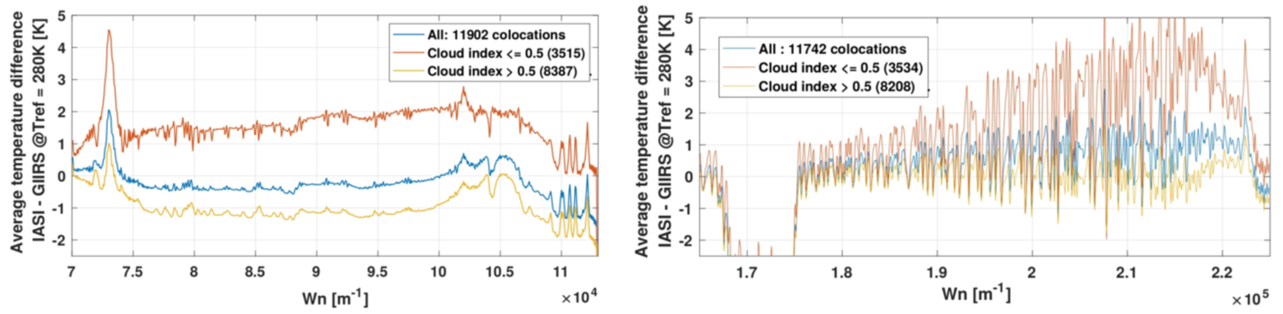
- Dependency of the radiometric calibration with the pixel position in the focal plane (including a checkerboard pattern), the scene type (see Figure 1) and the local time,
- Presence of contamination gases inside the instrument (see Figure 1),
- An anomalous residual signal in the Earth disc rim.
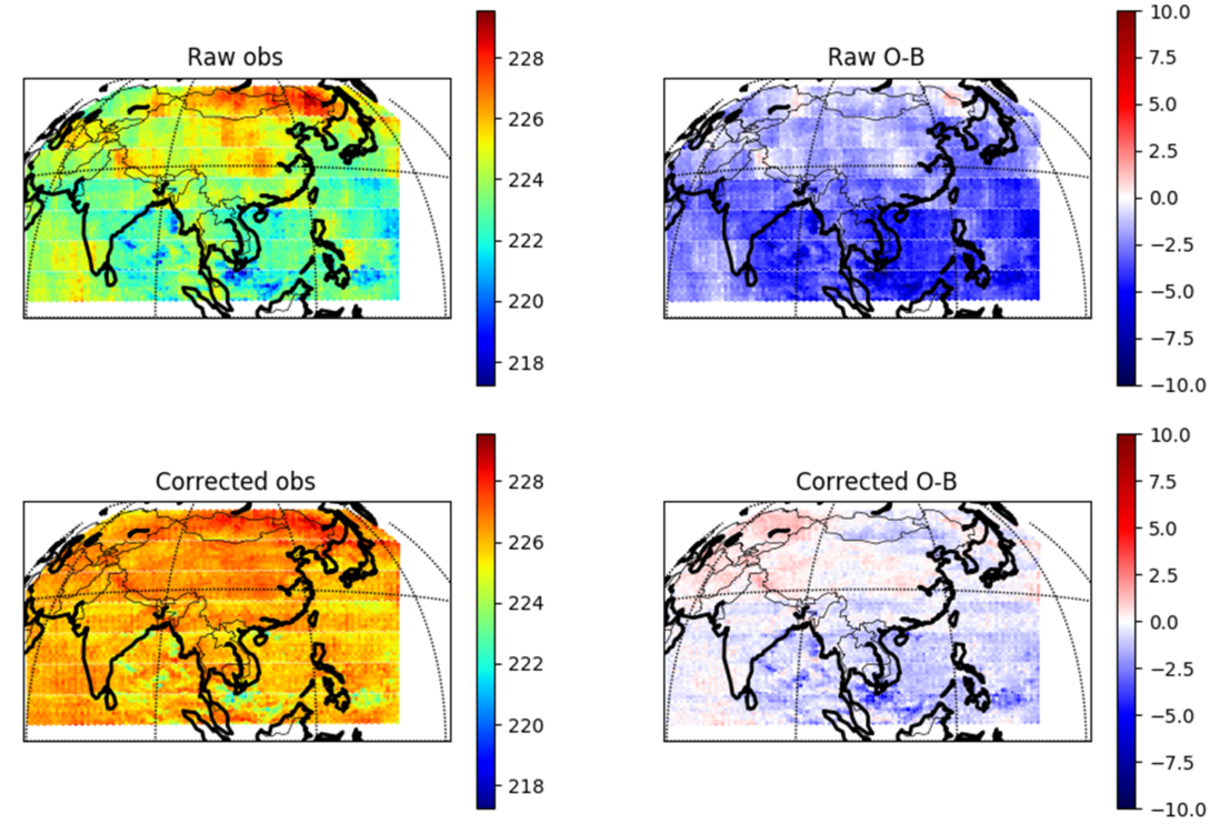
These investigations were a good opportunity to confirm the robustness and precision of EUMETSAT’s and ECMWF’s respective monitoring capabilities for hyperspectral GEO sounders. Additionally, the teams developed several strategies to adjust the GIIRS measurements compensating the radiometric dependency to the scene type (see Figure 2).
Following several performance simulations in the context of MTG-IRS, the teams concluded that the GIIRS instrument is likely subject to strong straylight (light spurious reflections and scattering inside the instrument). These findings with GIIRS lead to re-assessing possible straylight scenarios in the next generations of hyperspectral instruments and to elaborate strategies to mitigate their impact.
Finally, the ECMWF team conducted first assimilation experiments, setting up a channel and pixel selection, the observation errors, a bias correction strategy and a cloud detection (since the GIIRS data are disseminated without a cloud index). Every steps required special analyses due to the experimental nature of FY-4A/GIIRS, whose data came with irregular quality distribution. Finally, highly resolved spectral regional information at such a high spatio-temporal density from a GEO positioning was a combination never met before. Nonetheless, the ECMWF team was able to show preliminary, but very encouraging, results, with positive impacts of the GIIRS measurements on the forecasts over north Asia.