Release of new data aids understanding of rising seas
An international mission to understand a global threat

Leaders of small island states gave impassioned pleas for urgent action to halt global warming at the UN’s COP26 conference in Glasgow in November.
20 June 2023
29 November 2021
The citizens of those island states are experiencing first hand one of the catastrophic impacts of global warming, an inexorably rising sea level that puts the very existence of their homes at risk.
From today, more and better information about the Earth’s oceans and the rising sea level is available, thanks to the release of high-resolution data from the Copernicus Sentinel-6 satellite mission, after 12 months of evaluation and validation by scientists around the globe.
This is a unique satellite mission involving European and American partners working together for a more precise insight into a global climate-related challenge.
The unique status of the Copernicus Sentinel-6 mission
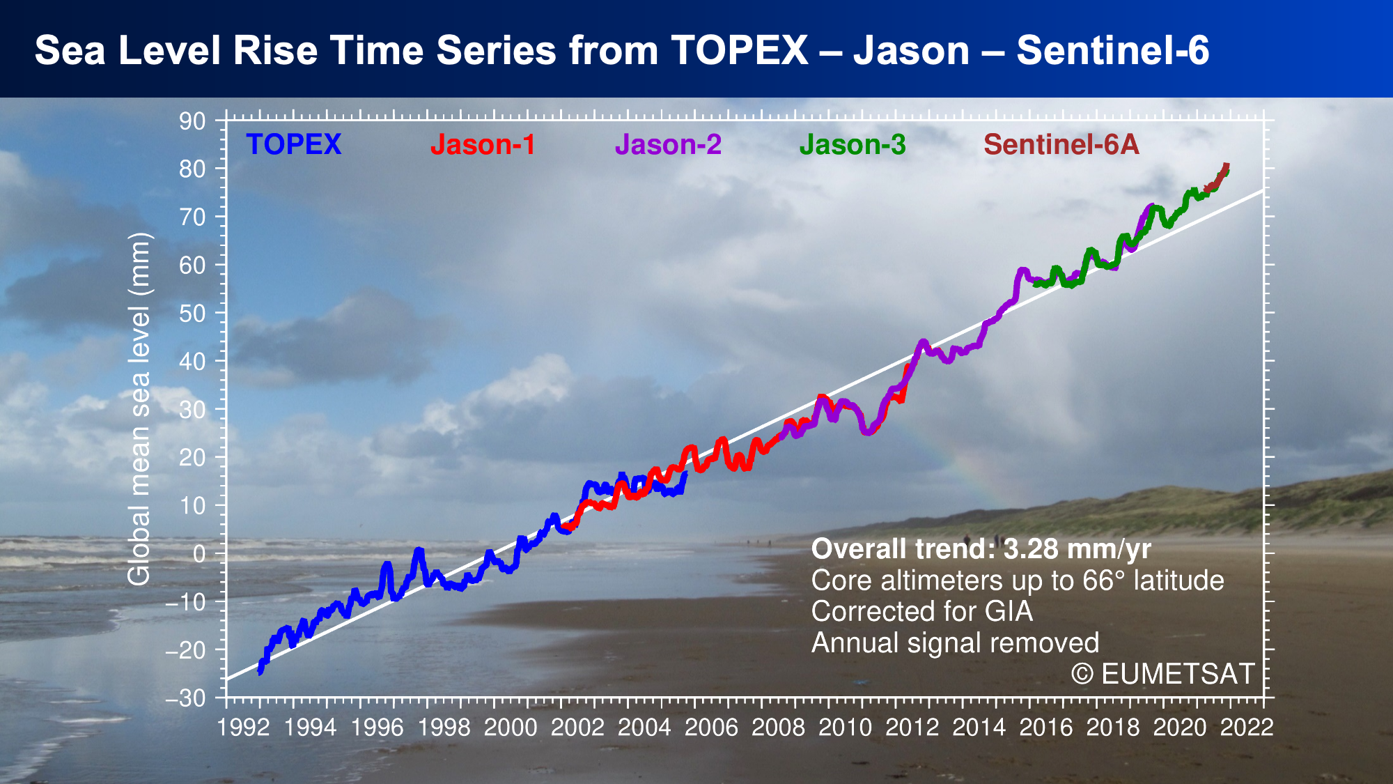
Copernicus Sentinel-6 follows directly on from a series of high-precision satellite altimetry missions that began almost 30 years ago in 1992 with TOPEX/Poseidon, a French-American initiative, and was followed without interruption by the Jason series of three satellites.
All of these missions have flown on a very particular orbit – more on that later – which is essential for determining global mean sea level.
They have been the “reference missions” for satellite ocean altimetry, meaning all other satellite altimetry missions calibrate their measurements against theirs to ensure accuracy.
The first of the Copernicus Sentinel-6 satellites, named after the late Dr Michael Freilich, a champion of this work and the former Director of NASA’s Earth Science Division, is ready to take over the role of reference satellite from Jason-3 in a few months’ time. For the time being, however, the satellite is only at the end of its “commissioning phase”.
Copernicus Sentinel-6 Michael Freilich was launched in November 2020 and has just finished its commissioning phase of intensive testing and the validation of instruments’ data.
The number of partners in the mission has grown over time, from the French Space Agency (CNES) and NASA for Topex-Poseidon, to include EUMETSAT, the US National Oceanic and Atmospheric Administration, the European Union, through the Copernicus programme, and the European Space Agency.
EUMETSAT Ocean Altimetry Programme Manager Julia Figa Saldana said Copernicus Sentinel-6 is ready to take over from Jason-3 as the reference mission.
“That’s because it has been demonstrated that the precision and accuracy of the data from Sentinel-6 is better and that the satellite and ground segment performance is reliable and robust, in other words, fully qualified for routine operations,” Figa Saldana said.
“And it comes with additional features, due to the next-generation altimeter’s capability, which opens doors to coastal and inland water applications.
“For the first time, EUMETSAT takes full responsibility for the satellite control and processing of the altimeter data.
“We are running operations as for any of our satellite programmes now, while at the same time remaining part of the important international effort that makes it possible to continue this long list of reference altimetry missions since TOPEX/Poseidon.”
What is special about Copernicus Sentinel-6?
Copernicus Sentinel-6 Michael Freilich is the first of the next-generation high-precision altimetry ocean-monitoring satellites.
Unlike the other reference missions, which provided low-resolution altimetry data, this satellite’s altimeter provides both low-resolution and high-resolution data.
The low-resolution data from Copernicus Sentinel-6 has been available since mid-2021.
Head of the Ocean and Climate Team at CLS (Collecte Localisation Satellites) Dr Fabien Lefèvre said the low-resolution-mode data are essential to provide the long-term continuity necessary for measuring changes in the climate.
These data records have continued, unbroken, for almost 30 years.
To detect changes in the climate, long series of homogenous, calibrated data are required.
The high-resolution-mode data, which provide accurate information about atmospheric corrections and sea level in coastal areas – which has not been possible before – are tremendously important for people living and working in coastal areas that are impacted by climate change, he said.
“The accuracy of Sentinel-6 will help many people improve their knowledge of the impact of climate change in waters in coastal areas,” Lefèvre said.
“We are fully confident that Sentinel-6 will also afford new improvements, mainly in coastal areas where human activities are concentrated. This is very, very important.”
Lefèvre’s team is working on tidal phenomena, including submersion during floods. This relates not just to flooding from rivers but also to submersion due to maritime flooding.
He expects the new data from Copernicus Sentinel-6 to allow for the development of new applications in this field, not just by scientists, but also for industrial use.
Lefèvre said while climatologists, meteorologists, hydrologists and the wider scientific community considered satellite altimetry data essential for information about the ocean currents, winds and waves, the benefits extended to many others.
People working at sea, such as ship captains, oil and gas rig managers, and fishermen might not directly use the data, but rely on a fusion of information from a variety of sources, of which altimetry is an important component.
Why Copernicus Sentinel-6’s orbit is so important.
Copernicus Sentinel-6 Michael Freilich flies on a non-sun-synchronous orbit.
Satellites on a sun-synchronous orbit fly over the same spot on the Earth’s surface at the same time each day.
“Monitoring large-scale oceanic signals and tides was the beginning of altimetry because the orbit of the reference mission was chosen in order to get best view of these two oceanic phenomena ever,” Lefèvre said.
“Many studies were undertaken to choose the right orbit.
“Tides are happening twice a day. If the orbit is sun-synchronous, and each time the satellite is passing over a location it is at the same time each day, it won’t see a main part of the tides.”
Lefèvre said the tracks flown by Copernicus Sentinel-6 Michael Freilich are the exact same tracks that have been flown by all reference missions for the past almost-30 years.
“That is why we are able provide information about global mean sea level rise to 1mm accuracy,” he said.
Figa Saldana also said the orbit of the reference mission is critical.
“Precise knowledge of the orbit is critical because if you don’t know with high precision where the satellite is, you don’t know where the surface of the ocean is either. Orbit is key.
She remembers the time when, still as a student, she had the opportunity to work with TOPEX/Poseidon data in the 90s.
“At that time, the big discussion was about getting the orbit right,” Figa Saldana said.
“Doing so allowed TOPEX/Poseidon to be the first altimeter mission truly adding value to operational oceanography applications.
“We are orders of magnitude advanced in orbit estimation now compared with the 90s and the orbit does not dominate the sea surface accuracy discussions any more.”
The rising sea level
While the data from Copernicus Sentinel-6 are used for a variety of very important applications – from safety at sea to predicting the track and strength of hurricanes to seasonal weather forecasts – the importance of their role in monitoring climate change cannot be overstated.
On the first day of the United Nation’s COP26 conference in Glasgow, the World Meteorological Organisation released its provisional report for the state of the global climate for 2021.
One of the report’s key findings was that the rate of sea level was twice as high between 2013 and 2021 as it had been between 1993 and 2002.
“Global mean sea level changes primarily result from ocean warming via thermal expansion of sea water and land ice melt,” the report read.
“Measured since the early 1990s by high precision altimeter satellites, the mean global mean sea level rise was 2.1mm per year between 1993 and 2002 and 4.4mm per year between 2013 and 2021.
“This was mostly due to the accelerated loss of ice mass from glaciers and ice sheets.”
The availability from today of more precise information than ever about the state of Earth’s oceans will be crucial for gaining additional insights into sea level rise, at a time its importance – and impacts – are sharply in focus.
CLS’s role in the Copernicus Sentinel-6 mission
CLS was part of the consortium developing the Sentinel-6 altimetry ground processor for EUMETSAT and provides the Copernicus Marine Environment Monitoring Service (CMEMS) data access platform, a mission entrusted by the European Commission to Mercator Ocean International.
On behalf of CNES, CLS also carries out research and development activities and generates value-added altimetry product, where it has developed unique processing chains capable of providing data to scientists, climatologists, meteorologists, oceanographers, biologists, and hydrologists worldwide to calculate the level of oceans, lakes and rivers.