50 remarkable years of cooperation
As the Coordination Group for Meteorological Satellites turns 50, we take a look back at some of the most impactful cooperation initiatives

The Coordination Group for Meteorological Satellites (CGMS) turns 50 in 2022. As experts come together in Geneva, Switzerland, to celebrate this milestone, Mikael Rattenborg, EUMETSAT’s former Director of Operations, reflects on some of the most striking stories from across the organisation’s history.
01 November 2023
15 June 2022
From setback to support network
On 21 January 1989, the National Oceanic and Atmospheric Administration’s (NOAA) geostationary meteorological satellite programme was rocked by the failure of a primary imaging instrument on its GOES-6 spacecraft.
The second satellite in the United States’ second-generation geostationary operational environmental satellites programme, GOES-6, provided full-Earth disc profiles of cloud conditions, temperature, and moisture, day and night.
But the instrument's unexpected demise left just one remaining satellite, GOES-7, to cover the entire region from west to east. In combination with delays to next-generation programmes, there was a danger that a reduction in observations might undermine vital forecasts of everything from hurricanes, to tornados, to snowstorms.
"The loss of the primary imager on GOES-6 came at a very bad time for the US meteorological services," says Mikael Rattenborg, former Head of Operations at EUMETSAT, who now works as an independent consultant.
"It meant that North America faced the prospect of not being able to fully meet its Earth observation needs, spanning the Atlantic and Pacific Oceans, and everything in between.”
The potential shortfall prompted discussions of cooperation between Europe and the US, which took place under the framework of the Coordination Group for Meteorological Satellites (CGMS), an international organisation created in 1972 to coordinate the satellite systems that support global operational meteorology.
EUMETSAT has been the permanent secretariat of the CGMS since 1995, responsible for securing the annual plenary session, following up on plenary actions, guiding the organisation during the inter-sessional periods between plenary sessions, coordinating the CGMS working groups, and general management and administration.
"The lifespans of Europe's geostationary Meteosat satellites were far exceeding expectations at the time," Rattenborg says. "This gave Europe capacity to support the US programme.
"A decision was taken under the framework of the CGMS to reposition Meteosat-3 over the Atlantic, first at 50 degrees and later 75 degrees west. This enabled the US to focus its remaining satellite further west, over the Pacific."
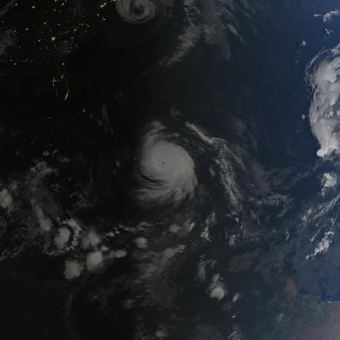
Meteosat-3 supported the prediction of hurricane Andrew, which devastated the Bahamas, southern Florida, and south-central Louisiana in August 1992. Andrew was one of the most destructive storms in living memory, but Meteosat-3's observations enabled air traffic to be rerouted and precautions taken on the ground to limit damage.
"Meteosat-3 helped to fill essential gaps in data for almost four years, from summer 1991 right up until the next-generation satellite GOES-8 became operational in 1995," says Rattenborg. "In the world of meteorological satellites, helping your neighbour is a great concept. The collaboration resulted in a more formal long-term agreement between Europe and the US to provide backup for operational meteorological satellites."

Friendships out of flames
At the turn of the millennium, Japanese meteorologists were eagerly awaiting the launch of the first of the country's next-generation geostationary satellites, Multi-functional Transport Satellite-1 (MTSAT-1). However, on 15 November 1999, a launch vehicle malfunctioned: MTSAT-1 and its high-tech instruments went up in flames.
"When the launch failed, Japan faced huge problems because its existing geostationary meteorological satellites were approaching the end of their expected lifespans," Rattenborg recalls.
With a replacement for MTSAT-1 years away, representatives from Japan and the US came together under the framework of the CGMS to devise a backup plan.
"Following its own problems in the late 1980s, the US had significantly improved its meteorological satellite capabilities, and also has a significant interest in the region through its overseas territories," Rattenborg says. "Cooperative discussions under the CGMS framework led to an agreement that the US would provide its GOES-9 satellite as a backup for existing Japanese satellites.”
GOES-9 was repositioned 155 degrees east over the equator. Meanwhile, data transmission shifted from Washington D.C. to a receiving station in Fairbanks, Alaska. It was agreed that data would then be transmitted hourly by NOAA to a meteorological satellite centre in Tokyo.
“One of the key aims of the CGMS is to ensure that satellites from different members provide data that are interchangeable,” Rattenborg says. “To do this, a lot of collaboration is needed at a very technical level.
"It’s not just about moving satellites around, but also about developing common methods of converting satellite observations into data useful for the end users. This includes national weather centres, transport, aviation, fisheries, agriculture, researchers, and many more.”
GOES-9 began its new role on 22 May 2003, just in time to capture the early stages of Typhoon Chan-Hom – a violent category four storm. While the storm did not cause the wide-scale destruction initially feared, it set the stage for the satellite's crucial two-year service to a region prone to weather-related natural disasters.
The satellite was returned to US duty upon the successful launch of MTSAT-1R in 2005.

"The success of the collaboration led to Japan and the US signing a long-term agreement aimed at guaranteeing geostationary satellite coverage over east Asia and the Pacific,” Rattenborg says.
“The cooperation strongly benefits users of satellite data in both countries and others around the world."
New foundations for forecasting
Other cooperation initiatives conceived under the CGMS framework live on today. One involves the repositioning of EUMETSAT Meteosat satellites above the Indian Ocean.
“In the late 1990s, researchers from around the world came together as part of a major project called the Indian Ocean Experiment (INDOEX)," Rattenborg says.
"Their aim was to study the impacts of human emissions over the Indian Ocean in the context of climate change. INDOEX involved mobilising a vast array of ground-, ship-, airplane-, and satellite-based instrumentation.
“Experts on the programme approached the CGMS to request satellite support to help verify measurements, monitor weather conditions, and make an array of additional atmospheric observations.
"At the time, EUMETSAT was operating three Meteosat satellites, and a proposal was made under the CGMS framework to temporarily reposition Meteosat-5 at 63 degrees east above the Indian Ocean."

The satellite provided researchers with invaluable observations spanning cloud cover, radiance data, and temperature readings. But its benefits extended well beyond the scope of the project.
"Meteosat-5 enabled meteorologists to better monitor destructive and deadly monsoon storms, the spread of volcanic ash and desert dust, and make improvements to weather forecast models," Rattenborg says.
"A proposal was subsequently made to continue observations over the region. The recent repositioning of Meteosat-9 continues a decades-long collaboration that has now seen five consecutive Meteosat satellites repositioned over the Indian Ocean.
"Data provided are particularly important for weather services on island nations and the east coast of Africa.
"EUMETSAT continues to offer this service on a best-effort basis, providing critical data on the development of monsoons and severe weather events, and boosting regional and international forecasts.”
Systematic satellite coverage
One of the most recent developments driven by CGMS-based cooperation is a joint collaboration between Europe, US, and China to expand the constellation of international polar-orbiting meteorological satellites from a two-orbit to three-orbit system. The initiative fills in temporal gaps in global observations.

“Coordinated under the CGMS framework, China took ambitious steps to redesign its FengYun-3E (FY-3E) polar orbiting satellite blueprint so that the satellite could operate in an early morning orbit," Rattenborg says.
"It was a tremendous cooperative and technical achievement. This was the first time a meteorological satellite was deployed in an early morning orbit, complementing the mid-morning and mid-afternoon systems operated by EUMETSAT and NOAA, respectively."
The proposal to place a satellite in early morning orbit evolved from discussions taking place in the context of the CGMS. The initiative was supported by a vast range of international satellite organisations, including EUMETSAT, NOAA, and the China Meteorological Administration (CMA).
"The CMA expressed a great interest in taking on this responsibility," Rattenborg says. "The framework of the CGMS provided representatives with a strong case to take to the Chinese government. Having this framework to support their ultimately positive decision was very important.
"FY-3E expands the temporal coverage of observations from polar-orbiting satellites, providing essential data for numerical weather prediction models."
Such examples underscore the importance of common technical standards and best practices that lie at the heart of the CGMS’s work, Rattenborg adds.
“By working with friends and colleagues from all over the world under the CGMS framework, we can realise the tremendous potential of meteorological satellite observations for the broader user communities and the global community in general.
“As meteorological satellite missions continue to push the physical and technical boundaries, spacecraft operators can also share burdens when there are data gaps to fill or things don't go to plan.
"Ultimately, the CGMS is helping to ensure that meteorological satellite observations of the weather, environment, and climate have the largest possible benefit to users the world over.”
Author:
Adam Gristwood