
Unprecedented wildfires devastate Siberia and spread smoke over the Arctic
Copernicus Sentinel-3 satellite, operated by EUMETSAT shows alarming extent of smoke plumes and fire impacts in Siberia and beyond

Smoke from wildfires in parts of Siberia have set undesirable new records, with experts recording plumes reaching the geographic North Pole for the first time in recorded history and that those in the Sakha region have set unprecedented records for size and intensity.
01 November 2023
17 August 2021
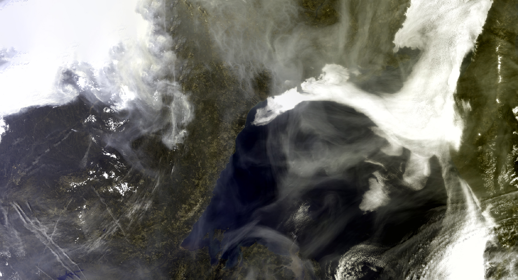
Smoke from massive wildfires in parts of Siberia have set undesirable new records in past weeks, with experts recording plumes reaching the geographic North Pole for the first time in recorded history. Other reports have shown forest fires ablaze in Siberian regions such as Sakha and Okhotsk exceeded all other fires currently burning across the world combined, and that immense Sakha wildfires have set new records for the period 1 June to 1 August. It comes after wildfires in Siberia, North America, Africa, and southern Europe contributed to the largest global total of wildfire emissions for July since comprehensive satellite records began in 2003. “Satellites are crucial for monitoring wildfires and their impact in the atmosphere and on land, says Federico Fierli an atmospheric composition expert at EUMETSAT. “This is even more important in regions where control and monitoring from ground is particularly difficult “
Satellite data and products resulting from EUMETSAT-operated missions and international partners help researchers and authorities to track wildfires, the pollution and particles they produce, and the scorched lands they create in near real time. It can help them to understand potential impacts and inform communities about potential public health risks. The long-term data are showing worrying trends, with average fire seasons in Siberia and many other parts of the world increasing in intensity and duration. By mid-August fires have burned more than 150,000 square kilometers of forest and tundra in Siberia – an area larger than the Netherlands, Belgium, and Denmark combined. Studies have pinpointed human-driven climate change as playing a key role in this change, with the average annual temperature in the Sakha region rising by around three degrees Celsius since the beginning of the 20th Century and fires in the region starting, on average, earlier and further north than they used to.
Images taken by the EUMETSAT-operated Copernicus Sentinel-3 satellite mission show brown-coloured smoke from the fires sprawling across Siberia and up towards the North Pole, where researchers have confirmed that the smoke plume from the fires reached the geographic North Pole, the first time this has been recorded since comprehensive records began in 2003. “Fires in Siberia, like in many other places across the globe, are increasing in size and intensity,” says Federico Fierli, “Although wildfires are regularly seen in Siberia at this time of year, it is becoming clear that their increasing scale is now the norm, rather than the exception – the trend is deeply concerning.”

Other measures also reveal a deeply disturbing picture: for instance, the Absorbing Aerosol Index, which indicates the presence of elevated absorbing aerosols in the Earth's atmosphere – such as soot particles in fire smoke which absorb and scatter incoming sunlight –, clearly shows the scale and extent of fires across Siberia. On 12 August these outnumbered all other fires on Earth combined. By monitoring aerosol particles suspended in the air, researchers are able to learn their global distribution and understand their long-range transport. EUMETSAT is responsible for generating and ensuring the quality of near-real time aerosol observations, as well as long-term validation and improvements, helping researchers and organisations track the intensity and emissions of wildfires the world over.

Satellites are one of the most important ways of monitoring wildfires, especially in large and remote regions such as Siberia. Images taken by satellites operated by EUMETSAT and international partners such as NASA have revealed smoke plumes stretching some 3,200 km from east to west and 4,000 km from south to north. Analyses of past records in Siberia indicate that on average fire seasons are beginning earlier, finishing later, and their intensity is increasing.

The European Copernicus Atmosphere Monitoring Service (CAMS) estimates that the emissions between 1 June and 15 August from the Sakha Republic total approximately 800 megatons of carbon dioxide equivalent, in comparison to 450 megatons for the whole of 2020. Observations cannot provide a complete view, however a system merging Earth Observation data and a state of the art model such as CAMS can provide an integrated view to estimate crucial quantities like emissions and the resulting impacts on atmospheric pollution. "The increase in the total estimated fire emissions in the Sakha region has been almost double the total from last year – which itself was a record annual total in our fire emissions dataset, going back to 2003." says Mark Parrington, a senior scientist at CAMS. “The fires have been producing vast amounts of smoke pollution throughout the whole summer, which has in some cases crossed the Arctic Ocean to reach North America. Boreal forests and peatlands are also being deeply affected, undermining carbon storage and other key services these essential habitats provide.”