

25 February 2026
23 February 2026
About
As the operational agency for the Copernicus Sentinel-3 and Sentinel-6 missions, EUMETSAT is responsible for ensuring the long-term continuity of the global sea level record. With the Sentinel-6 Next Generation (S6NG) mission on the horizon, the community faces a critical decision regarding the maintenance of the historical reference orbit used since 1992.
To evaluate this, the European Space Agency (ESA) initiated the ORBITAS study to assess the impact of potential orbital changes on the Mean Sea Level (MSL) uncertainty budget. Led by a European consortium headed by Magellium, ORBITAS assesses three distinct scenarios:
- maintaining the historical reference orbit,
- shifting to a lower orbit without tandem phases,
- eliminating the reference mission concept entirely to rely on varying orbit solutions.
This specific study, commissioned by EUMETSAT, integrates into the broader ORBITAS framework by complementing the third scenario. By analyzing data from non-reference missions, such as the EUMETSAT-operated Sentinel-3 series, Envisat and CryoSat-2, we aim to determine whether a stable, climate-quality sea level record can be constructed without relying on reference missions. Building on previous EUMETSAT research, this project provides essential insights into uncertainties in sea level trends and accelerations across various time spans, ensuring robust validation for future operational altimetry strategies and climate monitoring capabilities.
Objectives
The objectives of this study are as follows:
- Determine the SLR-SUB for non-reference altimetry missions.
- Enable the estimation of uncertainties in sea level trend and acceleration at global and regional scales, as well as across various spatial and temporal scales.
- Evaluate the SLR-SUB using three complementary approaches:
- Compare sea level trend and acceleration estimates from non-reference missions with those from established reference missions.
- Analyse the closure of the sea level budget using data from both reference and non-reference missions.
- Conduct an energy budget closure analysis incorporating data from both mission types.
Overview
In order to achieve the aforementioned objectives, the study will perform the following three tasks:
- Task 1: Provide the Sea Level Rise Stability Uncertainty Budget (SLR-SUB) of non-reference altimetry missions.
- Task 2: Assess the SLR-SUB of non-reference altimetry missions.
- Task 3: Analyse the effect of the ocean variability observability by the non-reference altimetry missions.
Task 1: Provide the Sea Level Rise Stability Uncertainty Budget (SLR-SUB) of non-reference altimetry missions (WP 1)
For a single mission or a series of missions, the SLR-SUB is an exhaustive inventory of uncertainty sources affecting trend uncertainty estimates. For each term, the underlying effect is explained (e.g. specific geophysical corrections, instrumental effects). The temporal structure of the uncertainty is described, and its magnitude is quantified. Table 1 presents the current SLR-SUB of the reference altimetry missions for the Global Mean Sea Level.
| Source of uncertainties | Uncertainty characterisation | ||
|---|---|---|---|
| Temporal structure | Standard deviation (1-σ ) | ||
| Short-term time-correlated effects due to altimeter parameters and corrections, precise orbit determination, environmental corrections, mean sea surface, oceanic variability | Short-term time-correlated effects at 1 month | u = 1.6 mm over the TP period u = 1.2 mm over the J1 period u = 1.1 mm over the J2 period u = 1.0 mm over the J3 period u = 1.1 mm over the S6A period | |
| Short-term time-correlated effects at 6 months | u = 1.2 mm over the TP period u = 1.1 mm over the J1 period u = 1.1 mm over the J2 period u = 1.0 mm over the J3 period u = 1.2 mm over the S6A period | ||
| Wet troposphere correction stability | Large-term time-correlated effects at 5 years | u = 1.1 mm | |
| Precise Orbit determination stability | Gravity field | Large-term time-correlated effects at 10 years | u = 1.1 mm before 2002 (TOPEX period) u = 0.5 mm after 2002 (Jason-1/Sentinel-6 period) |
| ITRF | Linear time-correlated effects | u = 0.1 mm yr−1 over 1993–present | |
| Inter-missions global mean sea level offset | Anti-time-correlated effects from each part of the offset. | u = 2.4 mm for TP-A/TP-B u = 0.6 mm for TP/J1 u = 0.2 mm for J1/J2 u = 0.2 mm for J2/J3 u = 0.4 mm for J3/S6A | |
| Global isostatic adjustment (GIA) | Linear time-correlated effects | u = 0.05 mm yr−1 over 1993–present | |
| Topex-A/Topex-B instrumental stability | Linear time-correlated effects | u = 0.7 mm yr−1 over the TP-A period u = 0.1 mm yr−1 over the TP-B period | |
Table 1: SLR-SUB of reference altimetry missions (update of Ablain et al., 2019; Guérou et al., 2023).
This task aims to determine the SLR-SUB for non-reference altimetry missions, building upon prior work conducted for reference missions at global mean and regional scales (Ablain et al., 2019; Guérou et al., 2023; Prandi et al., 2021, ASELSU - Assessment Sea Level Rise Stability Uncertainty project).
The study will focus on providing the SLR-SUB for the following non-reference altimetry missions spanning the altimetry era from 2002 onwards:
- ENVISAT
- CRYOSAT-2
- SENTINEL-3A and SENTINEL-3B
The SLR-SUB for non-reference missions is derived from the SLR-SUB for reference missions (see Table 1) by re-examining all uncertainty sources, in particular:
- uncertainties arising from short-term, time-correlated effects (less than 1 year), due to instrumental errors, errors in the Precise Orbit Determination (POD), or environmental corrections;
- uncertainties arising from large-term, time-correlated effects (at 5 years), due to environmental corrections;
- uncertainties arising from large-term and linear time-correlated effects, due to the precise orbit determination;
- uncertainties arising from offsets when linking sea level time series between different missions.
Task 3 will specifically address the uncertainties arising from the spatio-temporal sampling of the ocean variability, which is expected to differ between reference and non-reference missions.
Task 2: Assess the Sea Level Rise Stability Uncertainty Budget (SLR-SUB) of non-reference altimetry missions (WP 2)
This task aims to assess the SLR-SUB for non-reference missions by computing a Global Mean Sea Level data record using only non-reference missions and comparing it to independent data. By analysing these differences together with their associated uncertainties derived from the SLR-SUB, we can evaluate the non-reference SLR-SUB defined in Task 1.
This task is divided into three sub-tasks, each corresponding to a different comparison method.
Compare the mean sea level data record between non-reference and reference missions (WP 2.1)
This task aims to calculate and analyse mean sea level (MSL) trends and accelerations, together with their uncertainties derived from SLR-SUB, for both reference and non-reference altimetry missions at global and regional scales. It will then compare these trends and accelerations between the two mission types across various time spans and at specific time periods. By analysing these differences in light of their associated uncertainties derived from SLR-SUB, we can evaluate the non-reference SLR-SUB as defined in Task 1.
To achieve this, we will utilise AVISO L2P and RADS products to create a mean sea level time series for ENVISAT, CRYOSAT-2, SENTINEL-3A, and SENTINEL-3B. This analysis is designed to complement and strengthen the findings presented by Scharroo et al. (2024) at the 30 Years of Altimetry Symposium.
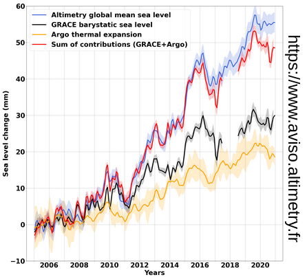
Analyse the Sea Level Budget closure with non-reference altimetry missions (WP 2.2)
This sub-task involves analysing the closure of the sea level budget using non-reference missions. In theory, the residuals of the sea level budget (Eq.1) should be null if the sea level components are consistent together:
R = △GMSLrel - △GMSLbary - △GMSLthermo | (Eq.1) |
where R is the residuals of the sea level budget, △GMSLrel the relative sea level component provided by altimetry measurements and corrected by the global isostatic adjustment effects, △GMSLbary the barystatic component provided by space gravimetry measurements and corrected by global isostatic adjustment effects, and △GMSLthermo the thermosteric sea component provided by in-situ temperature-salinity profiles (primarily the Argo network).
The residuals of the sea level budget will be computed using (Eq.1). Following the calculation of sea level budget residuals using non-reference missions, we will analyse the residuals for each non-reference mission and assess the closure across various time periods and time spans. These analyses will then be compared to those of the reference missions.
Analyse the Earth Energy Budget closure with non-reference altimetry missions (WP 2.3)
This sub-task aims to evaluate the consistency of Earth Energy Imbalance (EEI) estimates derived from two independent methodologies across various timeframes. The first approach is based on calculating the Ocean Heat Content (OHC) change using space geodetic data (altimetry and gravimetry) combined with in situ temperature and salinity profiles, in order to determine the Ocean Heat Uptake (OHU) and subsequently the EEI after computing the time derivative of the OHC. The second method relies on EEI estimates from CERES (Clouds and the Earth's Radiant Energy System) measurements.
This sub-task proposes a recalculation of OHC, OHU, and EEI using non-reference altimetry missions within the space geodetic data-based framework. Associated uncertainties will be derived using the SLR-SUB method developed by Marti et al. (2022). The Earth Energy Budget closure will then be analysed using these non-reference altimetry mission data. A comparison with the Earth Energy Budget derived from reference altimetry missions will be conducted to evaluate the impact on resulting uncertainties.
The added value of this analysis is twofold:
- Altimetry uncertainties can be assessed using the independent CERES measurements.
- By computing the time derivative of the mean sea level data record (i.e. progressing from OHC to OHU), small errors can be detected that may not be apparent when directly comparing sea level data records.
Task 3: Analyse the effect of the ocean variability observability by the non-reference altimetry missions (WP 3)
While the impact of ocean variability observability on reference altimetry missions was previously considered negligible for timescales exceeding one-year, stricter sea level stability requirements now necessitate a critical re-evaluation of these effects (Meyssignac et al., 2023). Recent assessments of the Jason-2 mission support this need, revealing that sampling limitations introduce a significant long-term drift of 0.2 mm/yr that can no longer be ignored.
This task involves using an ocean model to quantify the uncertainty in mean sea level estimates caused by the sampling characteristics of non-reference altimetry missions. A suitable ocean model will be selected and configured to provide mean sea level at appropriate spatial and temporal resolutions. The model's native mean sea level will then be compared with the model output interpolated to the 1-Hz along-track measurements of these missions. The resulting differences will be used to quantify the uncertainty introduced by altimetry sampling for time scales exceeding one year.
References:
Ablain, M., Meyssignac, B., Zawadzki, L., Jugier, R., Ribes, A., Spada, G., Benveniste, J., Cazenave, A., and Picot, N.: Uncertainty in satellite estimates of global mean sea-level changes, trend and acceleration, Earth Syst. Sci. Data, 11, 1189–1202, 2019.
Guérou, A., Meyssignac, B., Prandi, P., Ablain, M., Ribes, A., and Bignalet-Cazalet, F.: Current observed global mean sea level rise and acceleration estimated from satellite altimetry and the associated measurement uncertainty, Ocean Sci., 19, 431–451, 2023.
Marti, F., Blazquez, A., Meyssignac, B., Ablain, M., Barnoud, A., Fraudeau, R., Jugier, R., Chenal, J., Larnicol, G., Pfeffer, J., and others: Monitoring the ocean heat content change and the Earth energy imbalance from space altimetry and space gravimetry, Earth Syst. Sci. Data, 14, 229–249, 2022.
Meyssignac, B., Ablain, M., Guérou, A., Prandi, P., Barnoud, A., Blazquez, A., Fourest, S., Rousseau, V., Bonnefond, P., Cazenave, A., Chenal, J., Dibarboure, G., Donlon, C., Benveniste, J., Sylvestre-Baron, A., and Vinogradova, N.: How accurate is accurate enough for measuring sea-level rise and variability, Nat. Clim. Change, 13, 796–803, https://doi.org/10.1038/s41558-023-01735-z, 2023.
Prandi, P., Meyssignac, B., Ablain, M., Spada, G., Ribes, A., and Benveniste, J.: Local sea level trends, accelerations and uncertainties over 1993–2019, Sci. Data, 8, 1, 2021.