13 May 2026
22 June 2021
The service is applied to the Multi Angle Polarimeter (MAP) data from the Copernicus CO2M mission, to support the CO2M greenhouse gas algorithms with aerosol and surface retrieval.
The GRASP algorithm is designed to retrieve the complete set of aerosol properties globally. To achieve reliable retrieval from MAP observations even over highly reflective desert surfaces, the algorithm uses smoothness constraints for retrieval of continuous functions. For example, the smoothness constraints can be used for spectral dependencies of aerosol or surface BRDF parameters in a single-pixel approach and for spatial variability of different parameters.
Objectives
The study focuses on scientific support for the development of an operational level-2 aerosol retrieval, using the Generalized Retrieval of Atmosphere and Surface Properties (GRASP) algorithm, for the Multi-Angle Polarimeter (MAP) of the CO2 mission (CO2M). The main objectives include:
- Preparation, maintenance and evolution of the Algorithm Theoretical Baseline Document (ATBD). In this task the detailed description of the GRASP algorithm implementation and its adaptation for retrieving aerosol from CO2M-MAP measurements is provided, together with the results of quality performance tests.
- Production of Test-Data for the analysis of quality performance with respect to the product requirements. In this task realistic simulations of the CO2M MAP measurements are performed using aerosol and surface models harmonized with the Fusional-P UoL-FP CO2 retrieval algorithm. The simulations cover diverse observational situations, including scenarios with high and low pollution by different kinds of aerosols over water, over vegetated, bare soil and highly reflective snow land surfaces. These synthetic data are used for producing examples of level-2 GRASP aerosol and surface products, as well as for demonstrating and optimizing the performance of GRASP retrievals from CO2M-MAP measurements.
- Supporting EUMETSAT with functional performance results. Here the following aspects are considered: functional GRASP performance, processing cost, interface to input and output data, etc.
- Supporting planning for commissioning, Cal/Val and routine quality monitoring.
Overview
To support the CO2M greenhouse gas algorithms, aerosol and surface retrieval properties are required in the SWIR spectral range. Therefore, the GRASP algorithm for the CO2M mission makes synergistic use of CO2M MAP measurements at 6 spectral channels (410, 443, 490, 555, 670, 865 nm) and the measurements from the CO2M spectrometer at 2 SWIR channels from SWIR-1 centered at 1623.8nm (1620-1627.5 nm) and SWIR-2 centered at 2036.2 nm (2034.9-2037.5nm). The SWIR measurements and the geometry of observation and illumination are taken from CO2M spectrometer fields in the SCENE L2 product, where both MAPL1C and SCENE L2 data are provided on the spectrometer grid.
The performance of the GRASP algorithm and the effect of the observation geometry have been assessed using two orbits provided by EUMETSAT: orbit EUcent (nadir looking) and orbit EUwest (simulating a platform for which the nadir view is continuously looking at the glint spot ('pitched-orbit')). Based on the validation exercises (Figs. 1 and 2) it was shown that aerosol characterisation is more accurate for the EUcent orbit, providing more favorable geometries for the retrieval: wider scattering range shifted into the backward direction. In general, for all simulations, the same effect is observed: the wider the scattering angle, the better the retrieval. The studies also demonstrate that the use of a surface BRDF/BPDF climatology improves the retrieval result, in particular, for Single Scattering Albedo (SSA) and Angstrom Exponent (AExp) .
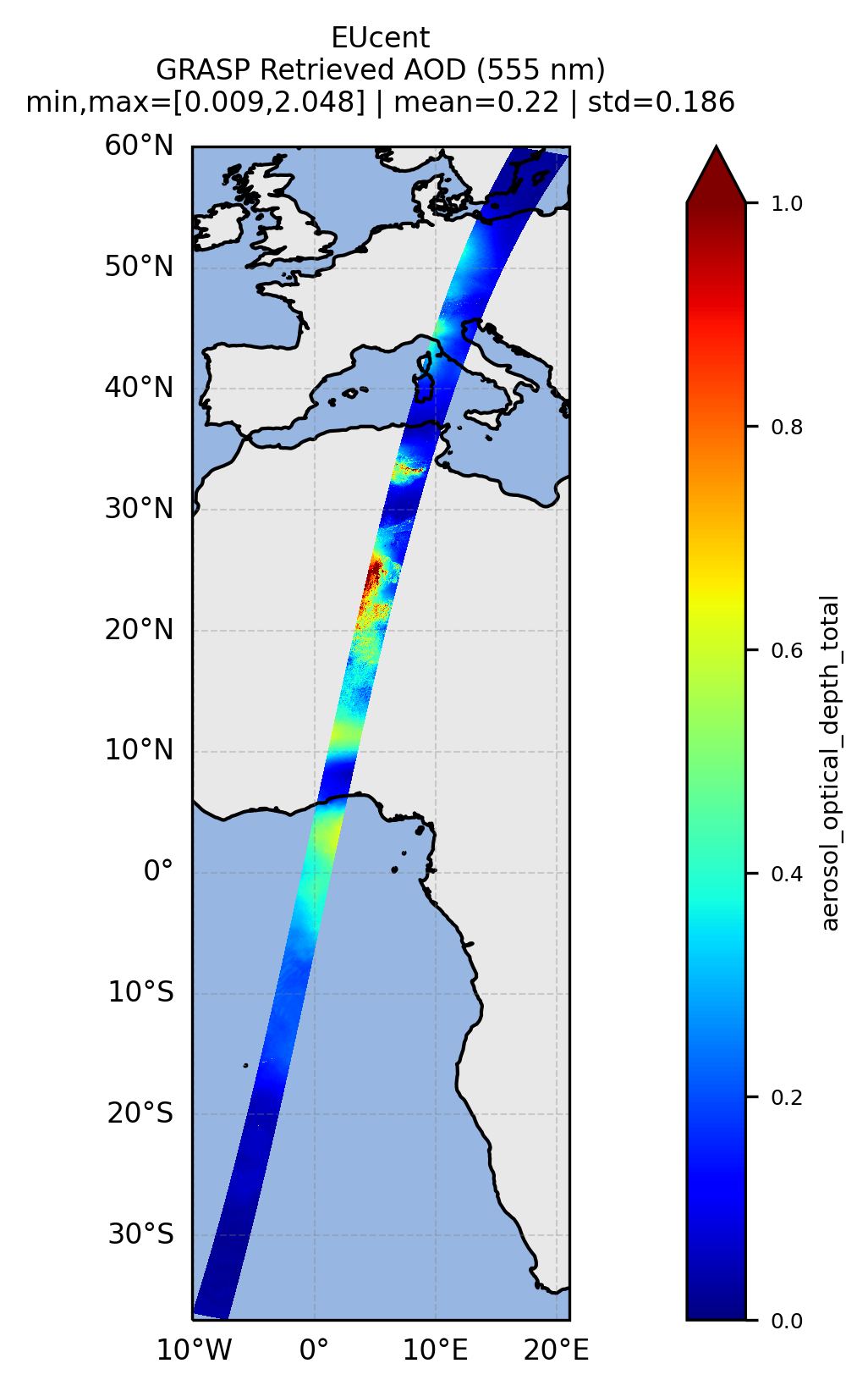
a: simulated AOD; b: retrieved AOD.
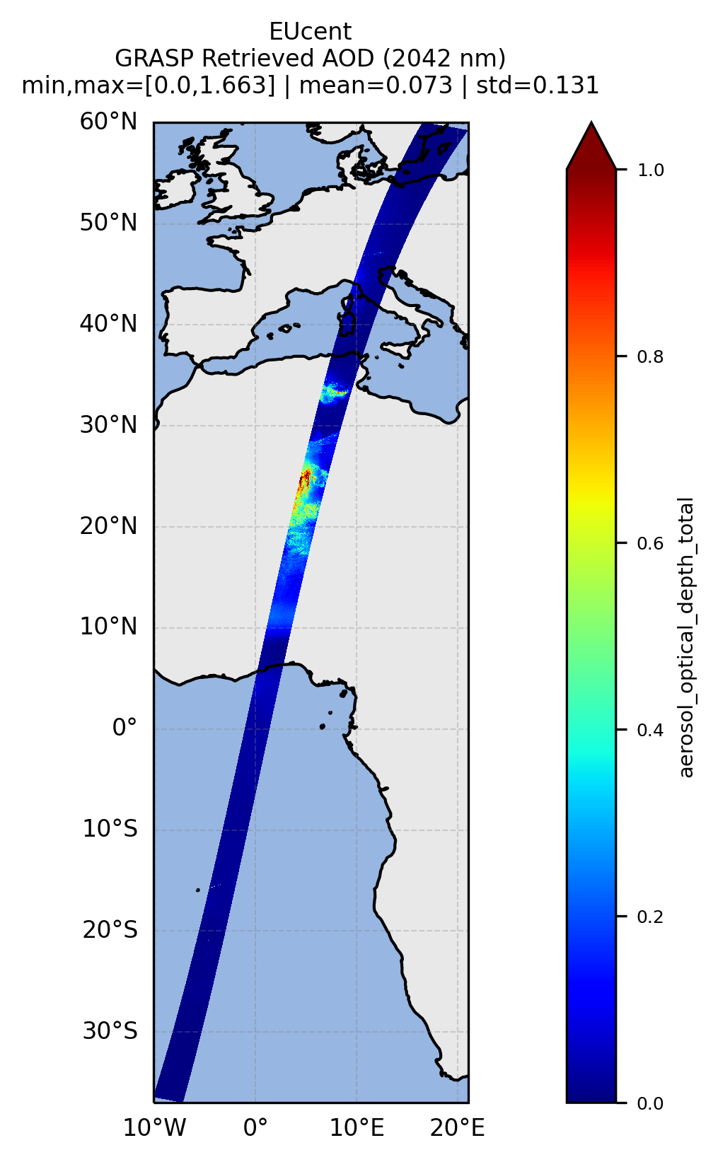
a: simulated AOD; b: retrieved AOD.
Scientific activities
The scientific support activities cover a wide range of topics to optimize the performance and resolve the challenges of aerosol and surface characterization from the CO2M MAP instrument using the GRASP algorithm. In particular, they include:
- Optimization of use of the SWIR channels and consolidation of aerosol retrieval performance aspects in the SWIR spectral range.
- Impact of pitch orbit configuration on retrieval accuracy due to retrieval over bright sun glint surfaces and reduction in number of azimuth views.
- Impact of inhomogeneous surfaces and land/water mixed scenes on the retrieval.
- Sensitivity to different surface BRDF models and BRDF parameters retrieved from different algorithms.
- Assessment of the retrieval performance over snow.
- Assessment of the impact of the polarization measurements representation (absolute values vs relative, Stokes parameters Q and U vs total polarized reflectance) on the retrieval.
- Pre- and post-processing of data and quality flagging.
An initial version of the CO2M MAP level-2 ATBD was procured under a dedicated contract. Subsequent scientific support has been organised via dedicated Work Orders within EUMETSAT’s multi-mission framework “Scientific framework for the development of AERosol Products based on GRASP” (SCAERP-G).