16 February 2023
27 April 2020
The improved water vapour retrievals will use the Copernicus Sentinel-3 OLCI's extended spectral capabilities, an improved spectroscopy of atmospheric water vapour, and an improved water surface reflectance. A detailed product validation and uncertainty characterisation will be carried out.
Objectives
The objective of COWa is the development of an improved algorithm to retrieve TCWV from Copernicus Sentinel-3 OLCI measurements, which takes advantage of all OLCI-specific defined spectral channels for water vapour at 900 nm and 940 nm, plus bands at 865, 885, 900, 940 and 1020 nm, as usable for reference. The total column (integrated) water vapour product is currently distributed as part of the standard Sentinel-3 OLCI product suite.
The product is generated over land and water surfaces. It is based on a 1D-Var algorithm approach, developed for the ESA ENVISAT/MERIS instrument and implemented in the Sentinel-3 operational ground segments (as of Q2/2020). The existing operational algorithm exhibits quality shortcomings, in the focus of this study:
- The current operational product only exploits a single absorption band, based on ENVISAT/MERIS heritage [see Lindstrot et al., 2012], but OLCI has extended spectral capabilities which are not used so far, which have been introduced to improve the TCWV retrieval. A multiple band retrieval has been developed with an implementation of an Optimal Estimation/Maximum Likelihood method.
- Over land, the Sentinel-3 standard algorithm overestimates TCWV by about 10%. This could be reduced by introducing the water vapour continuum absorption in the calculation of the retrieval look-up tables. A reduction in biases of the TCWV retrievals over land and ocean could be achieved by first validation.
- Contrary to land (where a Lambertian surface reflectance model can be used), above water bodies the algorithm must account for the strong bi-directionality of the reflectance of water surfaces, commonly described by a parametrisation of Cox and Munk (1954). However, outside of sunglint areas, in particular in the transition between medium glint and off-glint, the current retrieval is prone to errors due to ambiguities of aerosol scattering and surface reflection. An improved consideration of prior knowledge and parameterisation of the water reflectance has been introduced in the retrieval scheme.
- Over water surfaces, the TCWV is insufficiently validated and is systematically overestimated, especially in the transition zones between glint and no-glint. For a validation of the COWa ocean TCWV product, microwave and ECMWF data will be used. Plus, at coastal zones, ground-based GNSS-and AERONET-TCWV retrievals are taken.
Overview
COWa covers a thorough analysis of the shortcomings of the operational OLCI TCWV algorithm, as implemented in the current (as of Q2/2020) Sentinel-3 ground segments through product inter-comparisons and literature study. Based on these findings, the TCWV algorithm has been improved with respect to the underlying physics and mathematical implementation. The new COWa algorithm has been applied to global Sentinel-3 OLCI time-series, and validated against ground-truth observations and ECMWF water vapour analysis.
TCWV algorithm improvements
The analysis of the current OLCI TCWV products has shown a 10% wet-bias when compared to ground-truth microwave or GNSS TCVW products. This points to a shortage in the simulation of the water vapour absorption within the 940 nm ρστ-absorption band, whereby it has been identified that an appropriate description of the continuum absorption in the simulation of the transmission functions is missing [Ptashnik et al., 2011]. The improved COWa TCWV algorithm benefits from a revision of the line-by-line model [Doppler et al., 2014], which now considers the foreign- and self-continuum absorption covering the entire ρστ-H2O absorption band, while the foreign-continuum absorption is dominating and most pronounced around 0.94 µm [Mlawer et al., 2012]. All the necessary look-up tables, used in the COWa TCWV algorithm, are generated with the extended line-by-line model.
The COWa algorithm has been extended to a multiple band retrieval scheme, including both water vapour absorption channels at 900 nm and 935 nm, which rely on an updated implementation of an Optimal Estimation technique, including an uncertainty estimate of the retrieval.
The COWa algorithm has also implemented a more realistic description of the reflection of the water surface, using prior knowledge and parameterisation of the water surface reflectance in the retrieval scheme. This leads to significantly improved TCWV retrievals, especially above the transition zones from no-glint to glint areas.
Applications and validation
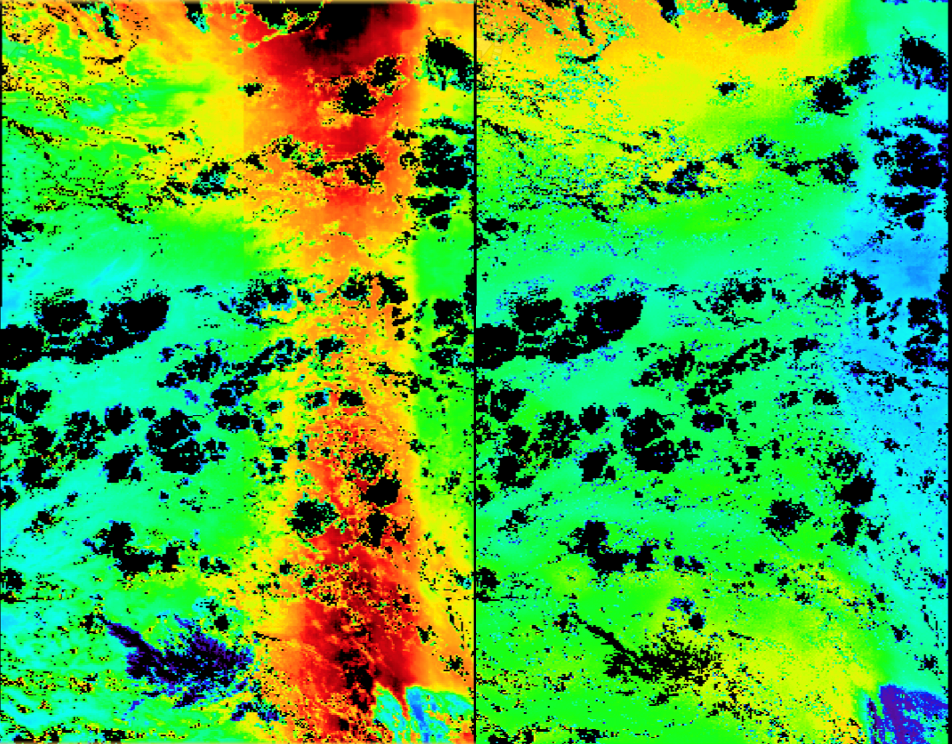
A comparison of OLCI TCWV products, derived from the standard Sentinel-3/OLCI and the new COWa algorithm, is given below. The unrealistic high TCWV values above the transition zone to higher reflectance towards the glint, estimated with the Sentinel-3/OLCI standard processor (Figure 1, left panel) disappears when the COWa algorithm is applied (Figure 1, right panel).
A first validation of the COWa TCWV product above land surfaces against ground-based GNSS-TCWV retrievals demonstrates the advantage of the new COWa algorithm, which shows a highly reduced wet-bias (Figure 2). However, further validation studies will be performed in COWa Phase II.

The new COWa TCWV algorithm has fundamental advantages to the currently used OLCI operational algorithm above land and water surfaces. The uncertainties are estimated pixel-wise and against ground-based GNSS water vapour retrievals a RMSD of 1.3kg/m2 has been found.
An initial validation of the COWa TCWV product above ocean (coastal regions) against ground-based AERONET-TCWV retrievals demonstrates the advantage of the new algorithm, which shows a significant reduced wet-bias and a much smaller RMSD (Figure 3). However, further validation studies using Sentinel-3 microwave radiometer TCWV retrieval are planned for COWa Phase II.