A better way to find tailored climate data
A new method improves upon the current one-size-fits-all approach
On the occasion of the 30th UN Climate Change Conference, COP30, we share a method developed by EUMETSAT’s Dr Rob Roebeling and his team for finding climate data tailored to specific climate applications.
“When GCOS first introduced its ECVs in 2003, these variables were mainly thought for one application – to track climate change,” said Roebeling.
“But things have changed since then. Nowadays, tracking climate change is only one of many climate applications. There are services determining extreme precipitation events, flooding warnings, changes in forests, fires, among others. Evidently, depending on the application, these services look for different types of data. For example, water management institutes in the Netherlands want to anticipate future changes – how must buffer zones be expanded or dikes be raised to cope with increasingly extreme precipitation?”
Because of these varying needs, a one-size-fits-all approach is no longer effective. As a result, GCOS tasked the international climate community with developing a broader approach covering requirements for multiple applications. In their article, Roebeling and co-authors devised a systematic method for defining the requirements to be met by products of essential climate variables, in order to provide users with an objective way of finding climate data tailored to specific climate applications. Comprising a series of mathematical equations, this method takes the relevant climate application as a starting point while taking into account the natural variability of a climate variable in space and time, as well as the specification and uncertainties in observational data.
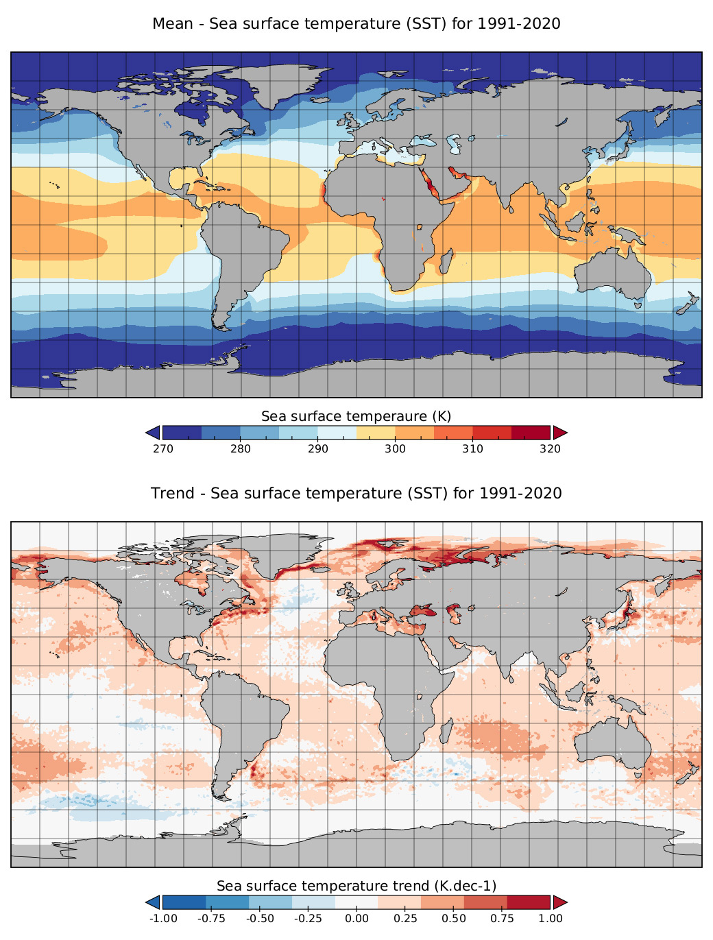
Credit: Dr Rob Roebeling, ERA-5 reanalysis data from ECMWF
A user aiming to determine the location and intensity of marine heatwaves to assess their impact regionally would be best served by a sea surface temperature dataset with high spatial and temporal sampling. For that user, it would not be as important for the dataset to be very long or extremely precise. Another user, however, whose goal is to monitor global trends in sea surface temperatures would need a long and precise dataset of sea surface temperature observations – typically 30 years or more – but would not need a dataset with very high spatial or temporal precision.
“Our goal with this paper is to help people find the dataset they need to answer their question, based on their particular climate application,” said Roebeling.
“Next, we would like to build a web-based tool that uses the mathematical equations presented in the paper. People would need to answer a few questions and enter the requirements of their climate application, after which the tool would then produce a list of datasets that meet their needs.
“Assisting climate service providers with such information is important because the impact of climate change on humans is extreme. A lot of coastal areas that are livable in now will not be livable in the future because of sea level rise. And food security is another big problem – to what extent can we feed eight billion people in a different climate?
“We need to continue to better understand climate change to try to prepare, as best we can, for what is to come.”
Read the original paper, published in the Bulletin of American Meteorological Society, here.
Author:
Sarah Puschmann