Climate
Monitoring our climate from space.

As the latest European State of the Climate Report is published, Jörg Schulz reflects on EUMETSAT’s contributions to the analysis of climate conditions and events

01 November 2023
22 April 2022
The warmest European summer on record, floods in western Europe, and megafires in the Mediterranean: the latest European State of the Climate report lays bare extreme weather events seen across Europe and the Arctic in the context of global climate change.
Published on Earth Day, 22 April 2022, the report examines climate variability in the European region during 2021. It reveals that, globally, the past seven years have been the warmest on record. This trend of exceptionally warm average surface air and sea surface temperatures continued in 2021, which was in the top seven warmest years ever recorded.
Compiled by the Copernicus Climate Change Service (C3S) and implemented by the European Centre for Medium-Range Weather Forecasts (ECMWF) on behalf of the European Commission, the report details that Europe had a year of contrasts. Spring was cooler than average, but the summer was the hottest on record, with temperatures close to 1°C above the 1991-2020 average.

The Mediterranean region was gripped by heatwaves in July and August. The continent’s highest ever temperature – 48.8°C – was provisionally recorded in Syracuse, Italy, an observation currently under assessment by the World Meteorological Organization.
In the Baltic, sea surface temperatures across large areas were recorded at more than 5°C above average.
The report also details extreme events such as devastating floods in western Europe in July, which killed more than 200 people, and summer wildfires that burned more than 800,000 hectares across southern Europe.
While many indicators show year-to-year variability, the report authors state that trends in many key climate indicators such as rising sea levels, shrinking glaciers and melting ice sheets continue unabated. Meanwhile, greenhouse gas emissions continue to rise alarmingly.

The report states that extreme weather events experienced in Europe in 2021 are made more likely by climate change, and stresses the urgent need to act now.
Jörg Schulz, leading climate scientist at EUMETSAT, reflects on some of the ways that EUMETSAT data, products, and services contribute to the report.

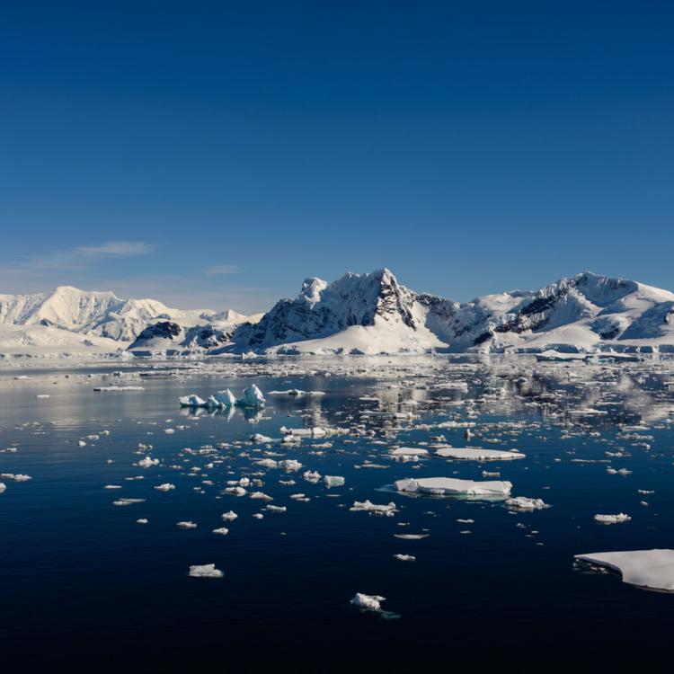
Sea ice keeps polar regions cool and plays an important role in regulating the global climate. Therefore, any problems with this natural thermostat is a cause for concern.
Satellite data help scientists to understand changes in the ice cover and its movements over time, which when pushed by winds or ocean currents can be tens of kilometres per day.
In the Arctic Ocean, figures indicate that both the extent and thickness of sea ice has fallen dramatically during the past four decades. The melting ice is strongly connected to heating seen in the region during the same time period.
Average summer sea ice concentration has decreased by 11.8 percent each decade relative to the 1981-2010 average. A smaller, yet equally pronounced, decline has also happened during winter months.

Arctic ice thickness is also reported to be plummeting by an average of around 13 percent per decade.
EUMETSAT’s Ocean and Sea Ice Satellite Application Facility (OSI SAF) uses satellite imagery to track changes and movement of global sea ice on a daily basis.
The data analysed by the OSI SAF can be used to provide some of the most direct visualisations of climate change, with graphs mapping year-on-year variations that lay bare the changes underway.
The data are also used to refine and align global and regional climate models – computer simulations that use historic and current data to simulate how the climate will likely change in the future under different scenarios.
“Satellite observations are the foundation for most of our knowledge about the evolution of the global sea ice cover,” says Schulz. “OSI SAF products provide essential evidence for understanding how climate change is playing out in polar regions.
“Together with improvements in spatial resolution, consistency across different satellite missions, and the growing bank of continuous observations, predictions for how sea ice will change in the future will further improve.
“This information will provide crucial parts of the picture needed to detail and model climate change in Europe and beyond.”

As solar radiation passes through the atmosphere, it is scattered, reflected, and absorbed by air molecules, small airborne particles, water droplets, and ice crystals. The intensity of radiation varies dramatically depending on the location, season, time of day, and atmospheric conditions.
Longer-term variations in surface solar radiation are likely a result of human activities rather than of natural origin, with aerosol pollutants very probably major drivers. In Europe, annual sunshine duration shows a clear upward trend during the past four decades.
Understanding surface solar radiation is crucial for everything from the production of crops, to planning solar energy farms, to understanding global climate change. But measuring it is hard.
“Most of the sunshine climate record has been assembled using data collected from Campbell-Stokes sunshine recorders,” says Schulz. “These are Victorian-era devices that use a glass sphere to focus the sun’s direct radiation on a paper card, scorching a track that corresponds to the duration of intense sunshine.
“For some time, researchers have also relied on more accurate ground-based sensors such as pyranometers. However, their coverage of the Earth’s surface – especially in remote areas – is relatively limited. Therefore, modern meteorological satellite observations are essential for providing a bigger picture and more detailed view of the geographic distribution of the surface solar radiation.”
Geostationary and polar orbiting satellites – such as EUMETSAT’s Meteosat series and satellites operated by other space agencies – provide essential data on aspects such as aerosols, cloudiness, precipitation, water vapour, and long-term changes in average radiation on the Earth’s surface and at the top of the atmosphere.
Meteosat measurements are used by EUMETSAT’s Satellite Application Facility on Climate Monitoring (CM SAF) to create products and maps that can be used to characterise cloud cover and estimate surface solar radiation at specific locations in Europe and beyond.
“Climate services use these products to help to build up our understanding of climate change,” Schulz says.
“Next generation satellites such as EUMETSAT’s Meteosat Third Generation and Metop Second Generation series – together with advances in techniques such as machine learning – will help us to continue and build on this vital record.”

EUMETSAT’s Meteosat geostationary satellites and Metop polar orbiting satellites provide continuous decades-long archives of space-based observations of the Earth’s atmosphere, ocean, land, and cryosphere.
Missions are supported by backup instruments in space and on the ground, as well as planned overlaps between successive generations of spacecraft. These create an invaluable resource for climate studies.
But researchers can also make substantial enhancements to the global climate record by turning to past satellite observations.
“More than six decades after the launch of the first weather satellites, the datasets collected by past missions are again proving crucial,” says Schulz.
“Historic satellite data can help us to fill in the details of the past, with comprehensive records of everything from surface temperatures, to polar ice, to essential trace gases in the atmosphere.
“Historical missions were aimed at monitoring weather, not climate. Gaps, jumps and artificial trends in data need to be corrected as much as possible to make them useful for climate change analysis.
“Luckily, we can improve the quality of past data, for instance by correcting instrument anomalies and standardising the past data collected by successive instruments in the context of the ones in operation today.
“Rescuing, restoring, and reanalysing historic measurements can make a big difference to our understanding of climate change.”
Initiatives to make past satellite and in-situ observations available for global climate analysis include grassroots efforts as well as multi-year research projects. The latter includes the European Union-funded project European Reanalysis of Global Climate Observations (ERA-CLIM and ERA-CLIM2).
“The same models that are used for weather predictions today are used in reanalysing this historic data. This provides a chance to see signals in data indicative of climate changes over past decades,” says Schulz.
The outputs from climate data reanalyses have tens of thousands of users, and contribute to almost all high-level climate documents, including the Copernicus European State of the Climate report.
“We are putting together a huge four-dimensional puzzle of weather and environment observations across multi-decadal time scales,” Schulz adds.
“The improvements in observation capabilities of EUMETSAT’s new satellites series offer new opportunities for climate monitoring, as well as ultimately providing a continuous, directly comparable record of observations that stretches over six decades.
“Combined with reanalyses of past data records, this opens up opportunities to develop more region-specific climate data reanalyses and predictions for the future.
“This will be of huge benefit to everyone: from wine growers who want to know about historical variations and future evolutions in temperature, humidity, precipitation, and soil moisture, to policymakers who want to develop ways to mitigate and adapt to climate change.”
Adam Gristwood