Unprecedented wildfires devastate Siberia and spread smoke over the Arctic
Experts have recorded Siberian smoke reaching the geographic North Pole for the first time.

As climate change drives longer heatwaves, experts say that strategies to prevent and suppress wildfires are increasingly important

20 June 2023
03 February 2022
In southern Europe, the arrival of summer is a sensory extravaganza. Sun-drenched beaches, dreamy coves, precipitous cliffs, breath-taking festivals, legendary cities, and dazzling blue seas draw millions of visitors every year.
However, there is a more ominous side to the summertime. Hot, dry weather can scorch bushland, dry out fields, and parch forests, creating the perfect conditions for wildfires.
Fires are expected in the region during the summer. But they do not usually come with consequences as severe as many parts experienced in 2021.
A series of devastating wildfires coincided with record-breaking heatwaves, first in June and then in late July to mid-August. They affected countries across the Mediterranean, including Türkiye, Greece, Italy, France, Albania, North Macedonia, and Spain, Algeria and Tunisia in north Africa, and Middle Eastern countries such as Lebanon and Israel.
The blazes ripped through farms, fields, and forests. Towering infernos reached the outskirts of ancient cities such as Athens and Olympia. They forced evacuations from the beaches of Catania, Bodrum, and Evia. Firefighters were overwhelmed. People died in their own homes.
The fires caused at least 86 deaths. It was the second worst year ever recorded for forest fires in the Mediterranean, after 2017.
The catastrophes happened against the backdrop of a major report by the Intergovernmental Panel on Climate Change (IPCC), published on 9 August 2021. It warned that worse is likely to come, with heatwaves, droughts, and floods increasingly common as a result of global heating.
António Guterres, Secretary-General of the United Nations, described the report as ‘code red for humanity’.
“Summer in southern Europe is typically hot and dry and the danger of wildfires is often extreme,” says Mark Parrington, a senior scientist at the European Union’s Copernicus Atmosphere Monitoring Service (CAMS).
“But the exceptional conditions in summer 2021 appear to have created an environment particularly conducive for intense, long-lasting wildfires. We see this strongly reflected in the active fire observations that we use in CAMS to estimate the emissions and air quality impacts of wildfires.
"Satellite data showed that fires in Türkiye in July, for example, had a heat intensity four times higher than we have seen since comprehensive records began nearly two decades ago.
“Drier and hotter conditions increase the flammability of vegetation. In some parts of the world, we are seeing that this is leading to extremely large and fast developing fires that can last for a very long time.”

In July and August, more than 200 wildfires burnt through more than 1900 km² of forests and fields. The fires were described as the worst in living memory. Satellite images taken by the Sentinel-3 Ocean and Land Colour Instrument (OLCI) showed large smoke plumes billowing out from Türkiye over the Mediterranean sea. In Bodrum on Türkiye’s Aegean coast, thousands of people were ushered onto flotillas of boats to escape the smoke and flames. At least nine people in the country were killed. Tens of thousands were evacuated from their homes.

The country’s worst heatwave in three decades coincided with infernos that blazed through regions such as Attica, Olympia, Messenia, and the island Evia – also known as Euboea. Three people were killed, hundreds injured. Images taken by the Copernicus Sentinel satellite missions revealed a disaster of nightmarish scale. More than 1250 km² of forests and bushland succumbed to flames. Ecologists say the environment will take years, if not decades, to recover.

Wildfires swept across Sicily, Sardinia, Calabria and other parts of the country. They killed people, destroyed forests and animals, and damaged world heritage sites. The fires coincided with a heatwave of extraordinary intensity, with observed temperatures above 40°C including a record-breaking observation of 48.8°C currently under assessment by the World Meteorological Organization. Firefighters were quickly overwhelmed. In Sardinia, like many other areas across southern Europe, hundreds of backup firefighters were needed – many mobilised by the European Union. Satellite images were used to identify urban areas vulnerable to the advancing flames and to evacuate those most at risk.
Isabel Trigo, head of the Earth Observation Unit at the Portuguese Institute for Sea and Atmosphere (IPMA), based in Lisbon, is well aware of the devastation that wildfires can cause.
In 2017, Portugal suffered some of the worst fire-related tragedies in its history, with major events occurring either side of what Trigo says would have previously been considered a ‘normal’ fire season.
In June 2017, an explosive combination of heat, drought, and dry storms sparked some of the worst wildfires in living memory. 66 people lost their lives, including dozens of evacuees as fires swept across roads. More than 200 were injured. Three days of national mourning followed.
Then in October, the remnants of Hurricane Ophelia passed between the Azores and the Iberian peninsula, fanning flames across a landscape left tinder-dry by a searingly hot summer. More than 50 people were killed.
“This was the largest burnt area that Portugal has ever recorded in a single day,” says Trigo, who is the scientific coordinator for the EUMETSAT Satellite Applications Facility on Land Surface Analysis (LSA-SAF). “The fires spread like they would over paper.
“There is a clear trend for fire risk to increase with climate change, not just within the fire season but the season itself is becoming wider and larger within the year.
“It becomes a vicious cycle: the absence of water means a reduction in evapotranspiration from plants. This increases the intensity of heatwaves, leading to more intensive droughts. Then all you need is an ignition for disaster to strike.”
As part of her role on the LSA-SAF, Trigo leads the development of products and services that can help authorities predict the likelihood of fires, respond to outbreaks, assess damage, and guide recovery efforts.
“One of the key ingredients is weather forecasts,” she says. “To understand the fire risk tomorrow, we need to have very good predictions for how the weather will evolve.
“To make an assessment of fire risk for a particular region, we can look at historical satellite data – in particular measurements of fire radiative power recorded from the hotspots created by fires. We then compare the weather conditions and vegetation types recorded at the time with these hotspots. It can help us to estimate the probabilities of fires growing to become very intense events under any given weather conditions.
"But we also need to account for other key aspects such as soil moisture and the accumulation of biomass. Meteorologists must therefore bring together observations from a wide range of sources to account for these variables."
Modern satellite missions such as EUMETSAT’s Meteosat geostationary satellites, Metop polar orbiting satellites, and the Copernicus Sentinel series provide diverse data for a wide range of crucial fire-related products, Trigo explains.
One example is the Fire Risk Map, which helps meteorologists understand fire risk based on probability forecasts up to five days in advance.
Another is the Normalised Difference Vegetation index, which can be used to characterise the density and drought-state of vegetation cover.
The Absorbing Aerosol Index (AAI), on the other hand, can be a good tracer for large scale smoke plumes, that can be defined using UV-wavelengths measured by instruments such as the Global Ozone Monitoring Experiment-2 and the Tropospheric Monitoring Instrument.
Fire hotspots can be identified in near-real time using the fire radiative power component of a service called Monitoring and Evaluation of Thematic Information from Space (METIS).
There are many more freely-available products aimed at all aspects of firefighting, prevention, and assessment.
“Satellite images and other data are very useful both for meteorological services and civil protection purposes," says Trigo. "They provide a synoptic view of what’s happening on the ground.
“To support firefighting, we look at the current conditions in order to predict how the situation is likely to evolve. We use these data to assess where fires might spread and identify the implications of their smoke on air quality.
“It's crucial to have an overview of fire hotspots in order to assess their intensity and establish the best way to respond.
“After the fires have subsided, we can also use satellite data to assess damage, monitor burnt areas, and over the long-term monitor vegetation recovery.”
Satellite data are also being used to understand trends in the context of land use, fire management and mitigation strategies, and the climate crisis.
Comprehensive records of fire radiative power only date back a couple of decades – when the first satellites were launched that could provide detailed observations of fire locations and intensity based on thermal anomalies on the ground.
But using these data and other historical records, meteorologists are building longer-term records that can help understand how fire risks are changing at a global level.
“Globally, there has been a gradual decline in emissions from vegetation fires over the last couple of decades as shown in GFAS and other fire emissions datasets,” says Mark Parrington. “This follows decreasing numbers of Savannah fires in the tropics related to changes in the use of fire in those regions, particularly in tropical regions of Africa and South America.
“But in many parts of the world, we are seeing another picture entirely: alarming shifts, where wildfires are starting earlier in the season, burning longer, and destroying larger areas of land than ever before.
The Copernicus Atmosphere Monitoring Service (CAMS) Global Fire Assimilation System (GFAS) brings together observations from different satellite sensors of fire radiative power from active wildfires the world over to estimate the emissions of pyrogenic pollutants in near-realtime. The estimated emissions are then used in the CAMS global and forecast systems to predict the smoke transport and potential air quality impacts up to 4-5 days ahead.

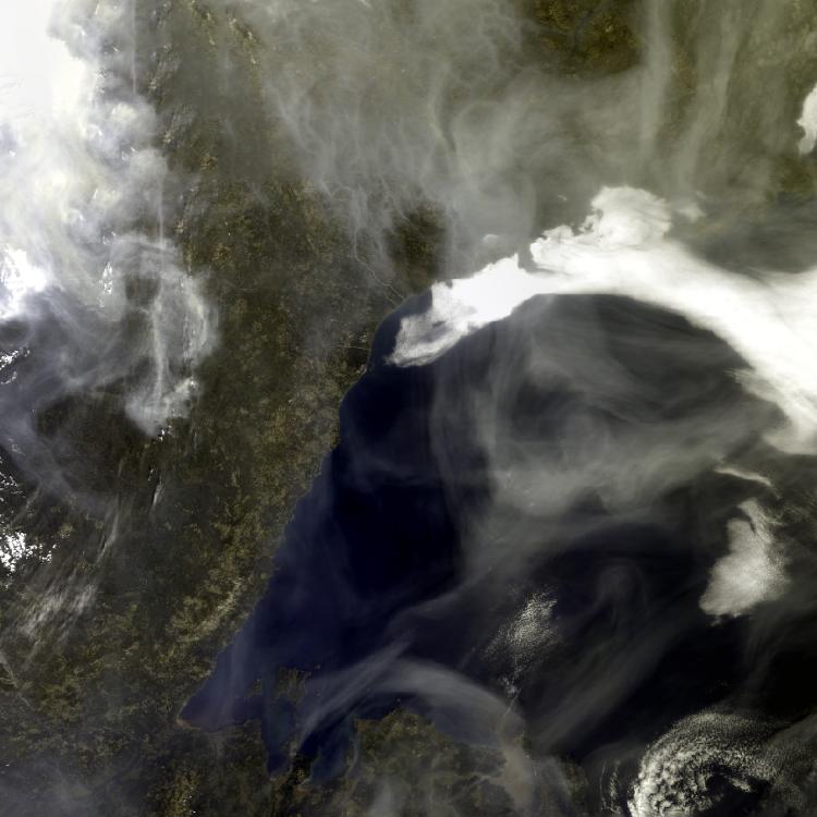
In 2021, Siberia made headlines for unwelcome reasons, with GFAS estimating extraordinary levels of emissions for a third year in a row.
Regions such as Omsk and Tyumen in the springtime, and the Sakha Republic and Chukotka in summer, were particularly affected by wildfires.
They covered Siberian cities in thick smog, sent thick smoke plumes as far as the North Pole, and destroyed essential carbon-rich peatland habitats.
“There has been a huge amplification of climate change and associated impacts in the Arctic,” says Federico Fierli, Senior Scientist and expert in atmospheric dynamics and chemistry at EUMETSAT.
"Average temperatures have increased more than almost anywhere else on the planet. Now we are getting a taste of the repercussions. In the Arctic, fires are burning longer, harder, and with greater emissions than we have seen before.
“Climate scientists had predicted this trend, but it is being realised faster than most had feared.”
In Europe, European Forest Fire Information Service data indicates that as countries have increased their firefighting capacities, fire burn areas have also decreased. But with climate change causing longer, hotter fire seasons, there has also been an increase in large, fast moving and intense fires that are much harder to extinguish.
Establishing clear patterns, however, is difficult. The European State of the Climate Report, for instance, identifies clear differences between European regions at larger and smaller scales, especially where weather and other environmental factors become critical in how the fire behaves.
But Fierli says that if trends seen in the Arctic are – as expected – mirrored in southern Europe, authorities will have to change the way they prepare for, tackle, and recover from wildfires.
“When you have a longer fire season with more intense fires, the means that the country has to fight fires may no longer be sufficient,” he explains.
“We saw in Sardinia in the summer, for instance, that while the infrastructure and aircraft needed to fight wildfires exists, it's not always enough. With the average duration, size, and timespan of fires predicted to increase, this will be particularly testing for our capacity to respond on the ground.
"We will need to improve both the compatibility of early warning forecasts and the monitoring of fires. This is also a transboundary issue, especially in terms of mobilising resources and reacting to impacts of wildfire in our atmosphere.
“The smoke and pollutants emitted from burning material are transported by the winds and can even circulate across continent as we have seen in the case of fires in California and Siberia. In addition to monitoring the location and evolution of the fires, estimating their emissions and where the smoke will end up is an essential component of this work, which ultimately has impacts on our climate.”
Next-generation satellites and related products will support this endeavour. Isabel Trigo points to EUMETSAT’s Meteosat Third Generation (MTG) geostationary satellites and Metop - Second Generation polar orbiting satellites as potentially revolutionising firefighting and recovery strategies.
“There will be some massive improvements,” she says. “For instance, the enhanced spatial resolution of geostationary satellites will enable us to massively improve models that bring together different observations to make predictions about fire outbreaks and spread.
“These variables include land cover, land use, vegetation state, vegetation humidity, and short range weather forecasts. The power of these models comes from drawing information from a wide range of sources, and the more accurate these observations are, the better the forecasts that can be made.
“Advances in the polar orbiting satellites, on the other hand, will allow us to collect close-up images as the satellites pass overhead. Polar orbiting satellites are much closer to the Earth’s surface, and their images enable us to make comprehensive assessments of burnt areas just after fires have taken place.”
Combining these diverse observations can also enable meteorologists to better identify potential fire hotspots, where fire fronts are, and to predict the spread of the fires based on different emergency response scenarios.
“Firefighters and civil authorities ask us to provide predictions for different scenarios,” Trigo says. “Our work is heading in the direction of developing models where we run simulations of the fires based on current data that can predict their evolution in a relatively short time window.
“For the firefighters this will be very, very useful because they have to make decisions in a split second. This additional information could make all the difference.”
Adam Gristwood