A forecasting revolution on its way
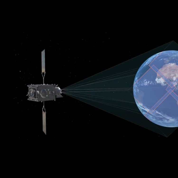
MTG-I keeps the promise of a revolution in weather forecasting.
Collaboration between countries in Northern Europe enables specialists to get the most out of data delivered by EUMETSAT’s programmes
01 November 2023
12 September 2023
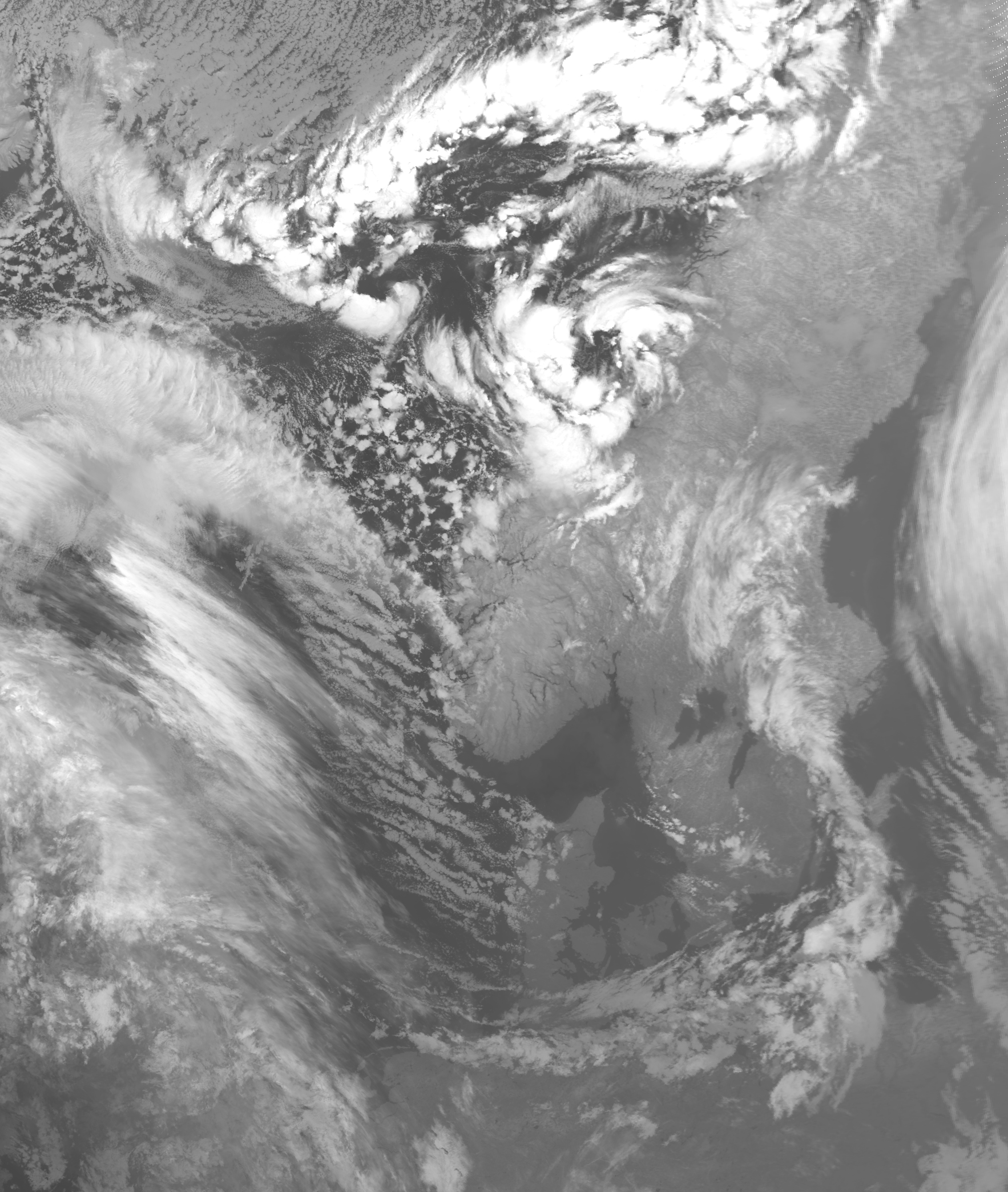
On 21 November 2022, early-season blizzards caused widespread disruption in Sweden’s south-east. Heavy snow accumulated in several regions – nearly 60 cm in just 24 hours on the Östgöta coast – and in Stockholm, road and rail services were heavily affected.
The adverse conditions prompted the Swedish Meteorological and Hydrological Institute (SMHI) to issue orange weather warnings just days after locals had been enjoying an unusually mild autumn, with thermometers topping 16°C.
“High-resolution satellite imagery provided in near-real-time allowed forecasters to track the development of the low-pressure system and deliver warnings,” says Adam Dybbroe, who works as a research lead at SMHI, with a focus on the use of remote sensing for nowcasting.
“Nowcasting involves the delivery of very short-range weather forecasts that enable authorities to alert citizens to imminent hazardous conditions. Critically, this also allows forecasters to have confidence in these predictions.”
In Sweden, the threat of hazardous snowfall comes in many guises. And one important application of nowcasting is to predict a phenomenon called sea-effect snow: discrete, narrow bands of intense snowfall that can have extreme variability, even over short distances.
“When a mass of cold, slow-moving air passes over the relatively warmer Baltic Sea, it can lead to large vertical air movements that draw up moisture from the sea and deposit it on land,” Dybbroe says.
“These narrow bands of very heavy snowfall are rather like a conveyor belt and are known locally as snökanoner (snow cannons). Snow can deposit at a rate of several centimetres per hour over several days and it is not unheard of that more than a meter of snowfall can fall in a very short space of time.”
Dybbroe says that meteorological satellite data from missions such as EUMETSAT’s Meteosat and Metop programmes are crucial for nowcasting snökanoner and predicting their local effects.
“These are typically cases where authorities need high resolution satellite and radar data,” Dybbroe says. “Transport operators, for example, rely on satellite products detailing parameters such as ice, fog, cloud phases, cloud particle sizes, temperature, and precipitation.

“These meteorological satellite data can help to reduce accidents on the roads and enable aviation and shipping to operate more safely and efficiently.”
A series of critical steps is required to receive, process, and distribute data so that they are usable across a wide range of applications in a timely manner.
“First the raw data received from the satellite need to be pre-processed, digitised, and properly geolocated,” Dybbroe explains. “Then, it requires further processing steps to create the specific end products that forecasters, authorities, climate scientists, and emergency responders rely on.
“Working collaboratively with colleagues across Northern Europe reduces the redundancy of doing the same work and creating the same products, saving time and resources. It also unites minds, for instance in developing new and better products, or in tackling challenges unique to our part of the world.”
One example of such collaboration is the United Weather Centers initiative, which unites meteorological services from Denmark, Estonia, Finland, Iceland, Ireland, Latvia, Lithuania, the Netherlands, Norway, and Sweden in the development of common numerical weather prediction models that are due to launch later this decade.
“Numerical Weather Prediction models combine information from multiple sources including in situ and remote sensing data to make the best estimate of the state of the weather at a given time and predict how it will evolve,” says Dybbroe.
“However, these models can only make use of a fraction of all remote sensing data needed for detailed descriptions of cloud and precipitation processes at short timescales. The development of smaller scale regional numerical weather prediction models means that we can get more out of the data as the amount and information content continues to grow.”
Other initiatives, such as ‘Nordmet’ and ‘Nordsat’, bring specialists from across Scandinavia and the Baltic together to prepare existing and new satellite products for data provided by next-generation missions.
“Experts from across Northern Europe have worked intensively together under the Nordsat initiative to develop and test image-generation tools and other data processing approaches for EUMETSAT’s Meteosat Third Generation (MTG) geostationary satellites,” Dybbroe explains.
“Initially the goal is to maintain operations on products well served by Meteosat Second Generation satellites – this includes aerosol properties such as dust, microphysical characteristics of clouds, and a huge range of other critical products detailing attributes from land, air, and sea.
“Meteosat spacecraft are positioned in an orbit some 36,000 km above the equator to keep pace with the Earth’s rotation, providing regular data day and night. However, as you head north, the viewing angle for geostationary satellites becomes tighter, and the surface area seen by the satellites is smaller, limiting the possible resolution of images.
“One of the great things about our cooperation is that it brings people with a wide range of expertise together in one room. This helps us to collectively identify opportunities or overcome challenges to help us to get the most out of the satellites – for instance in improving weather forecasts and storm prediction, extending climate records, and supporting crucial applications such as hydrology and oceanography.
“One area we are working on, for example, is the creation of composite analyses of cloud characteristics, such as cloud amount and height, by bringing together data provided by both geostationary and polar-orbiting satellites – something that while technically very challenging has the potential to substantially benefit forecast and climate models.
“Like with all new satellite missions, the new opportunities will only be fully realised when data become available. Our work so far means we can hit the ground running when these datasets become available for operational use.”
Specialists are hoping that the increased frequency of MTG data, which will eventually be available every 2.5 minutes over Europe, can enhance efforts to track the evolution of extreme weather events – even at very high latitudes, where the evolution of polar lows over the Arctic Ocean can be very hard to predict.
“Polart lavtrykk, or polar lows, are intense, short-lived storms that arise when cold Arctic air passes over relatively warmer seas, with the resulting convection creating towering cumulus and cumulonimbus clouds,” explains Trygve Aspenes, a senior engineer at the Norwegian Meteorological Institute.
“The storms typically feature strong winds and heavy precipitation and while they usually dissipate quickly over land, they often dump vast quantities of snow in the process, creating very dangerous weather conditions on land and at sea.
“While we can usually forecast polar lows using numerical weather predictions, their path and intensity are notoriously difficult to predict, in part because they form in remote parts of the ocean where there are very few weather stations providing data.
“Therefore, without the near-real-time satellite data provided by geostationary satellites such as the Meteosat series of spacecraft, forecasters feel kind of blind.”
MTG images will be delivered even more frequently than those from its predecessor, allowing meteorologists to track the progress of storms more effectively and compare this information with model predictions.
“With contributions from many countries around the world, we have developed software to read and handle the new data from MTG using PyTroll – an open-source Python framework for the processing of Earth Observation satellite data,” says Aspenes. “So far, with the test data and preliminary data from MTG’s Flexible Combined Imager and Lightning Imager instruments, it’s looking great.
“Emergency teams need as much information about the path of cyclones as fast as possible and MTG will provide higher quality images, more often. If a polar low develops faster or more intensely than predicted, this information can be quickly relayed to authorities and used to update weather predictions.”

Sea ice conditions over Baltic Sea, captured by the Sentinel-3 Ocean and Land Colour Instrument on the 11 February 2021. The image is processed by PyTROLL Satpy package.
EUMETSAT’s next-generation satellite data will also feed into critical environmental services. Dr Jekaterina Služenikina, Chief Specialist in the Estonian Environment Agency’s (ESTEA) Data Management and Monitoring Department, says another goal of collaboration between countries in Northern Europe is to make meteorological satellite datasets accessible to users as fast as possible.
“Countries in Northern Europe face similar challenges, including the need to provide environmental services like icing or blizzard forecasts and sea ice charting,” she says. “One effective way we tackle the challenges of producing these services is through the joint development of software and applications that enable specialists to access the right meteorological products quickly and effectively for operational work.
“One example of this is sea ice charting: in Estonia, ice maps have been an essential service since the mid-1940s. These days, the main source of data comes from meteorological satellites. However, teams need to integrate satellite radar images, products, as well as in situ and ancillary data to map conditions at levels of detail and scales required by different users – including weather forecasters, fishers, emergency responders, marine transport planners, policymakers, and scientific researchers.
“The ESTEA represents the national ice service during the winter navigation period, which includes the daily production of an ice report – a general overview of ice conditions in Estonian sea areas – and an ice map of ice cover areas, with formats specifically targeted at a range of specialists.
“This is important for several reasons: one is to grant permissions for fishers to go on the ice, which are issued by the country’s police and border guard board. Another is to support maritime authorities in delivering ice-breaking services, which enable safe winter navigation to critical port cities along the coastline and can significantly improve fuel efficiency.
“Specialists work very closely together to share knowledge, expertise, and experiences. When we have questions, we can consult with experts from other countries about how they problem-solve and innovate and share our own expertise in return to provide the best possible services to our societies.”
Služenikina says that recent preparations for MTG and EPS-SG datasets have underscored the importance of these interactions, which include regular meetings between specialists based in Scandinavian and Baltic countries.
“One of the biggest opportunities in the coming months and years lies in the usage of new satellite data with improved horizontal resolution and measurement frequency, which will enable us to process and maintain higher volumes of data and, in many cases, improve the quality of services delivered to users.
“Weather prediction requires huge amounts of expensive computing power, observations and research, so it is crucial we join forces with specialists from neighbouring countries facing similar challenges.
“Therefore, another exciting development is the European Weather Cloud, an initiative from EUMETSAT and the European Centre for Medium-Range Weather Forecasts (ECMWF), to develop a cloud computing-based infrastructure that will enhance data access and help us to store, manage and process those large datasets.
“MTG and EPS-SG missions will deliver substantial increases in spatial and temporal resolution. Developing the means to access, process and distribute data efficiently is a top priority.
“I am particularly looking forward to data from the new Lightning Imager on board MTG’s first imager satellite, which will be available for the first time over Europe and will support applications such as very short-term convective storms forecasting and flight safety.
“Another instrument I am very excited about is the Copernicus Sentinel-4 instrument onboard MTG’s sounder satellite, which will substantially increase satellite-derived air pollution measurements, improving our ability to deliver air quality forecasts and monitor greenhouse gas emissions.
“EPS-SG, on the other hand, will enable continuation and in many cases improvements of observations essential for accurate weather forecasting – including severe weather predictions, medium-range forecasts, and long-term climate monitoring.
“Climate change means that the chances of severe weather conditions are increasing - not only in winter but throughout the year. It’s critical to have this space-based information, which can help protect property and save lives.”
Adam Gristwood