Aspot Formaldehyde

First Copernicus Sentinel-5 images signal a new era in global air-quality monitoring


The Copernicus Sentinel-5 mission delivers its first images, marking a new step in global air-pollution tracking and atmospheric monitoring

Aspot Formaldehyde
Aspot Formaldehyde

The first images from the European Union’s Copernicus Sentinel-5 mission have arrived from space, showcasing a powerful new capability to track air pollution and monitor changes in Earth’s atmosphere worldwide.

Last Updated

26 November 2025

Published on

26 November 2025

Once fully operational under EUMETSAT’s responsibility and following a commissioning phase led by the European Space Agency (ESA), Sentinel-5 will deliver daily, high-quality data to support cleaner-air policies, improve pollution forecasts and help protect public health.

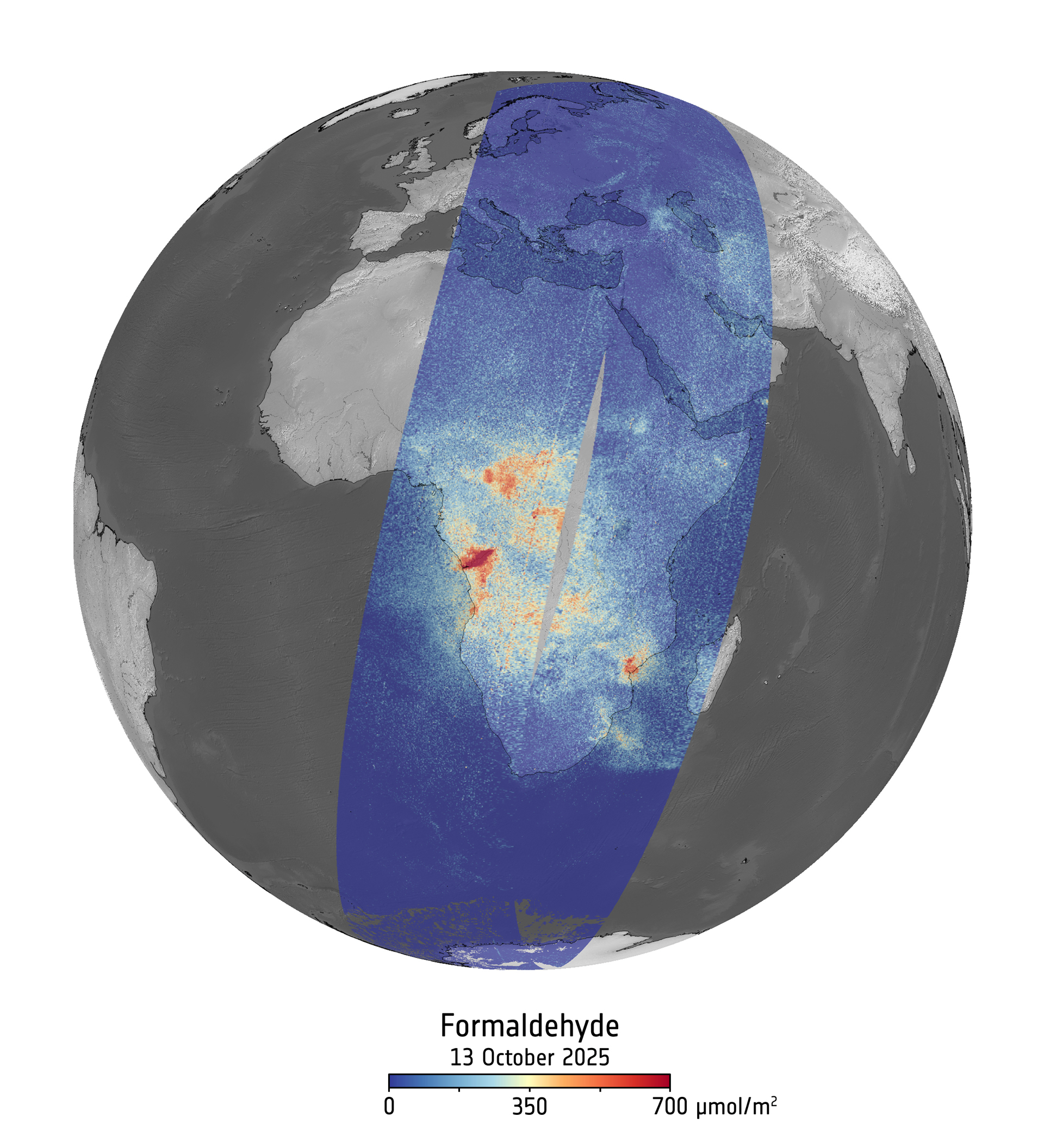
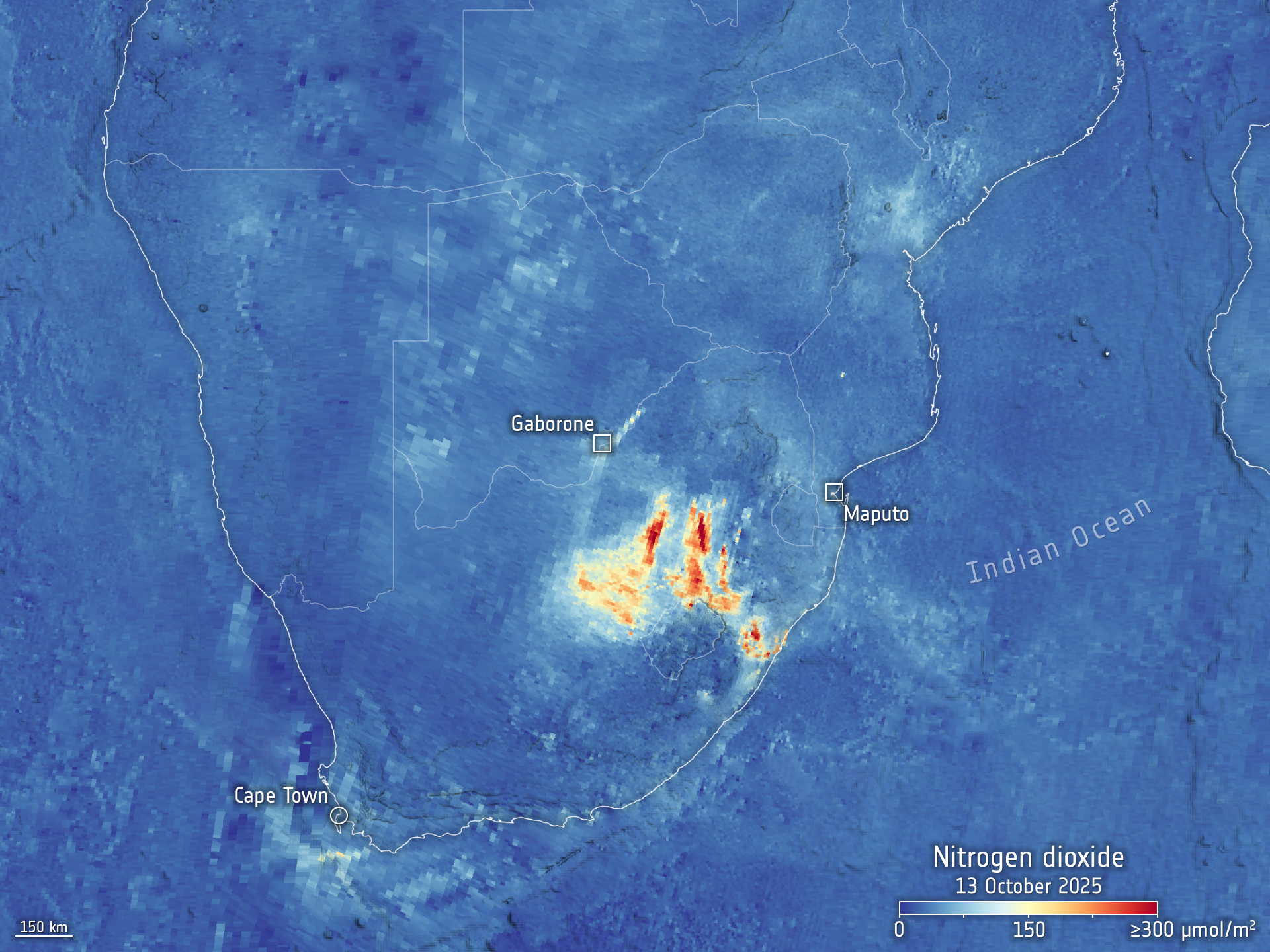
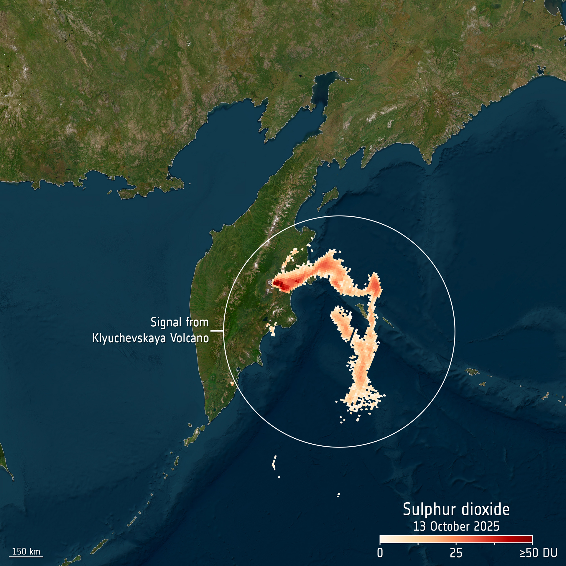
Flying aboard EUMETSAT’s Metop Second Generation A1 (Metop-SGA1) satellite, launched in August 2025, Sentinel-5 is the sixth and final instrument on Metop-SGA1 to deliver its first images, completing the satellite’s powerful suite of atmospheric monitoring tools. It is already revealing detailed maps of key pollutants such as nitrogen dioxide, sulphur dioxide, formaldehyde and ozone. These early images reveal wildfire emissions across Central and Southern Africa, elevated nitrogen dioxide levels over South Africa and sulphur dioxide from an active volcano on the Kamchatka Peninsula.

Sentinel-5’s high-resolution spectrometer system, operating from ultraviolet to shortwave infrared, works in synergy with other advanced instruments on Metop-SGA1 — including IASI-NG, METimage, and 3MI — delivering an unparalleled view of Earth’s atmosphere.

Phil Evans, Director-General of EUMETSAT, said: “Sentinel-5 is a powerful example of how Europe succeeds when we work together. Through the European Commission’s world-leading Copernicus programme, ESA has developed an exceptional instrument and EUMETSAT will now reliably operate it and ensure that its full value reaches users worldwide. Sentinel-5 will become a cornerstone of Europe’s ability to monitor air quality and support the health and well-being of citizens for years to come.”

Formaldehyde concentrations over Africa, as seen by Copernicus Sentinel-5 on 13 October 2025. Formaldehyde is a carcinogenic air pollutant. Elevated concentrations along the northwestern coast of Angola are linked to emissions from wildfires, while enhanced levels over the Central African Republic stem from a combination of fire activity and biogenic emissions. 
Image illustrative and not for operational use.
Image: Contains modified Copernicus Sentinel data (2025), processed by ESA/S&T/TriOpSys/BIRA
Nitrogen dioxide over South Africa measured by Sentinel-5. This image shows the vertical column density of nitrogen dioxide on 13 October 2025 over South Africa. High concentrations can be seen in the Highveld region, which likely come from the coal-fired power stations. Nitrogen dioxide is a major air pollutant produced primarily by human activities such as traffic, power generation, industrial processes, cooking and heating. 
Image illustrative and not for operational use.
Image: Contains modified Copernicus Sentinel data (2025), processed by ESA/S&T/TriOpSys/BIRA
Global map of ozone, captured by Sentinel-5 on 13 October 2025. Ozone plays a dual role in Earth’s atmosphere: While stratospheric ozone shields life from harmful UV radiation, ground-level ozone is a harmful air pollutant that affects human health and ecosystems.
Image illustrative and not for operational use.
Image: Contains modified Copernicus Sentinel data (2025), processed by ESA/S&T/TriOpSys/BIRA
Plume of sulphur dioxide being emitted from the Klyuchevskaya Volcano in the Kamchatka Peninsula, far eastern Russia, as seen by Copernicus Sentinel-5 on 13 October 2025. It is one of the most active volcanos in the world – having erupted more than 50 times since 1700 and is characterised by smoke continuously billowing above its summit.
Image illustrative and not for operational use.
Image: Contains modified Copernicus Sentinel data (2025), processed by ESA/S&T/TriOpSys/BIRA

About EUMETSAT

EUMETSAT, Europe’s meteorological satellite agency, monitors the weather and climate from space. Based in Darmstadt, Germany, EUMETSAT provides its 30 member states with meteorological imagery and data that are essential for keeping their communities safe and for the benefit of critical sectors of their economies.

EUMETSAT’s 30 member states are: Austria, Belgium, Bulgaria, Croatia, Czech Republic, Denmark, Estonia, Finland, France, Germany, Greece, Hungary, Iceland, Ireland, Italy, Latvia, Lithuania, Luxembourg, the Netherlands, Norway, Poland, Portugal, Romania, Slovakia, Slovenia, Spain, Sweden, Switzerland, Türkiye and the United Kingdom.


Further information about Copernicus and the EU Space Programme