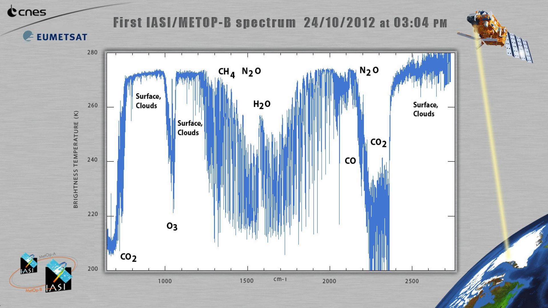
The IASI instrument on Metop-B produces first data


The Infrared Atmospheric Sounding Interferometer (IASI) instrument on EUMETSAT’s Metop-B has produced its first calibrated infrared spectrum on 24 October at 14:58 UTC
05 November 2024
30 October 2012
IASI works by measuring infrared energy emitted by the earth-atmosphere system in 8,461 individual spectral channels. Information on high-resolution vertical profiles of atmospheric temperature and humidity is extracted from IASI spectra and used as key input to Numerical Weather Prediction models, the basis of modern weather forecasts.
The IASI instrument has been developed by Centre National d’Etudes Spatiales (CNES), the French space agency, under a contract with Thales Alenia Space. CNES also monitors the instrument in orbit in order to guarantee its high level of performance.
Carole Larigauderie, IASI Mission Project Manager from CNES said " IASI on METOP-B works like clockwork. The start-up went very smoothly. This is not by chance: it is the result of the combined efforts of the CNES and EUMETSAT teams. I wish to emphasize that everything took place in a spirit of mutual trust between ESA, EUMETSAT and CNES: that counts in the success of this first stage”.
The first IASI instrument aboard Metop-A has delivered such essential improvements for Numerical Weather Prediction that some weather services consider IASI to be “the best meteorological sounder ever developed” (Météo France).
Andy Brown, Deputy Director of Foundation Science at the Met Office said: "Data from satellites plays a vital role in weather forecasting. A recent Met Office study found that satellites contributed about 65% of the total impact of observations on the performance of global weather forecasting models. IASI on Metop-A has given us the largest impact of any single satellite instrument, and we look forward to continued improvements provided by data from IASI on Metop-B."
IASI data are also used to monitor concentration of trace gases such as ozone, carbon monoxide and sulphur dioxide and in the process continue to make a huge difference to scientists’ understanding of atmospheric chemistry.
About Metop
The Metop satellites are Europe’s first operational meteorological satellites in polar orbit. They constitute the space segment of the EUMETSAT Polar System (EPS) delivering data for numerical weather prediction (NWP) – the basis of modern weather forecasting – and climate and environmental monitoring.
Flying at an altitude of 817 km, each Metop satellite carries the same sophisticated suite of instruments providing fine-scale global data, which can only be gathered in the low Earth orbit, such as vertical profiles of atmospheric temperature and moisture, wind speed and direction at the ocean surface, and some atmospheric trace gases.
Observations from Metop-A have significantly improved weather forecasts up to 10 days ahead. These forecasts are essential to protect life and limit damage to property, but they also benefit the weather-sensitive sectors of the European economy, especially energy, transportation, construction, agriculture and tourism.
The three Metop satellites, launched sequentially, will provide continuous data until 2020. The first satellite, Metop-A, was launched in 2006, and the third and final satellite, Metop-C, is scheduled for launch at the end of 2017.
ESA is responsible for the development of the three Metop satellites, fulfilling user and system requirements defined by EUMETSAT. ESA also carries out operations for the Launch and Early Orbit Phase to place the satellites in polar orbit, before handing them over to EUMETSAT for commissioning and exploitation. EUMETSAT develops all ground systems required to deliver products and services to users and to respond to their evolving needs, procures launch services and operates the full system for the benefit of users.
The EPS programme is Europe’s contribution to the Initial Joint Polar System (IJPS), with the US National Oceanic and Atmospheric Administration (NOAA).


