A forecasting revolution on its way
MTG-I keeps the promise of a revolution in weather forecasting.

Dr Vasileios Barlakas aims to maximise the potential of the EUMETSAT Polar System – Second Generation Ice Cloud Imager to support forecasts and climate monitoring

“Here my attention turned to clouds containing ice that form higher in the atmosphere, including cirriform clouds,” explains Barlakas, who is now a microwave and sub-millimetre specialist at EUMETSAT.
“Ice clouds typically begin to form at altitudes of around 5.5km above temperate regions and 6.5km above the tropics and can extend all the way up into the furthest reaches of the troposphere.
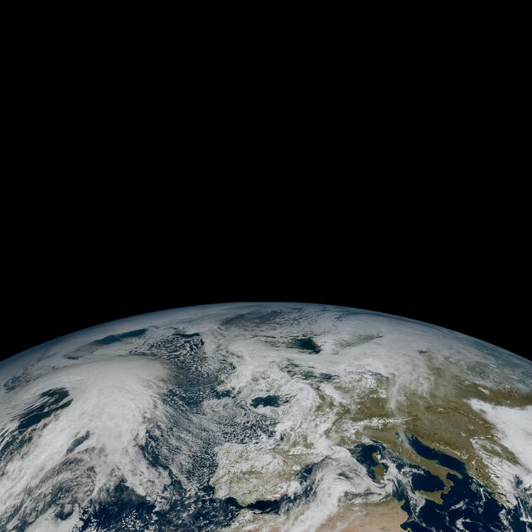
“From the ground, they can look rather enchanting, for example the cirrus clouds that spread into wispy shapes by the wind. However, ice clouds blanket up to a third of the planet at any point in time, and they therefore also play a critical role in regulating the Earth’s climate and weather patterns.”
Understanding this role is important because, depending on their characteristics and altitude, clouds may have a warming or cooling effect on the Earth.
“Some thick ice clouds, for instance, are made up of large ice crystals that can reflect incoming sunshine back to space,” Barlakas explains. “On the other hand, optically thin clouds consisting of tiny ice crystals do not reflect solar radiation yet can trap some of the heat radiating from the Earth’s surface.
“Therefore, different sized crystals within ice clouds can have markedly different effects on the global energy budget.”

Multi-spectral observations from ground-based networks and meteorological satellites are the primary means of obtaining ice cloud data at a global level for use in cloud products such as cloud amount and cloud type, which support climate monitoring and weather prediction.
“To support these products, datasets are integrated into radiative transfer models, computer simulations of how clouds absorb and scatter radiation that feed into calculations of the balance between incoming and outgoing radiation,” Barlakas explains.

“Yet despite substantial efforts, because of their high variability in size, shape and the orientation of ice crystals, ice clouds still represent some of the largest unknowns in numerical weather prediction and climate models.”
Capturing these diverse optical properties relies on observations in the visible, near infrared, infrared, and microwave channels, many of which are provided by EUMETSAT’s geostationary Meteosat and polar-orbiting Metop satellites.
“Advances in simulation software have enabled microwave data to increasingly contribute to the complete picture of ice cloud properties and structures at a global level,” Barlakas says.
“However, existing microwave channels are not able to detect smaller ice crystals, because the frequencies at which they operate are typically not sensitive enough to measure objects in the submillimetre range, which includes smaller ice crystals.”
This is set to change, however, when the Metop Second Generation (Metop-SG) series satellites are launched later this decade as part of the EPS-SG programme, thanks to instruments such as a new Ice Cloud Imager – a conically scanning radiometer that will help to fill in gaps in microwave observations and enrich global observations of ice clouds.
“What’s particularly exciting about the Ice Cloud Imager is that it will operate in both millimetre and submillimetre frequencies and will therefore be sensitive to both large and small ice crystals,” Barlakas explains. “This will enable specialists to gain a more comprehensive understanding of ice clouds and their properties.
“There will be opportunities to generate improved cloud products such as those detailing the amount of ice as measured vertically in the atmosphere – known as ice water path – and to even make predictions about the mean ice crystal diameter and the mean ice mass height.
“These products will play an important role in validating and representing ice clouds in climate and weather models.”
During his EUMETSAT fellowship, Barlakas worked on the development of software aiming to improve future cloud products by determining another major unknown in ice cloud observations: the orientation of ice crystals.

“There is a proverb that no two snowflakes are alike, and the high complexity of ice particles within clouds relates not only to their different sizes, but also their orientation,” he says.
“Nailing this down is critically important because the orientation of ice crystals results in viewing dependent optical properties, meaning that these crystals behave differently when observed from different angles.”
One project Barlakas worked on involved developing parameters that enable specialists to approximate the orientation of ice crystals and their polarisation signature within models employed by the operational forecasting system at the European Centre for Medium-Range Weather Forecasts, which calculate the distribution of radiative energy in the atmosphere,
“Radiative transfer simulations for clouds containing oriented ice crystals are very challenging and the computation is demanding,” Barlakas says.
“However, our approach has the potential to substantially decrease modelling errors and improve weather forecasts.
“Usually, a lot of attention is given to the measurement accuracy of observations, however, equally important are the methods and tools used to interpret that data.”
Since his fellowship, Barlakas has joined EUMETSAT as a consultant, supporting the development, validation, and verification of data products from microwave and sub-millimetre sensors on the EPS-SG programme.
“My fellowship provided me with the technical skills that have enabled me to go on to an incredible role working at EUMETSAT,” he says.
“I feel very lucky because during my time in Sweden I had the chance to work together with amazing scientists in a very friendly and productive environment. During my visit at ECMWF, I gained invaluable insights into how forecast systems function, and even contributed to their enhancement.
“Knowing that my work is potentially having a direct positive impact on weather predictions and climate monitoring is a wonderful feeling.
“Now everyone is looking forward to the launch of EPS-SG. There will undoubtedly be some challenging times ahead as we prepare for satellite launches, however, I’m proud to be part of a team at EUMETSAT that is ready for anything that comes our way.”
In close partnership with its member states, EUMETSAT funds a limited number of research fellowships to support young scientists in developing new uses and applications of satellite data. Through this series of articles, we showcase some of the fascinating projects Research Fellows work on, which include assimilation and analysis of satellite data to support weather prediction models; the use of satellite data for climate applications; and the development of new products and applications in areas spanning oceanography, hydrology, and atmospheric composition. EUMETSAT Research Fellows are hosted by institutions within EUMETSAT member states, who also coordinate applications to the programme in response to an annual call for proposals.