19 January 2024
16 November 2022
Infrared Atmospheric Sounding Interferometer
The IASI instrument (Infrared Atmospheric Sounding Interferometer) provides temperature and humidity profiles used to support numerical weather prediction and for making atmospheric forecasts. It provides information on the vertical structure of the atmospheric temperature and humidity in an unprecedented accuracy. Metop data account for 40% of the impact of all space-based observations in numerical weather prediction forecasts. The IASI programme is led by CNES in association with EUMETSAT. Alcatel Alenia Space is the instrument Prime Contractor.
“The Infrared Atmospheric Sounding Interferometer has been a major technological evolution compared to its predecessors and has become the cornerstone of the Earth observing system providing unprecedented and highly valuable atmospheric soundings for scientific applications in fields as varied as meteorology, climate, atmospheric chemistry, oceanography, and more.” – Dr. Fabien Carminati, Numerical Weather Prediction Satellite Application Facility Manager.
Global Ozone Monitoring Experiment–2
The Global Ozone Monitoring Experiment–2 (GOME-2) provides a detailed picture of the total atmospheric content of ozone and the vertical ozone profile in the atmosphere.
It also provides accurate information on the total column amount (the vertically integrated concentration profile of a given trace gas) of nitrogen dioxide, sulphur dioxide, water vapour, oxygen/oxygen dimmer, bromine oxide and other trace gases, as well as aerosols.
The data delivered by this instrument make a significant contribution towards climate and atmospheric research, whilst providing near real-time data for use in air quality forecasting.
The GOME-2 instrument is developed by Leonardo (formerly SELEX) in Florence, Italy, under a joint contract from EUMETSAT and ESA.
Advanced SCATterometer
ASCAT, the Advanced SCATterometer, measures wind speed and direction over the oceans, primarily for use in weather forecasting and climate research. In addition, data from ASCAT is used in the monitoring of land- and sea-ice, snow cover and soil moisture.
The ASCAT instrument is a real aperture radar, operating at C-band frequency and using vertically polarised antennas which enable it to provide good long-distance transmission and reception. ASCAT transmits pulses of microwave energy towards the sea surface and receives and records the resulting echoes for transmission to the ground station. Winds over the sea cause small-scale (centimetric) disturbances of the sea surface which modify its radar backscattering characteristics in a particular way. Data on wind speed and direction can then be derived.
The instrument was developed under EUMETSAT/ESA contract by Airbus Defence and Space (formerly EADS Astrium).
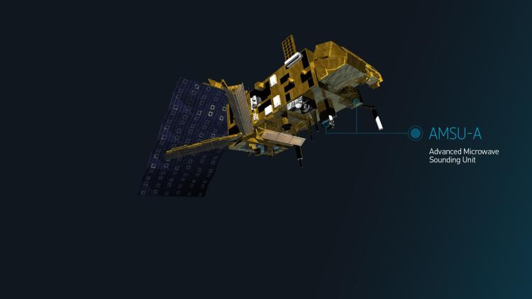
Advanced Microwave Sounding Unit-A
The Advanced Microwave Sounding Unit-A (AMSU-A) on board Metop is an American multi-channel microwave radiometer instrument provided by the US National Oceanic and Atmospheric Administration (NOAA), which is designed to measure global atmospheric temperature profiles.
It provides information on atmospheric water in all of its forms except for small ice particles, which are transparent at microwave frequencies. AMSU-A provides information even in cloudy conditions.
The data provided by AMSU-A is used in conjunction with the High-resolution Infrared Sounder (HIRS) instrument to calculate the global atmospheric temperature and humidity profiles from the Earth's surface to the upper stratosphere, at approximately 2-millibar pressure altitude (48km). The data are used to provide precipitation and surface measurements including snow cover, sea-ice concentration and soil moisture.
The instrument is manufactured by Northrop Grumman (previously Aerojet), Azusa, California under contract to NASA.
Microwave Humidity Sounder
The Microwave Humidity Sounder (MHS) is designed to collect information on various aspects of the Earth's atmosphere and surface, in particular, atmospheric ice, cloud cover and precipitation. It can also determine the temperature at the Earth's surface.
The MHS is a self-calibrating, cross-track scanning, five-channel microwave, full-power radiometer, operating in the 89 to 190gHz region. It scans the surface of the Earth three times every eight seconds, taking 90 pixels across the Earth view each scan.
The MHS data are used in numerical weather prediction models to improve the accuracy of future weather forecasts. They are also used to generate specific products, such as cloud liquid water content and total precipitable water in the atmosphere, as well as rain rates.
The MHS instrument was designed and developed by Airbus Defence and Space (formerly EADS Astrium), under contract to EUMETSAT.
Advanced Very High Resolution Radiometer
The Advanced Very High Resolution Radiometer (AVHRR) senses the Earth’s outgoing radiation in six channels (three solar channels in the visible-near infrared region and three thermal infrared channels), with a spatial resolution of 1km at nadir (the direction pointing directly below a particular location such as the downward-facing viewing geometry of an orbiting satellite).
AVHRR provides global imagery twice a day, at 1km resolution (at nadir), in the visible and infrared bands of the electromagnetic spectrum.
The AVHRR multi-purpose imaging instrument is used for global monitoring of land and sea surface temperature, cloud cover, snow and ice cover, soil moisture, and vegetation.
Due to its quick revisit times, the AVHRR has several applications such as monitoring vegetation change, active wildfires, flooding risk, and even volcanic eruptions.
This instrument is manufactured by ITT Exelis in Fort Wayne, Indiana, USA under contract to NASA.
Argos Advanced Data Collection System
The primary objective the of Argos Advanced Data Collection System (A-DCS) is the collection and dissemination of ocean data.
The Metop A-DCS contributes to the Argos worldwide location and data collection system dedicated to studying and protecting the environment. Argos provides environmental monitoring from remote stations, either fixed or mobile, fitted with an Argos transmitter. Sensors on Argos platforms collect data on atmospheric pressure, sea temperature, animal heart rates, alarm management or water level of a river. Data are transmitted to the user community through the Argos network. Flying the Argos system on board polar-orbiting satellites provides worldwide coverage.
The Argos programme is administered under a joint agreement between NOAA and the French Space Agency (CNES). The A-DCS instrument is provided under a cooperative agreement by CNES and was developed by Thales Elancourt. Data processing is performed by CLS Argos, Toulouse, France and Service Argos Inc, USA.
Search and Rescue Satellite-Aided Tracking
The main objective of the SARSAT instruments (Search and Rescue Satellite-Aided Tracking) on Metop is to relay distress signals from users in difficulty to search and rescue centres, whilst locating the source of the signals. The instruments therefore help search and rescue authorities save thousands of lives around the world. They are comprised of SAR signal Repeaters (SARR) and SAR signal Processors (SARP-3).
The SARSAT instruments on the Metop-B satellite, flying in low Earth orbit and known as LEOSAR, receive messages from emergency beacons, coordinated by the COSPAS-SARSAT programme. They are downlinked to distress terminals distributed around the globe. The messages are processed and distress alerts generated. Mission control centres receive those alerts and relay them to the appropriate rescue control centre which begins the actual search and rescue operation.
Under COSPAS-SARSAT, EUMETSAT also provides search and rescue transponders on the Meteosat Second Generation geostationary satellites.
SARR is provided by NOAA and developed by EMS Technologies of Quebec, Canada, under contract to the Canadian Department of National Defense (DND). SARP-3 is provided by CNES and developed by Thalès Systèmes Aéroportés (TSA).
Space Environmental Monitor
The Space Environmental Monitor (SEM-2) instrument is one of the non-meteorological instruments on Metop, providing information on solar activity and space weather which may affect the satellites and instruments.
SEM-2 is a spectrometer that provides measurements to determine the intensity of the Earth's radiation belts and the flux of charged particles at the satellite altitude. It is important to have information on solar terrestrial phenomena and solar wind occurrences which may impair long-range communication and high-altitude operations. These phenomena may cause damage to satellite circuits and solar panels or cause changes in drag and magnetic torque on satellites.
The Space Environment Center processes the particle counts received from Metop and monitors solar activity and the state of the Earth's near-space environment. Warnings are issued for advisory alerts, and forecasts of conditions are relayed to customers whose systems are likely to be affected.
SEM-2 is provided by NOAA and developed by Assurance Technology Corporation (ATC) under contract to NASA.
High-resolution Infrared Radiation Sounder
The High-resolution Infrared Radiation Sounder (HIRS/4) is provided by the US National Oceanic and Atmospheric Administration (NOAA). It provides calibrated vertical profiles of temperature and humidity; information on cloud cover, cloud top height, cloud top temperature and cloud phase, as well as surface albedo.
Data from HIRS/4 are used in conjunction with data from the Advanced Microwave Sounding Unit (AMSU) instruments to calculate the atmosphere's vertical temperature profile and pressure from the Earth's surface to an altitude of about 40km.
HIRS data can also to be used to determine ocean surface temperatures, total atmospheric ozone levels, precipitable water, cloud height and coverage and surface radiance (albedo).
HIRS/4 scans the Earth's surface in 20 spectral bands: one visible channel, seven shortwave infrared channels, and 12 longwave infrared channels. It provides a nominal spatial resolution at nadir (Earth facing) of approximately 20km.
HIRS/4 is manufactured by ITT Exelis in Fort Wayne, Indiana, USA under contract to NASA.
Global Navigation Satellite System Receiver for Atmospheric Sounding
GRAS (Global Navigation Satellite System Receiver for Atmospheric Sounding) is a European GNSS (Global Navigation Satellite System) receiver that operates as an atmospheric sounder. It provides unprecedented observations of atmospheric temperature and humidity that are assimilated into numerical weather prediction models to improve weather forecasting and support climate change monitoring.
GRAS uses radio occultation to measure vertical profiles of atmospheric temperature and humidity.
The GRAS instrument was developed by the instrument prime contractor RUAG Space AB in Sweden, supported by Austrian Aerospace, Sener and GMV under contract to EUMETSAT/ESA.