06 March 2026
26 May 2023
0 degree service
Providing high rate SEVIRI image data in near real time
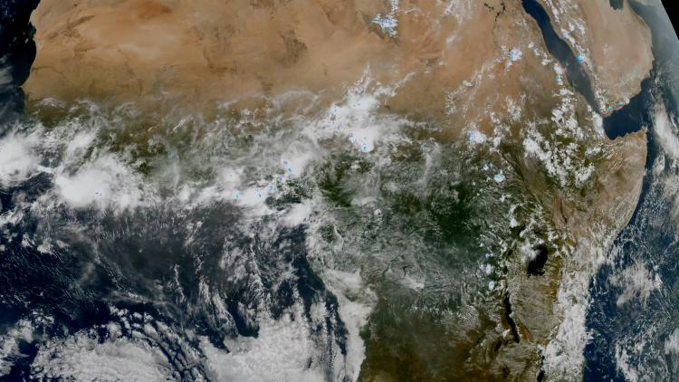
The 0 degree service is the main mission of Meteosat Second Generation (MSG), providing high rate SEVIRI image data in 12 spectral bands in near real time. The nominal coverage of the prime MSG service — the geostationary service from the MSG satellite located at 0 degrees longitude — includes the whole of Europe, the Atlantic Ocean, all of Africa and locations where the elevation to the satellite is greater than or equal to 10°. This service is currently provided by the Meteosat-10 satellite.
The SEVIRI instrument allows for a complete image scan (full Earth scan) once every 15-minute period. Each 15-minute period, or repeat cycle, consists of eight segments of image data, with the exception of the high resolution visible (HRV) channel, which has 24 segments. Each segment has 464 lines of image data.
The data are accompanied by the appropriate ancillary information that allows the data user to calculate the geographical position and radiance of any pixel. Before distribution to users of the data, the data are compressed using lossless compression.

A repeat cycle prologue file precedes the delivery of the image segments and a repeat cycle epilogue file follows after the delivery of the segments and contains final quality information for the image. The image segments are numbered and a fixed relationship between the image segment number and the line offset is established. The image segment numbering direction follows the radiometer scan direction.
As well as the high rate SEVIRI product, meteorological products are also generated and disseminated to the user community in near real-time.
Access to SEVIRI near real-time and offline data and products typically involves an initial registration process. For further information, please visit our Data Registration page, or register on the Earth Observation Portal.
Indian Ocean Data Coverage
Satellite data from over the Indian Ocean
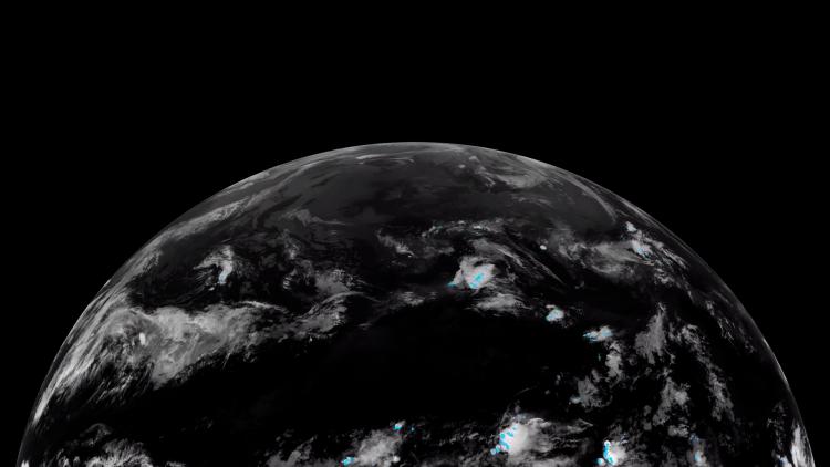
The operational Indian Ocean Data Coverage (IODC) service is delivered by the Meteosat-9 satellite from its position at 45.5°E. It was moved to this position from 3.5°E in a 79-day journey in 2022. The satellite provides image data in twelve spectral channels every 15 minutes.
The satellite is crucial for monitoring severe weather events which impact the people on Indian Ocean islands and in eastern Africa, and is also important for improved weather forecasting in Central and Eastern Europe and Central Asia.
EUMETSAT provides the Indian Ocean Data Coverage service on a best-effort basis, as its contribution to an international initiative to provide meteorological satellite coverage from the geostationary orbit over the Indian Ocean region. The service is critical for monitoring severe weather events, such as cyclones, which dangerously affect the livelihoods of Indian Ocean populations and the security of people on the African east coast.

Maritime transport, aviation, fisheries and agriculture, tourism and public weather services on and around the Indian Ocean, including the overseas territories of EUMETSAT member states, rely on the satellite’s data. The European Union and the Indian Ocean Commission facilitate access to and use of Meteosat data in the island states in support of disaster resilience and climate change adaptation.
In addition to providing meteorological imagery, the satellite provides a data collection and re-transmission service, similar to the 0 degree service. The data collection system is an important element of the Indian Ocean Tsunami Warning System, relaying measurements of sea-bed pressure variations transmitted by some 50 moored buoys, in real time, to tsunami warning centres.
Rapid scanning service
Vital service for nowcasting high-impact weather events
The rapid scanning service (RSS) scans the northern third of the Meteosat disc every five minutes.
The RSS, provided by the Meteosat-11 satellite, delivers rapid scan high rate SEVIRI image data, as well as a selection of advanced meteorological products from a position at 9.5 °E.
In addition to the full disc scan carried out by the SEVIRI instrument on board the MSG satellites every 15 minutes, rapid scanning images one third of the earth disc, covering Europe and the adjacent seas, every five minutes. Scanning a smaller area means that RSS scans can be carried out more frequently than those of the full earth disc.
This service supports the nowcasting of rapidly developing severe weather events such as thunderstorms.
As well as the high rate SEVIRI product, meteorological products are also generated and disseminated to the user community in near real time. For a comprehensive list, consult the Product Navigator.
The data dissemination for RSS imagery is identical to normal dissemination. Image segments are based on 464 lines, which are compatible with the full disc level 1.5 data scans.
For further information, please visit our Data Registration page.