
Observing wildfire smoke plumes from space
Recent wildfires in Chile had a devastating impact on the country, its people and the environment.

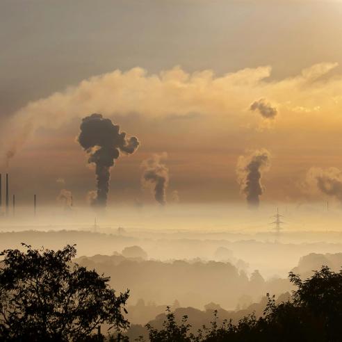
At least 11 people were killed and thousands were forced from their homes, the town of Santa Olga was destroyed and more than 160,000 hectares of forest was razed.
19 May 2022
16 February 2017
The smoke plume generated by the fires stretched more than 2,000km out over the Pacific Ocean – about the same distance as from Amsterdam to Moscow. Scientists are using satellite imagery to learn more about smoke plumes and this work has potential benefits for human health, society and economies, as well as our understanding of the climate.
How the images are made
The Satellite Application Facility on Ozone and Atmospheric Chemistry Monitoring (O3M SAF), is one of eight EUMETSAT SAFs providing operational data and software products to a dedicated user community and application area. Maurits Kooreman, of the Royal Netherlands Meteorological Institute (KNMI) and Junior Scientist working on the project for the SAF, produced the images (right) of the smoke plume from the fires in Chile. He used imagery from the Global Ozone Monitoring Experiment (GOME-2) instruments on EUMETSAT’s Metop-A and –B satellites, overlaid on imagery from the MODIS imager onboard NASA’s Terra satellite.
The O3M SAF GOME-2 product shown is called the Absorbing Aerosol Index (AAI). “As fires produce soot, as well as water, the plumes consist of a mix of the two,” Kooreman explains. “Possibly, the smoke particles in the plume are acting as condensation nuclei for the water vapour to condense on, producing a mix of soot and water droplets. “The colourful overlay in Figure 1 shows the AAI, distinguishing the soot particles from the water droplet cloud. The red values indicate an AAI of more than 3, where a value of 2 is already considered to indicate significant aerosol (fine particles in the air) presence.” Kooreman said the O3M SAF has been studying the smoke plume from the first day it was visible on satellite imagery – 20 January – and monitoring its progress and development in terms of the AAI.


“It shows very well that fires cause smoke and water clouds and, in this case, we can see how the smoke and clouds are really mixed together. We use the AAI to distinguish regions where there is smoke and where there are clouds.”
Who needs this information?
Dr Piet Stammes, Senior Scientist at KNMI and working in the O3M SAF as well, said the imagery demonstrates the meteorological processes taking place as a result of a very dramatic, deadly and environmentally damaging wildfire. “In principle, this information can be used by anyone who wants it but it is particularly important for the aviation community, which needs to know where the smoke is going,” Stammes said. “The information is also used by the climate research community because this smoke is causing the absorption of solar radiation. Climate researchers want to establish the amount of radiation from the Sun that is absorbed by the smoke. “So the information is used both for nowcasting a hazard and the climate research community.”
O3M SAF to become the Atmospheric Composition Monitoring SAF
From 1 March 2017, the O3M SAF will change its name to the Satellite Application Facility on Atmospheric Composition Monitoring (AC SAF). The name change will better reflect the type of work the SAF carries out, Dr Stammes said. “The change illustrates a new phase and that our products are not only for the ozone community but also for the air quality and atmospheric composition community,” he said. More information on the AC SAF’s activities and access to its data portfolio can be found at http://ac-saf.eumetsat.int.
Health, land use and climate – why we monitor smoke from space
One of EUMETSAT’s key objectives is to monitor the atmospheric composition, not just smoke from fires but also more generally in terms of pollution, because of the potential, immediate health impacts and the long-term, global effect on the climate.
EUMETSAT Atmospheric Composition Calibration and Instrument Team Leader Dr Rüdiger Lang said if the fires were in the Mediterranean, rather than Chile, and the smoke plume was drifting over heavily populated areas, rather than over the ocean, there would be real implications for human health, not only from the fires themselves but also from the smoke. The Copernicus Atmosphere Monitoring Service is using information like the AAI and other data from EUMETSAT to help model the behaviour of smoke plumes and pollution, so that how they travel and how they evolve can be forecast, like rain can be forecast, for example. Lang points out that fires are not necessarily bad for vegetation – they can be part of a natural cycle – but more frequent fires, hotter temperatures and more droughts can have a lasting impact on vegetation and land use.
Instruments used to monitor smoke plumes
Satellite instruments are used to measure different aspects of fires and smoke plumes: the particles, as discussed above; the chemical aspect, as fires create significant amounts of carbon monoxide; and fire radiative power. Instruments onboard EUMETSAT’s low-earth-orbiting Metop-A and –B satellites and geostationary Meteosat satellites currently measure these aspects and the capacity to do so will grow with the new and improved instruments to be carried on the next generation of these satellites, which are due to be launched within the next five years.
The aerosols created by biomass burning are released into the lower atmosphere, where they have a warming effect by absorbing and storing energy. In this case, climate change can be both a precondition for, and a result of, changes in biomass burning frequency.
Feature image: West Fork Complex wildfire / Credit: NASA