
Forecasting fires
From Monchique to Mozambique and beyond.


Is it possible to predict where a wildfire is likely to start? Or to say how ferociously it will burn before it has even ignited?
Can satellite observations help?
19 May 2022
22 August 2018
In a year of unprecedented fires in the Northern Hemisphere, from California in the US to the Arctic Circle in Sweden, scientists in Portugal have made exciting progress in doing just that - with implications for responding better to this recurring threat. (Image (top) shows fire at Estreito da Calheta, Madeira, Portugal, in August, 2016.)
Monchique, Portugal
In early August, wildfire in the Monchique region a of southern Portugal injured 45 people, caused more than €10 million in damage to property, forced the evacuation of about 2,000 residents and required the efforts of 1,450 firefighters to contain.
Three months earlier, in May, Professor Carlos DaCamara of the Faculty of Sciences at the University of Lisbon was part of a team led by Professor José M. C. Pereira of the university’s Institute of Agronomy which released a map of Portuguese municipalities illustrating their risk of a major blaze during this year’s fire season.

Professor Carlos DaCamara
(A newspaper article, in Portuguese, showing the list of Portuguese municipalities with risk of major fire, can be seen here.)
However, according to a statistical model developed by Professor DaCamara’s research group, a severe fire season was not expected to occur, given the mild temperatures and rainfall observed during spring and early summer.
(An interview with Professor DaCamara, in Portuguese, can be seen here.)
Although the project found the chance of experiencing fires in Portugal on the same scale as the deadly blazes of last year was lower, it identified the areas at risk.
The region of highest probability of a major fire? Monchique.
Here’s the back story.


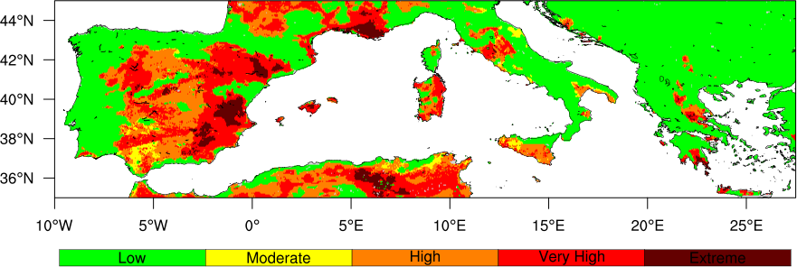
These maps of the fire risk throughout Portugal show (left) the day before the Monchique blaze ignited (2 August), when the probability was rated as “exceptional” for that region, and (right) the day the fire started (3 August)
Satellite Application Facility on Land Surface Analysis
EUMETSAT has a network of eight Satellite Application Facilities which are each dedicated to a particular user community and application area. These dedicated centres of excellence for the processing of satellite data provide users with operational data and software products and form an integral part of the EUMETSAT distributed ground segment.
Each SAF is located within a EUMETSAT Member State’s National Meteorological and Hydrological Service or other entities linked to a user community. They are consortia involving government bodies and research institutes. The EUMETSAT Satellite Application Facility on Land Surface Analysis (LSA SAF) is led by the Instituto Português do Mar e da Atmosfera (IPMA), Portugal and one of the members of the consortium is the Instituto Dom Luiz (IDL) at the University of Lisbon.
The aim of the LSA SAF is to take full advantage of remotely sensed data on land, land-atmosphere interactions and biosphere applications. A strong emphasis is put on developing and implementing algorithms that will allow an operational use of data from EUMETSAT satellites. The LSA SAF generates, archives and disseminates, on an operational basis, a set of parameters involved in the surface radiation budget, evapotranspiration, vegetation cover and fire-related products. More information and access to the data can be found here.
Fire products
Among the fire-related products developed by the EUMETSAT LSA SAF is the product Fire Radiative Power, which provides information about the radiant heat emitted by fires. Scans of Europe produced every 15 minutes by EUMETSAT’s Meteosat Second Generation (MSG) geostationary spacecraft provide this data.
“Back in the 1970s, Canada produced a set of indices based on meteorological parameters – temperature, wind speed, air humidity and precipitation – related to the easiness of a fire building up in intensity or spreading,” Professor DaCamara, who was a member of the LSA SAF, said.
“The LSA SAF calibrated these indices against the database of fire radiative power first measured by MSG.
"What we are producing on a daily basis, using meteorological forecasts from the European Centre for Medium-Range Weather Forecasts (ECMWF), are classes of meteorological fire danger based on a statistical model that gives the probability of having a fire that overcomes a given threshold.
Professor DaCamara said his team found that probability distribution of fire radiative energy follows a predictable pattern.
“What we are producing is a statistical model of probability that once a fire attains a certain level of energy, that it will then attain another level of energy that makes it difficult, or impossible, to contain,” he said.
The model has shown promising results during this fire season. Professor DaCamara is confident that the fire season in Portugal this year will not be as severe as last year and said the Monchique blaze was expectable.

The genesis of the tragic events of the 2017 fire season in Portugal are illustrated in this animation, which covers the period from 13 July to 29 August 2017. The level of risk and the outbreak of fires is clearly shown.
Preconditions for a fire
How can a serious wildfire be expected if, as has happened in a number of cases around the world, it starts as a result of human activities?
Professor DaCamara outlined the three ingredients needed for a major fire:
“The first is meteorological conditions. This can be predicted and can be used to then predict the fire radiative power released by the fires,” he said.
“Secondly, you need vegetation that is stressed by lack of water and heights of temperature. You can have an idea of the status of vegetation at the beginning of the fire season.
“The third is ignition. In Mediterranean countries, especially Portugal, 97 percent of ignitions are man-made, they are not natural, like in Canada. Of those, a huge proportion, 80 percent, are a result of malpractice.”
Those man-made fires include arson but cover other sources of ignition. For example, fire is used in agricultural practices, exactly when the conditions for large fires are prevalent.
The determination that the sources of ignition exist, whether man-made or natural, negligence or arson, are taken into account in the models of probability of having large fires.
Cease Fire
Professor DaCamara’s group has developed a website, called CeaseFire, with daily maps showing the fire risk throughout Portugal. The website uses LSA SAF products, derived from EUMETSAT’s satellite observations, and is sponsored by the Portuguese pulp and paper company, Navigator.
“We have focused on Portugal as we are based here and because of the severity of wildfires we have,” Professor DaCamara said. “We have calibrated this model specifically for Portugal.
“We also received a tender from the World Bank and now produce daily forecasts of the fire danger in the Zambezia Province of Mozambique.”
Professor DaCamara said daily forecasts for the Zambezia region have been produced since June and the results so far are promising.


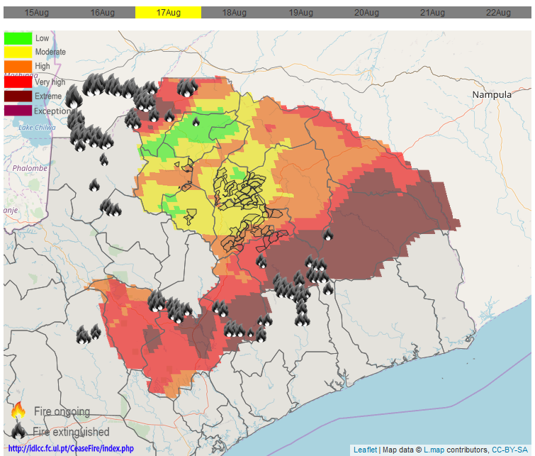

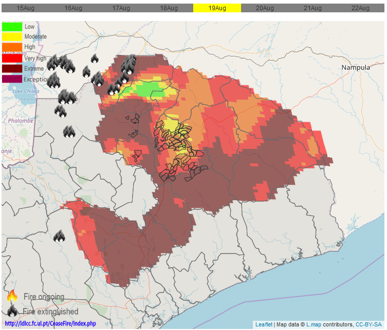
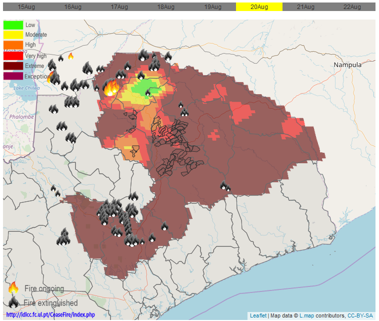
Professor DaCamara’s team now produces daily forecasts of the fire danger in the Zambezia region of Mozambique in a project funded by the World Bank.
Future uses
Other countries, among them Greece and Armenia, have expressed interest in the model and there is scope to extend the forecasts to other regions. However, the particular characteristics of those countries or regions would need to be factored into the modelling.


The fire risk in parts of Greece is clear from the image on top, of the day a deadly wildfire began (23 July). The fire risk visibly decreased over the next two days.
“The product would have to be adapted to the different type of climate and different type of landscape in non-Mediterranean countries,” Professor da Camara said.
“The product will work in other places and can help local authorities in better management and planning, for example, for the distribution of fire-fighting equipment and resources during the fire season.
I also think at European level, it would be useful to help the EU with placing the EU fire-fighting resources where they are needed. I believe there is lots of room for this type of product.
