In the line of fire
Isabel Trigo explains how EUMETSAT satellite data is an increasingly vital tool in managing wildfires in Portugal and across Europe
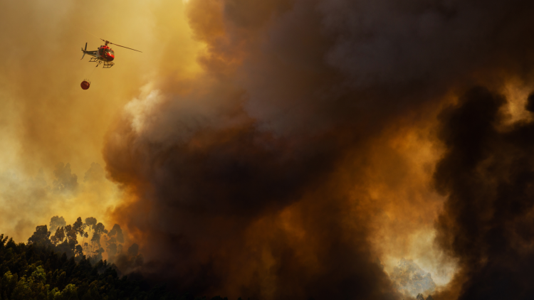
How EUMETSAT’s Satellite Application Facility for Land Surface Analysis provides critical data that supports wildfire management and emergency response teams across Europe.
Now Portugal was once again on high alert.
“With searing temperatures, tinder-dry landscapes, and strong winds, it can only take a spark to ignite an uncontrollable wildfire,” says Dr Isabel Trigo, Head of the Earth Observation Unit at the Portuguese Institute for Sea and Atmosphere, based in Lisbon.
“When extreme fire risk warnings are issued, residents in affected areas are required to act very cautiously, with activities such as campfires, barbecues, and the burning of agricultural waste prohibited.
“Fire risk assessments are underpinned by satellite observations of aspects such as temperature, the moisture within vegetation, and heat from active wildfires.
“Unusual patterns in the data – such as strong deviations from the average – can provide indications of high wildfire risk.
“Bringing diverse datasets together with the latest weather forecasts enables the production of fire risk maps that support proactive decision making.
“Data from meteorological satellite missions can therefore play a crucial role in preventing fires, minimising damage, and improving public safety.”

Image: EUMETSAT LSA SAF
The bigger picture
In 2022, Europe’s summer wildfire emissions were the highest in 15 years. And despite improvements in fire management methods, recent years have seen a marked shift in wildfire patterns in Portugal and across many parts of the continent.
“In some habitats, wildfires are an essential part of ecosystem dynamics,” explains Trigo, who is Manager of EUMETSAT’s Satellite Application Facility for Land Surface Analysis (LSA SAF), which provides operational fire risk maps and other relevant information related to wildfires in near-real-time.
“However, over the past two decades there has been an increase in catastrophic and uncontrollable megafires in Europe, particularly where there is substantial fuel for fires to burn such as forests or a build-up of vegetation.
“Wildfire seasons are getting longer on average and increasingly affecting areas less accustomed to fires, including in parts of central and northern Europe.”
Trigo says these patterns are largely due to human-driven impacts such as climate change and changes in land use.

Image: Processed by Pierre Markuse using Copernicus Sentinel data

“The impacts we are seeing can create a vicious cycle – severe drought conditions further reduce evapotranspiration and can exacerbate heat waves,” she says.
“In addition, larger fires can destabilise the atmosphere, with the resulting winds and lightning potentially causing further problems.
“Left unchecked, the situation can rapidly spiral out of control.”
In 2017 Portugal suffered some of the biggest fire-related tragedies in its history, with more than 100 people killed in two separate events at either end of the fire season.
“In June of 2017, a combination of tinder-dry conditions and atmospheric instability led to the biggest firestorm ever recorded in Portugal,” Trigo recalls. “Columns of very hot air pulled flames skywards and many people died trying to flee the flames.
“Four months later, in October, hundreds of fires across northern Portugal and north-western Spain, most ignited through negligent use of fire or arson, rapidly spread when fanned by remnants of hurricane Ophelia.
“This led to dozens of fatalities and the largest burn scar ever recorded in Portugal in a single day.”


Unlike with hurricanes and blizzards, it is not possible to pinpoint exactly when and where major fires will occur.
“One way we can narrow down uncertainties and improve preparedness is by turning to meteorological satellite data,” Trigo says.
“EUMETSAT’s LSA SAF develops and implements products that take land surface and related data provided by EUMETSAT’s Meteosat and Metop satellites, as well as algorithms that turn this data into measurements of key variables such as land surface temperature, vegetation cover, fire emissions, and fire radiative power.
“LSA SAF products utilise many data channels providing observations of the land's surface in the visible and infrared domains.
“These datasets feed applications such as assessments of fire risk forecasts, measurements of fire hotspots in near-real time, and assessments of fire impacts,” Trigo says.
“They also support everything from short-range forecasts to long-term climate studies at regional, continental, and global scales, and are increasingly used to study the environmental and social factors underlying fire outbreaks.
“Our challenge as product developers is to maximise the potential of EUMETSAT’s incredible datasets for diverse users.”

Isabel Trigo says EUMETSAT’s next-generation missions Meteosat Third Generation and the EUMETSAT Polar System-Second Generation will further increase the role satellite data play in monitoring wildfires.
Future focus
Next-generation satellite missions such as EUMETSAT’s Meteosat Third Generation (MTG) and the EUMETSAT Polar System-Second Generation (EPS-SG) will further increase this potential, Trigo explains.
“EUMETSAT’s next-generation missions will increase the spatial and temporal collection of data and provide new channels of information,” she says.
“This will provide both continuity of existing services, and open up opportunities for new products that can support wildfire management.
“One example is data provided by MTG’s Flexible Combined Imager – on board the recently launched first imager satellite – which will help to increase the detectability of fires by providing a better spatial representation of fires on the ground, or more pixels per image.
“This will present the chance to develop products that can allow authorities to identify wildfires earlier and later in their life cycles, and to monitor smaller, weaker fires previously undetectable by satellite sensors.
“MTG data will also enhance near-real-time monitoring of fire hotspots, ultimately providing images every 2.5 minutes over Europe. This will enable experts to track the evolution of fires over time in finer detail.”
While Meteosat satellites in geostationary orbit are invaluable for keeping a constant eye on the same part of the Earth surface, Metop polar-orbiting satellites pass much closer to ground – and Trigo says spacecraft in the EPS-SG programme will provide richer datasets when the system is deployed, whilst also delivering more images per day.
“EPS-SG data will present enormous opportunities to enhance products detailing albedo, fire emissions, burned areas, vegetation stress, and soil moisture – useful for applications such as fire risk maps and burned area assessments.
“For the first time, we will also be able to derive global fire radiative power using data provided by Metop satellites – EPS-SG will therefore allow us to increase the range of products that we derive globally.
“The programme is going to deliver a huge leap in capabilities.”
In terms of applications, Trigo says the biggest challenges lie in combining diverse datasets provided by geostationary and polar-orbiting missions in ways that make them accessible to a wide variety of end users – including forecasters, emergency responders, and climate scientists.
“Observations made using microwave channels, for instance, can provide phenomenal insights into vegetation moisture and roughness, however microwaves are of a very different nature to optical data,” Trigo says.
“We aim to find ways to better integrate these very different channels of information and turn that into understanding.
“On the one hand, we anticipate that researchers will be able to gain deeper insights into fundamental processes on the land and atmosphere, which could improve the outputs of climate and weather models,” she explains.
“On the other hand, it could be possible to combine near-real-time information on wildfires with very short-range weather forecasts – or nowcasts – to better predict the progression of fires in the coming hours.
“This is an area where new and evolving tools such as artificial intelligence could make a difference, as they will enable better integration of diverse datasets with other Earth observation data such as local orography and landcover.
“Emergency responders could gain a better idea of where the frontlines of fires are likely to be and how fires might play out in different scenarios.
“These are the kinds of tools that firefighters say would be invaluable in allocating resources, getting people to safety, bringing fires under control, and minimising the impacts on communities and the environment.”
The near-real-time products of EUMETSAT’s LSA SAF can be accessed via EUMETCast or on the LSA SAF homepage.
Author:
Adam Gristwood