Satellites over Africa save lives
From improved tropical storm forecasts to more accurate wildfire monitoring, new satellite programmes will make a big difference in Africa
Harsen Nyambe Nyambe from the African Union Commission explains how satellite data contribute to saving lives in Africa.
17 June 2024
22 May 2024
Last spring, Cyclone Freddy tore across south-eastern Africa. It hit Malawi the hardest, pummeling the country with six months’ worth of rain in only six days. There, flash floods and mudslides swept away entire villages. In the end, the record-breaking storm took the lives of an estimated 1,500 people across five countries.
Harsen Nyambe Nyambe, Director of Sustainable Environment and Blue Economy at the African Union Commission, led a delegation to assess the impacts of Cyclone Freddy and noted that early warning systems are crucial for minimising the loss of life from natural disasters.
“In Mozambique and Madagascar, which are frequently hit by storms and have thus strengthened their early-warning systems, fewer people lost their lives in Cyclone Freddy than in Malawi, where there's no robust early-warning system,” said Nyambe.
Early warnings are particularly important in many regions of Africa, where the impacts of climate change disproportionately affect some of the most vulnerable communities. For much of the continent, satellite data are crucial inputs for early warning systems, as well as for enabling meteorologists to better predict and monitor the more frequent and intense extreme weather events induced by climate change.
“Satellites are a very reliable source of weather and climate data in Africa because in most African countries, there are very few weather stations on the ground. So, we depend on satellites for information about rainfall, floods, droughts, wildfires, and other extreme events,” said Nyambe.

Satellite data are also crucial for assessing the health of forests and mapping forest resources in Africa. When wildfires ignite, satellite images can be used to detect forest fires, monitor ash and trace gas emissions, and identify burned areas. They also aid in identifying land that has been degraded and water afflicted with harmful algal blooms.
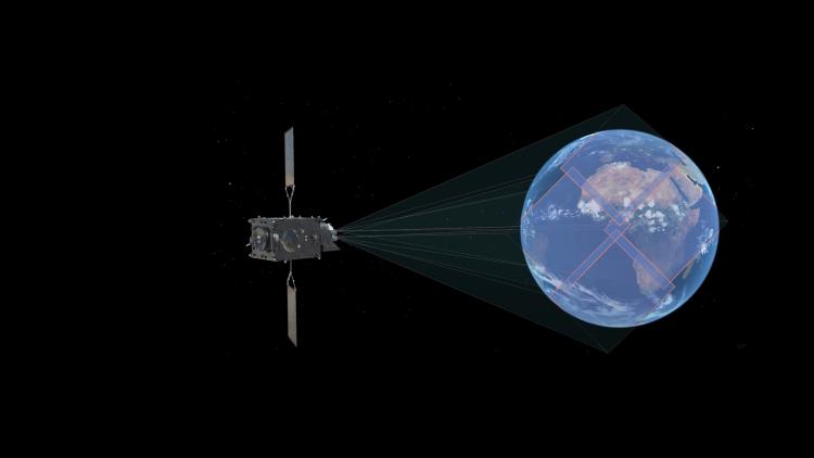
Nyambe is looking forward to two upcoming satellite programmes to further improve weather, climate, and environmental monitoring: Meteosat Third Generation (MTG) with its MTG satellites and the EUMETSAT Polar System-Second Generation (EPS-SG) programme with its Metop-Second Generation (Metop-SG) satellites.
Both programmes will provide improved and novel observations that will be used directly for monitoring and nowcasting the weather, as well as inputs into numerical weather prediction models, making it possible to more accurately predict the weather and better monitor the climate and environment worldwide and in Africa in particular.
Each programme will provide a variety of complementary benefits for Africa. With their continuous view of the continent – as well as of Europe and part of the Indian Ocean – MTG satellites will be particularly beneficial for Africa. More frequent images from the Flexible Combined Imager — every 10 minutes rather than every 15 from the equivalent instrument on current Meteosat Second Generation satellites — as well as new spectral channels mean more accurate predictions and better monitoring of tropical cyclones, thunderstorms, and wildfires.
Observations from the Lightning Imager, a new instrument on MTG, contribute essential data about thunderstorms in regions of Africa where they are particularly beneficial, such as the Congo River Basin, a lightning hotspot, as well as across the tropical and subtropical belt, where powerful thunderstorms are frequent.
Complementary observations from a few key instruments on board Metop-SG satellites will also contribute to protecting people in Africa from weather hazards. Observations from the METimage and microwave sensors will help improve precipitation forecasts and those from the scatterometer will provide information about ocean surface winds, drought conditions, and for flood prediction. These instruments will support the monitoring and prediction of tropical cyclones and associated extreme rainfall events.
At the end of the day, what is most important is making sure the information based on satellite data reaches the people who need it most.
“When I hear that people were not killed by a storm because early warning information arrived there, I feel we have contributed something tangible as the African Union,” said Nyambe.
“That’s the most satisfying thing we can do.”
Author:
Sarah Puschmann