


26 February 2026
19 March 2020
This allows us to take images of the Earth disc at very high frequency, in the order of some minutes
The Meteosat-10 and -11 are in geostationary orbit over Europe and Africa, while Meteosat-9, operates over the Indian Ocean. Meteosat-11 is the prime operational geostationary satellite, positioned at 0 degrees and providing full disc imagery every 15 minutes. Meteosat-10 provides the Rapid Scanning Service, delivering more frequent images every five minutes over parts of Europe, Africa and adjacent seas.
The Metop satellites fly in a lower polar orbit, at an altitude of 817 kilometres, and provide more detailed observations of the global atmosphere, oceans and continents. Metop-A, the first European polar-orbiting meteorological satellite, was launched in October 2006 and delivered operational data from 15 May 2007 to 15 November 2021. Metop-B was launched on 17 September 2012, and has been the primary operational satellite since 24 April 2013. Metop-C was launched on 7 November 2018.
EUMETSAT Ground Segment
The ground segment constitutes the ground-based infrastructure necessary to support the operation of our satellites, including the control of our spacecraft in orbit, and the acquisition, reception, processing and delivery of their data.
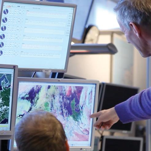
The EUMETSAT Mission Control Centre (MCC) is based at our headquarters in Darmstadt, Germany, and is responsible for the safe operation of all satellites. Comprised of two main control rooms, one for the geostationary missions and the other for the low Earth orbit missions, it provides the necessary monitoring and control of all operational satellites and the associated ground infrastructure. It also ensures the continued communication with – and data acquisition from – satellites through a network of primary and backup ground stations distributed across Europe. Teams of satellite and ground segment controllers work around the clock, supported by teams of on-call operators and maintenance engineers.
Physical parameters – the so-called Level 1 products – are extracted from satellite observations at our headquarters, together with some geophysical parameters – the so-called Level 2 products. The Products page has a full list of products, which primarily support the application needs for Nowcasting and Numerical Weather Prediction (NWP).
In addition, to exploit the full potential of our satellite data in a broad range of meteorological and environmental applications, our ground segment also includes a network of eight Satellite Application Facilities (SAFs) that each specialise in the delivery of products in one application area.
Each SAF is a consortium of institutes from Member States, led by a National Meteorological Service. Today, this network allows the best use of distributed resources for the development and delivery of innovative products, making the most of specialised scientific expertise, closer interactions with application experts, and cross-network co-operation.
The set of data and products generated across our ground segment are then delivered to users in real time and off line. Explore our User Portal to learn more about data access.