Behind the data: tracking Iceberg A23a with Copernicus Sentinel-3 data
How Earth observation satellites monitor the evolution of Antarctic Iceberg A23a

Key points
The United Nations has designated the period 2021-2030 as the Decade of Ocean Science for Sustainable Development and issued ten challenges with the goal of achieving a clean, safe, and accessible ocean by 2030. To support this goal, EUMETSAT is developing case studies that address each of the United Nations’ challenges. This article is the ninth in a series in which one case study author gives us the story behind the data, illuminating how satellite data from EUMETSAT and the European Union’s Copernicus programme contribute to a better future for us and our ocean.
Key points:
- After being grounded for 34 years, Iceberg A23a began to drift in 2020.
- Its movement was captured by observations from the Ocean and Land Colour Instrument (OLCI) on board the Copernicus Sentinel-3 satellite.
- Monitoring icebergs is important for marine safety, particularly in the Arctic; monitoring contiguous sea ice is important for climate adaptation.
From its calving from an Antarctic ice shelf to its drift across the Southern Ocean, Iceberg A23a’s journey is revealed through Copernicus Sentinel-3 satellite data. The Copernicus Marine Training Service Coordinator at EUMETSAT, Dr Ben Loveday explains why continuous Earth observation is essential for understanding our changing planet.
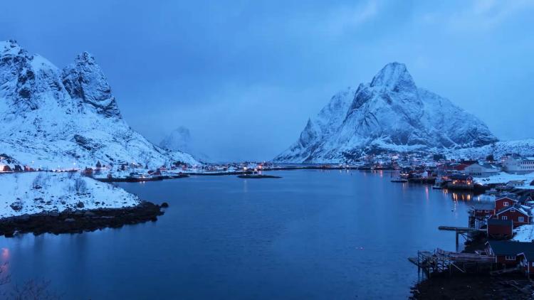
Journey of an iceberg
“By the beginning of this video, we are picking the iceberg up when it was at the very edge of the sea ice. In 2023, it was starting to reach a point when it was not packed in with any more sea ice that would block it, and was breaking away from the pack ice. From that point onwards, it was free to be moved by the water around it and to drift into the Southern Ocean.
Credit: Dr Ben Loveday
“In general, we can say that the currents in the Southern Ocean go from west to east, following the strong circumpolar current that goes all the way around Antarctica. In this video, can see that the iceberg went east, almost directly toward the island of South Georgia.
“There are a number of different remote sensing techniques that can be used to monitor icebergs. In most cases, operational monitoring of icebergs is performed using synthetic aperture radar as this is not blocked by cloud, but in many cases you can also monitor them with optical instruments. We have done that here with the Copernicus Sentinel-3 Ocean and Land Colour Instrument (OLCI), which is a medium-resolution satellite that is more than up to the task of spotting larger icebergs when the available light field and cloud cover permit.
“For instance, during the southern hemisphere winter, we do not have enough light for optical sensors to work, so we lose the ability to track icebergs around Antarctica through these instruments. This is also true for the Arctic during the northern hemisphere winter. While we typically rely on radar to give year-round coverage of these regions, it is also possible to use infrared sensors during these periods, provided the icebergs are large enough. These sensors, such as Copernicus Sentinel-3 Sea and Land Surface Temperature Radiometer (SLSTR), do not rely on visible light, but instead record the emitted brightness and can give us additional information on sea ice coverage and sea ice surface temperature, which is very useful for maritime situational awareness and climate monitoring.
“By around 28 April 2024, there was no longer enough light to see the iceberg with OLCI. Around 7 September 2024 the light returned and we could see the iceberg continuing to head towards South Georgia, driven by the wind and current, in the Southern Ocean. In March 2025, it reached South Georgia and became grounded on the shallows of the continental shelf, where it continued to fragment due to wave action and friction against the shelf.
“In late April 2025, we lost the light again, so this is where the video ends. But at some point in the next few months, the iceberg broke away from South Georgia, travelled south of the island and then headed towards the north into where the Southern Ocean meets the South Atlantic Ocean. There, the water is a lot warmer. Since then, it has been decaying gradually, mostly by melting, and will likely be entirely gone by early 2026.
“In the northern hemisphere, monitoring icebergs for maritime safety is an essential activity. This has become especially important as there are more free-floating icebergs and icebergs are starting to have lower coverage, together with the shipping lanes being busier now than they have been historically.”
Pattern of decreasing sea ice extent
“This graph gives an idea of the sea ice extent in the southern hemisphere around the Antarctic Peninsula, taken from the data from the EUMETSAT Ocean and Sea Ice Satellite Application Facility.”
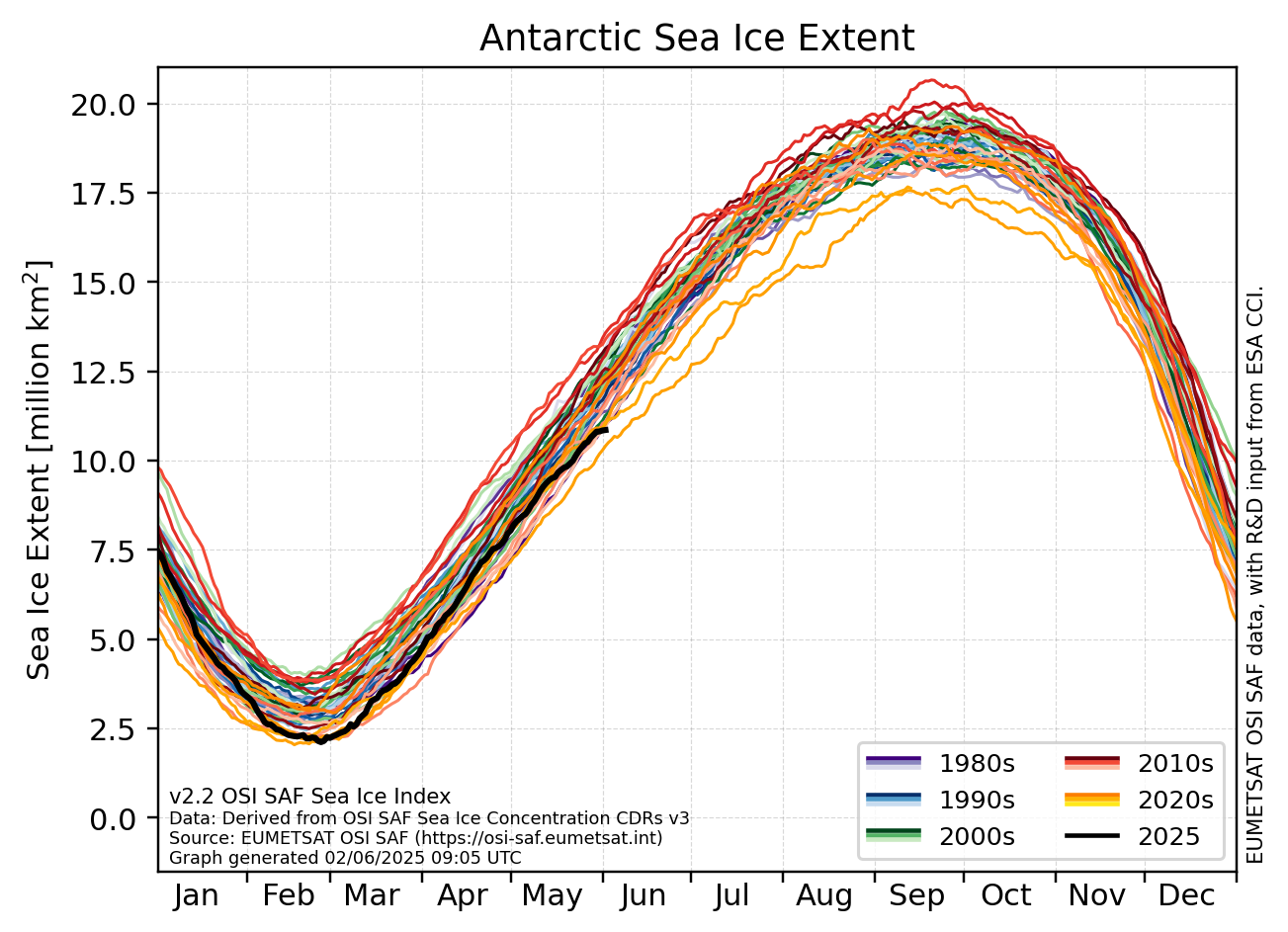
Credit: Dr Ben Loveday, OSI SAF
“This graph shows the sea ice extent around the Antarctic continent, defined as the total area of ocean where the sea ice concentration exceeds a threshold of 15%. As such, it does not include free floating icebergs. However, it does provide some wider context regarding Antarctic ice. Towards the start of 2025, the sea ice extent was very low, which you can see by how far down the black line dips in late February and early March.
“It is worth pointing out that although 2026 was not pictured on this graph, it has been a fairly medium year when it comes to sea ice extent. This year – at least, so far – has not continued the pattern of decreasing sea ice extent in the Antarctic that we had seen over the five or six years leading up to 2025.
“When we talk about sea ice coverage, we are generally talking about the sea ice that is still packed in and stuck together. This ice plays an important role in the climate system in general. In the near future, we hope to be able to better monitor sea ice and the oceans around it using new missions that will be added to the Copernicus fleet. The Copernicus Polar Ice and Snow Topography Altimeter (CRISTAL), which is a specifically cryosphere- and ocean-focused mission, will increase our ability to study sea and land ice as well as improve our ability to monitor the dynamics of the polar oceans, improving our ability to track icebergs when they are ejected into the open ocean.
“In addition, the Copernicus Imaging Microwave Radiometer (CIMR) will allow us to monitor the northern polar regions with unprecedented spatial resolution without being affected by clouds. This will greatly improve our ability to track evolutions of Arctic sea ice.
“Monitoring sea ice is essential for understanding climate change, protecting ecosystems, and predicting global weather patterns. Missions like CRISTAL and CIMR will provide more precise, year-round data on ice thickness and extent, giving us a clearer picture of how the polar regions are evolving and allowing us to better adapt.”
Interested in diving deeper?
Check out the case study and the interactive Destination Earth Digital Earth Architecture story.
Author:
Sarah Puschmann