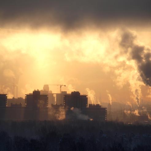
The emission missions
How EUMETSAT’s meteorological satellite programmes are helping specialists better understand climate change and its effects

Rosemary Munro, Polar System Programme Scientist, reflects on how EUMETSAT’s meteorological satellite missions contribute to a greater understanding of emissions contributing to climate change and poor air quality – and their effects.
17 January 2024
30 November 2023
Ammonia from fertilisers and livestock plays a central role in the cycle of air pollution, which contributes to the deaths of millions of people around the world every year.
Yet when researchers from the Université libre de Bruxelles, Belgium, studied a decade’s worth of global ammonia emissions data from EUMETSAT’s Metop polar-orbiting satellites, they found that two-thirds of hotspots were previously unknown.
“While ammonia only stays in the air for a few hours, when it combines with other polluting gases it can generate dangerous particulate matter that can persist for several days and travel long distances,” says Dr Rosemary Munro, EUMETSAT’s Polar System Programme Scientist.

Credit: Martin Van Damme and Lieven Clarisse / ULB
To carry out the 2018 study, specialists turned to data provided by Metop’s Infrared Atmospheric Sounding Interferometer (IASI).
“Metop is a multi-decadal programme that consistently delivers data on all sorts of parameters from the Earth’s land, ocean, ice, and skies,” says Munro. “This includes temperatures, wind speeds, ice cover, sea levels, humidity, flooding, vegetation cover, wildfires, and a wide range of different types of gases.
“As IASI passes overhead in low-Earth orbit, it takes measurements of ‘columns’ extending from the stratosphere to the Earth’s surface, with a circumference roughly the size of Paris.
“Using this data, specialists estimated the vertical density of ammonia around the world. The study demonstrated how time-series satellite data can be used to pinpoint the origins of emissions, understand how levels fluctuate, and help attribute pollution to specific sources or environmental events.”

Credit: CNES/REGY Michel
Improving emissions monitoring
Increasingly, the focus of meteorological satellite programmes is being expanded to zoom in on not just the quantities and concentrations of emissions in the atmosphere, but – like with the ammonia study – also their sources.
One example is the forthcoming Copernicus CO2 Monitoring Mission (CO2M), a low-Earth orbit programme that will track carbon dioxide emissions from anthropogenic sources. EUMETSAT will operate the mission’s spacecraft, due to launch in the mid-2020s, and process and disseminate the data.
“CO2M satellites will host near-infrared and shortwave-infrared spectrometers that will support countries in compiling inventories of greenhouse gas emissions, which must be submitted every five years under the Paris Agreement,” says Munro.
“At present, nationally determined contributions are calculated in a ‘bottom up’ way. This involves combining data on types of activity, such as oil and gas consumption, with calculations of emissions typically produced by those activities.
“Less is known about the exact sources of emissions.”

Credit: OHB
Sensors on CO2M instruments will take detailed measurements of carbon emissions, and will also enable specialists to differentiate between human-produced sources of carbon dioxide and those emitted by natural processes.
“CO2M offers an independent perspective that will detail major emission sources and help verify and improve the accuracy of national estimations,” Munro says.
“The data will also contribute to a bigger picture. For example, the mission will also deliver data on other greenhouse gases such as methane, the pollutant nitrogen dioxide and aerosols. This is important because often the same processes that cause carbon emissions also release other species of greenhouse gases and/or air pollution.
“For example, atmospheric ammonia is not just a noxious gas in itself – large quantities of carbon dioxide are emitted when ammonia is produced and the substance can also be broken down by bacteria in the soil, generating vast quantities of nitrous oxide as a by-product.”
Nitrous oxide is a long-lived and potent greenhouse gas that the Intergovernmental Panel on Climate Change says is responsible for roughly 6% of global greenhouse gas emissions. In recent years it has continued to increase at an alarming rate and Munro says having this wider picture is critical for guiding effective policies to combat climate change.
“In the past, policies that have aimed to reduce carbon emissions have sometimes led to increases in other pollutants – an example is legislation to reduce carbon dioxide from combustion engines, which led to more emissions of nitrogen oxides,” she points out.
“Meteorological satellite data can help to quickly identify if measures to reduce emissions are working, or if they might inadvertently have side effects that impact human health and the environment.”

Next-generation coverage
As EUMETSAT’s Polar System Programme Scientist, Munro is currently focused on preparing for the EUMETSAT Polar System – Second Generation (EPS-SG) and the Metop Second Generation (Metop-SG) satellites.
Due to launch in the mid-2020s, Metop-SG spacecraft will host a diverse range of instruments that will contribute valuable data towards tracking and tracing emissions from a low-Earth polar orbit.
“Metop-SG instruments will enable more detailed observations of a large range of gases relevant to climate and air quality applications, such as carbon monoxide, methane, ammonia, and stratospheric ozone,” she says.
“They will also allow specialists to look at phenomena such as ice clouds, ocean surface winds, and aerosols in new ways – including types of aerosols produced during combustion processes and volcanic eruptions.
“One major benefit of these observations is that they will help to improve climate models. For example, there is still a lot that we don’t know about the effects that aerosols have on incoming and outgoing radiation at the top of the atmosphere, which determines their heating or cooling impacts on the Earth.
“Another benefit will be the ability to characterise the absorption structures of gases in finer detail, presenting the possibility to observe a wider range of pollutants, for example from wildfires, which will benefit air quality predictions.”

Credit: EUMETSAT
Next-generation geostationary satellites will also contribute substantially to new emissions monitoring applications, providing regular observations always focused on the same part of the Earth.
“The combination of new polar-orbiting and geostationary programmes will provide multi-angle views that can help assess emissions reduction strategies and track the long-range transport of emissions,” says Munro.
“Meteosat Third Generation sounder satellites, for instance, will host the Copernicus Sentinel-4 mission, which includes an ultraviolet-visible-near-infrared light imaging spectrometer instrument.
“This will be the first instrument in geostationary orbit over Europe to provide air quality measurements of aerosols and trace gases such as ozone, nitrogen oxides, sulphur dioxide, and formaldehyde.
“One of the aspects that is particularly important when monitoring emissions is their concentrations, which can vary greatly depending on weather conditions or the time of day when there are peaks in traffic or industrial activity.
“Having this information and the resulting improvements to spatial and temporal resolution of data will help specialists to better understand the relationship between pollutant source and receptor regions and also better understand the complex and interrelated impacts of climate change.”

Credit: EUMETSAT
Understanding the climate system
Here, next-generation satellite missions play a crucial role not only in adding new capabilities but in improving the quality and availability of existing datasets.
“This is done, for instance, through initiatives to rescue and restore data from past missions and efforts to increase access to EUMETSAT’s climate datasets and products in regions such as Africa,” Munro explains.
“From these datasets, international teams, including those in EUMETSAT’s Satellite Application Facilities build products known as climate data records, which are geared at meeting the diverse needs of users in policy and research.”
EUMETSAT datasets make substantial contributions to international climate reports compiled by the Intergovernmental Panel on Climate Change, the Copernicus Climate Change Service, and the World Meteorological Organization.
They also underpin atmospheric reanalyses of the global climate carried out by the European Centre for Medium-range Weather Forecasts, helping to detail how aspects such as sea ice extent, cloud cover, and sunshine duration are changing over time.
“We understand that anthropogenic greenhouse gas emissions are the primary cause of climate change,” Munro adds. “We also see the impacts of this change: temperature records broken, more storms and heatwaves, rising sea levels, and melting sea ice and glaciers.
“However, the processes underlying climate change impacts are immensely complex: it’s important to not only measure emissions, but to recognise what we still don’t know about what is happening to the planet and the broad impacts of climate change.
“This is something that makes EUMETSAT’s satellite programmes and those of partner organisations extremely valuable. Knowledge is power, and by bringing countries, people, and expertise together, meteorological satellite data can help shine light on climate change and its effects and gives countries the opportunity to develop informed policies to mitigate impacts.”
Author:
Adam Gristwood